


Why visit Chammanād
Townapedia lists 1 museum or landmark, 3 parks and trails, 18 places to eat, 5 places to stay and 1 attraction in and around town.
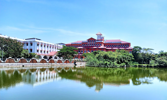
Highlights include Kannur University and Chandragiri fort.
Weather in Chammanād
Forecast from MET Norway (CC BY 4.0). Full forecast
Things to do1
Kannur University
School · 3.3 km
State public university in Kannur, Kerala, India
Museums and landmarks1
Parks, trails and playgrounds3

POYKARA ABDURAHMAN HAJI PARK
Park · 2.4 km
RAILWAY STATION ROAD THAYLANGADI KASARAGOD Railway Station Road, Kasaragod

Restaurants and cafes18

Golden Bakery
Restaurant · Burger, Coffee Shop, Chicken, American, Sandwich, Indian, Seafood, Kebab, Ice Cream, Pizza, Barbecue, Juice, Chocolate · 1.0 km
Kasaragod - Kanhangad state highway, melparamba
Mo-Su 09:00-23:00
AFC
Restaurant · Burger, Fries, Fried Chicken, Fried Food · 1.5 km
Mo-Su 03:00-23:00



6 more on the map.
Where to stay5
GIRLS HOSTEL
Motel and hotel · 1.7 km
Malik deenar nagar thalangara kasargod pin 671122 Railway Station Road, Kasargod
Churches and places of worship20
Shopping10
bismillah
Grocery · 1.4 km
kizhur road ,melparamba centre melparamb - kizhur road, Melparamba
Schools, colleges and libraries22
UBAID SAMSKARIKA KENDRAM
Library · 2.3 km
RAILWAY STATION ROAD THAYLANGADI KASARAGOD Theruvath, Kasaragod
Healthcare10
CITY PHARMACY
Clinic and pharmacy · 1.6 km
opposite muhiyudeen juma masjid Kasaragod - Kanhangad state highway, Melparamba
Map of Chammanād
90 places. The map loads OpenStreetMap tiles when you open it.
Getting there and nearby towns
Mangalore International Airport (IXE) is the nearest airport with scheduled flights listed in OpenStreetMap, 54 km away.
- Kāsaragod 3 km northwest, about 3 min by car
- Chengala 5 km northeast, about 5 min by car
- Uduma 5 km south, about 5 min by car
- Bāre 5 km southeast, about 5 min by car
- Kūdlu 6 km northwest, about 6 min by car
- Madhūru 7 km north, about 7 min by car
- Shiravāgilu 8 km north, about 8 min by car
- Kanhangad 22 km southeast, about 22 min by car
- Mangaluru 51 km north, about 51 min by car
- Irikkūr 81 km southeast, about 1 h 15 min by car
Drive times are estimates from straight-line distance, not routes.
Local news
Headlines from INDB.
Reviews, tips and questions
Loading what members have shared...
Sources and licences
- GeoNames (CC BY 4.0): population, coordinates, regions and time zone
- OpenStreetMap contributors (ODbL 1.0): places, airports, map data
- Wikidata (CC0 1.0): elevation, founding date, time zone, website, landmarks and historic places
- Wikimedia Commons (see each image): photos
Photo credits
- Kannur Univerisity Thavakkara Campus, Rahul B Ashok, CC0
- Aliya Arabic College, Hafeezkv, CC BY-SA 4.0
- Chandragiri Fort, Kerala, Hafeezkv, CC BY-SA 4.0
- Chandrigiri Fort -Kasaragod -Kerala -file 1001, Maqsood Poovadka, CC BY-SA 4.0
- Wiki paravanadukkam, Vijayanrajapuram, CC BY-SA 4.0
- Uri earthen pot uri, Vijayanrajapuram, CC BY-SA 4.0
- Ibrahim Khaleel Road, Thalangara, Prof tpms, CC BY-SA 4.0
- Thalangara Wharf2, Prof tpms, CC BY-SA 4.0
- Police Station Road, Thalangara, Prof tpms, CC BY-SA 4.0
- Thalangara, Kasaragod (7), Prof tpms, CC BY-SA 4.0
- Thalangara, Kasaragod (6), Prof tpms, CC BY-SA 4.0
- Chandrigiri Fort -Kasaragod -Kerala -file 1002, Maqsood Poovadka, CC BY-SA 4.0
- School in Thalangara (1), Prof tpms, CC0
- Thalangara, Kasaragod (8), Prof tpms, CC BY-SA 4.0
- Chandragiri river, Manukrishnan80, CC BY-SA 3.0
- Kannur to Udupi views from train - vrvbsatara102k23pxl (156), Vinayaraj, CC BY-SA 4.0
- Thalangara, Kasaragod (1), Prof tpms, CC BY-SA 4.0
- Saadiya high school, Muzammilmcm, CC BY-SA 4.0
- Thalangara, Kasaragod (2), Prof tpms, CC BY-SA 4.0
- Needle Fish at the Thalangara Wharf, Prof tpms, CC0
- Mosque in Thalangara (3), Prof tpms, CC0
- Kuruthola decoration, Vijayanrajapuram, CC BY-SA 4.0
- School in Thalangara (2), Prof tpms, CC0
- Thalangara Wharf1, Prof tpms, CC BY-SA 4.0
- Thalangara, Kasaragod (3), Prof tpms, CC BY-SA 4.0
- Thalangara, Kasaragod (4), Prof tpms, CC BY-SA 4.0
- Juma Masjid Melepparamba, Kasaragod, Vaikoovery, CC BY 3.0
- Kalvilakku kizhur sastha temple, Vijayanrajapuram, CC BY-SA 4.0
- Malik Deenar Masjidh (4471670795), Shareef Taliparamba, CC BY-SA 2.0
- Malik Deenar Township Thalangara (1), Prof tpms, CC0
- Malik Deenar Township Thalangara (3), Prof tpms, CC0
- Restaurant in Thalangara (3), Prof tpms, CC0
- Restaurant in Thalangara (1), Prof tpms, CC0
- Malik Deenar Gate, Vaikoovery, CC BY 3.0
- Restaurant in Thalangara (2), Prof tpms, CC0
- Arch red stone vijayan rajapuram, Vijayanrajapuram, CC BY-SA 4.0
- Arch red stone kizhur, Vijayanrajapuram, CC BY-SA 4.0
- Arayal - kizhur sastha Temple, Vijayanrajapuram, CC BY-SA 4.0
- Malik Deenar Township Thalangara (2), Prof tpms, CC0
- Mosque in Thalangara (2), Prof tpms, CC0


Page built November 3, 2026. Spotted a mistake? Tell us or suggest a place.