




Why visit Perole
Townapedia lists 9 parks and trails, 6 places to eat, 1 place to stay and 1 attraction in and around town.
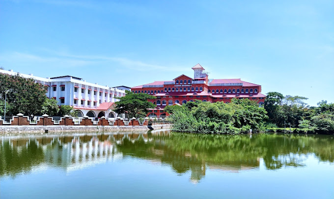
Highlights include Kannur University.
Weather in Perole
Forecast from MET Norway (CC BY 4.0). Full forecast
Things to do1
Kannur University
School · 3.5 km
State public university in Kannur, Kerala, India
Parks, trails and playgrounds9

C H Muhammed Koya Smaraka Government Vocational Higher Secondary School Kottapuram
Playground · 2.3 km


Restaurants and cafes6

Safe Cafe Restaurant
Restaurant · Regional · 1.3 km
Kasargod-Kannur-Calicut Highway, NILESHWAR



Where to stay1

Grand View Residency
Motel and hotel · 1.1 km
Main bazar Nileshwar , Near Krishibhavan, Nileshwar , Kasargod dst.
Churches and places of worship21
Kottam Sri Vettaikkorumakan Temple
Place of worship · 1.4 km
Padinhattam Kozhuval
Shopping1
Gas and EV charging2
Schools, colleges and libraries26
E M S Smaraka Vayanasala & Grandalayam Chathamath
Library · 2.3 km
Nileshwaram Muncipality
Healthcare7
Thejaswini Co-Operative Hospital & Medical Research Center Ltd.
Hospital · 1.9 km
Map of Perole
74 places. The map loads OpenStreetMap tiles when you open it.
Getting there and nearby towns
Kannur International Airport (CNN) is the nearest airport with scheduled flights listed in OpenStreetMap, 58 km away.
- Nīlēshwar 1 km northwest, about 1 min by car
- Kanhangad 7 km northwest, about 7 min by car
- Pilikōdu 8 km south, about 8 min by car
- Ajānūr 10 km northwest, about 10 min by car
- Māriyāt 10 km south, about 10 min by car
- Karuvellūr 11 km southeast, about 11 min by car
- Trikarpūr North 13 km south, about 13 min by car
- Irikkūr 54 km southeast, about 54 min by car
- Panoor 73 km southeast, about 1 h 15 min by car
- Mangaluru 80 km northwest, about 1 h 15 min by car
Drive times are estimates from straight-line distance, not routes.
Local news
Headlines from INDB.
Reviews, tips and questions
Loading what members have shared...
Sources and licences
- GeoNames (CC BY 4.0): population, coordinates, regions and time zone
- OpenStreetMap contributors (ODbL 1.0): places, airports, map data
- Wikidata (CC0 1.0): elevation, founding date, time zone, website, landmarks and historic places
- Wikimedia Commons (see each image): photos
Photo credits
- Perole village office, Ajeeshkumar4u, CC BY-SA 3.0
- Rajahs High School Nileshwar, Ajeeshkumar4u, CC BY-SA 4.0
- Kannur Univerisity Thavakkara Campus, Rahul B Ashok, CC0
- Kannur to Udupi views from train - vrvbsatara102k23pxl (92), Vinayaraj, CC BY-SA 4.0
- Kannur to Udupi views from train - vrvbsatara102k23pxl (91), Vinayaraj, CC BY-SA 4.0
- Kannur to Udupi views from train - vrvbsatara102k23pxl (97), Vinayaraj, CC BY-SA 4.0
- Kannur to Udupi views from train - vrvbsatara102k23pxl (96), Vinayaraj, CC BY-SA 4.0
- Kannur to Udupi views from train - vrvbsatara102k23pxl (93), Vinayaraj, CC BY-SA 4.0
- Kannur to Udupi views from train - vrvbsatara102k23pxl (95), Vinayaraj, CC BY-SA 4.0
- Kannur to Udupi views from train - vrvbsatara102k23pxl (94), Vinayaraj, CC BY-SA 4.0
- Nileshwar palace building -May 2023, Ajeeshkumar4u, CC BY-SA 4.0
- Kannur to Udupi views from train - vrvbsatara102k23pxl (111), Vinayaraj, CC BY-SA 4.0
- Kannur to Udupi views from train - vrvbsatara102k23pxl (113), Vinayaraj, CC BY-SA 4.0
- Kannur to Udupi views from train - vrvbsatara102k23pxl (114), Vinayaraj, CC BY-SA 4.0
- Kannur to Udupi views from train - vrvbsatara102k23pxl (117), Vinayaraj, CC BY-SA 4.0
- Kannur to Udupi views from train - vrvbsatara102k23pxl (109), Vinayaraj, CC BY-SA 4.0
- Kannur to Udupi views from train - vrvbsatara102k23pxl (108), Vinayaraj, CC BY-SA 4.0
- Kannur to Udupi views from train - vrvbsatara102k23pxl (115), Vinayaraj, CC BY-SA 4.0
- Kannur to Udupi views from train - vrvbsatara102k23pxl (105), Vinayaraj, CC BY-SA 4.0
- Kannur to Udupi views from train - vrvbsatara102k23pxl (106), Vinayaraj, CC BY-SA 4.0
- Kannur to Udupi views from train - vrvbsatara102k23pxl (112), Vinayaraj, CC BY-SA 4.0
- Kannur to Udupi views from train - vrvbsatara102k23pxl (110), Vinayaraj, CC BY-SA 4.0
- Kannur to Udupi views from train - vrvbsatara102k23pxl (116), Vinayaraj, CC BY-SA 4.0
- Kannur to Udupi views from train - vrvbsatara102k23pxl (107), Vinayaraj, CC BY-SA 4.0
- Nileshwaram railway station, Sujithshivam511, CC BY-SA 4.0
- Nileshwaram, railway station, Sujithshivam511, CC BY-SA 4.0
- Kannur to Udupi views from train - vrvbsatara102k23pxl (104), Vinayaraj, CC BY-SA 4.0
- Kannur to Udupi views from train - vrvbsatara102k23pxl (101), Vinayaraj, CC BY-SA 4.0
- Kannur to Udupi views from train - vrvbsatara102k23pxl (98), Vinayaraj, CC BY-SA 4.0
- Kannur to Udupi views from train - vrvbsatara102k23pxl (100), Vinayaraj, CC BY-SA 4.0
- Kannur to Udupi views from train - vrvbsatara102k23pxl (103), Vinayaraj, CC BY-SA 4.0
- Kannur to Udupi views from train - vrvbsatara102k23pxl (99), Vinayaraj, CC BY-SA 4.0
- Kannur to Udupi views from train - vrvbsatara102k23pxl (102), Vinayaraj, CC BY-SA 4.0
- Corneal opacity right eye 2, Ajeeshkumar4u, CC BY-SA 4.0
- Corneal opacity right eye, Ajeeshkumar4u, CC BY-SA 4.0
- Jackson cross cylinder 2, Ajeeshkumar4u, CC BY-SA 4.0
- Jackson cross cylinder, Ajeeshkumar4u, CC BY-SA 4.0
- Autorefractometry, Ajeeshkumar4u, CC BY-SA 4.0
- Fundus examination, Ajeeshkumar4u, CC BY-SA 4.0
- Fundus examination 2, Ajeeshkumar4u, CC BY-SA 4.0


Page built November 3, 2026. Spotted a mistake? Tell us or suggest a place.