


Why visit Taliparamba
Townapedia lists 1 museum or landmark, 14 parks and trails, 77 places to eat, 22 places to stay and 3 attractions in and around town.
Highlights include Kannur University and Parassinikkadavu Snake Park.
Weather in Taliparamba
Forecast from MET Norway (CC BY 4.0). Full forecast
About Taliparamba
Taliparamba (also known as Perinchelloor and Lakshmipuram) is a Municipality and Taluk of Kannur district in Kerala state, India. The municipal town spreads over an area of 18.96 square kilometres (7.32 sq mi) and is inhabited by 44,247 number of people.
From the Wikipedia article Taliparamba (this version), under CC BY-SA 4.0.
Travel tips from other travellers: Taliparamba on Wikivoyage (CC BY-SA 4.0).
Things to do3
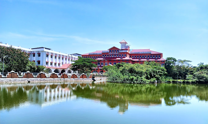
Kannur University
School · 6.6 km
State public university in Kannur, Kerala, India

Museums and landmarks1

Parks, trails and playgrounds14


Parassinikkadavu Snake Park
Park · 6.6 km
Snake Park in Kerala, south India



2 more on the map.
Restaurants and cafes77

Krishna Hotel
Restaurant · Malabar
Taliparamba Pattuvam Cherukunnunu Koovappuram Road, Taliparamba
Mo,Tu,Th,Fr 09:00-12:00,13:30-18:30; We 09:00-12:00,13:30-20:00;...


al madeena
Restaurant · Barbecue, Beef Bowl, Chicken, Chinese, Coffee Shop, Curry, Fish, Fish And Chips, Noodle · 5.3 km
Mo,Tu,Th,Fr 09:00-12:00,13:30-18:30; We 09:00-12:00,13:30-20:00;...
amrutha
Restaurant · Indian, Chinese, Chicken · 1.6 km
Mo,Tu,Th,Fr 09:00-12:00,13:30-18:30; We 09:00-12:00,13:30-20:00;...
arabian
Restaurant · Indian, Chinese · 0.9 km
Mo,Tu,Th,Fr 09:00-12:00,13:30-18:30; We 09:00-12:00,13:30-20:00;...
highway inn
Restaurant
Mo,Tu,Th,Fr 09:00-12:00,13:30-18:30; We 09:00-12:00,13:30-20:00;...
hotel vrindavan
Restaurant · Fish, Chicken, Indian · 2.3 km
Mo-Su 09:00-12:00,13:30-18:30; We 09:00-12:00,13:30-20:00; Sa...
safa food
Restaurant · Arab · 2.4 km
Mo-Su 09:00-12:00,13:30-18:30; We 09:00-12:00,13:30-20:00; Sa...
Arjun special food
Bakery · 1.1 km
Mo,Tu,Th,Fr 09:00-12:00,13:30-18:30; We 09:00-12:00,13:30-20:00;...
atos bakes and cool
Bakery · 1.6 km
Mo,Tu,Th,Fr 09:00-12:00,13:30-18:30; We 09:00-12:00,13:30-20:00;...
65 more on the map.
History
Taliparamba was one of the traditional establishments in ancient Kerala. It is located in erstwhile Kolathunadu, which was ruled over by the Mushika/Kolathiri/Chirakkal Royal Family. It was also once a part of the Mannanar dynasty. As per tradition, Taliparamba originated as the Perinchalloor Brahmin settlement. Of the 2,000 Brahmin families who settled here, only 45 remain today, In 1955 the Taliparamba panchayat was formed, with Balakrishna Menon as its first president. In 1975 the Pattuvam region was separated from the panchayat. In 1990 Taliparamba Municipality was formed by merging Anthoor and Taliparamba panchayats and then bifurcated Anthoor region from Taliparamba to create separate Anthoor Municipality in 2015.
From the History section of Taliparamba on Wikipedia, under CC BY-SA 4.0.
Where to stay22
Horizon International
Motel and hotel
Kasargod-Kannur-Calicut Highway, Taliparamba
Churches and places of worship77
Shopping42
Gas and EV charging6
Schools, colleges and libraries132
Healthcare41
Primary Health Centre, Kurumathur
Hospital · 5.6 km
KURUMATHUR PRIMARY HEALTH CENTRE ROAD KURUMATHUR
Map of Taliparamba
250 places. The map loads OpenStreetMap tiles when you open it.
Getting there and nearby towns
Kannur International Airport (CNN) is the nearest airport with scheduled flights listed in OpenStreetMap, 24 km away.
- Pariyāram 4 km northwest, about 4 min by car
- Kurumathur 6 km east, about 6 min by car
- Kalliyasshēri 7 km south, about 7 min by car
- Ezhome 9 km west, about 9 min by car
- Kannapuram 9 km southwest, about 9 min by car
- Pāppinisshēri 10 km south, about 10 min by car
- Irikkūr 22 km east, about 22 min by car
- Tellicherry 36 km southeast, about 36 min by car
- Panoor 39 km southeast, about 39 min by car
- Kanhangad 40 km northwest, about 40 min by car
Drive times are estimates from straight-line distance, not routes.
Local news
Headlines from INDB.
Reviews, tips and questions
Loading what members have shared...
Sources and licences
- GeoNames (CC BY 4.0): population, coordinates, regions and time zone
- OpenStreetMap contributors (ODbL 1.0): places, airports, map data
- Wikidata (CC0 1.0): elevation, founding date, time zone, website, landmarks and historic places
- Wikimedia Commons (see each image): photos
- Wikipedia (CC BY-SA 4.0): overview and history text
Photo credits
- Taliparamba-skyline, Anazcp, CC BY-SA 3.0
- Quvvathul Islam Madrassa. , Taliparamba, Kerala, India. (4488376429), Shareef Taliparamba, CC BY-SA 2.0
- Blue-tailed Bee-Eater Taliparamba, Sneha Forestry, CC BY-SA 4.0
- 13023 Seethi Sahib HSS Taliparamba Building 01, BincyTitus, CC BY 4.0
- 13023 Seethi Sahib HSS Taliparamba Building 02, BincyTitus, CC BY 4.0
- Parassinikkadavu Snake Park, Pradeep717, CC BY-SA 3.0
- Outer wall Rajarajeshwara Taliparamba, Ajith U, CC BY-SA 2.0
- Small-boat-in-cheriyoor-river, Ajeesh.valliyot, CC BY-SA 3.0
- Kannur Univerisity Thavakkara Campus, Rahul B Ashok, CC0
- Striga asiatica from Kannur, Sneha Forestry, CC BY-SA 4.0
- KUVACHAL-BHAGAVATHY- THEYYAM, Sajith moothakurambu, CC BY 4.0
- KUVACHAL-BHAGAVATHY, Sajith moothakurambu, CC BY 4.0
- Theyyam makeup, Sajith moothakurambu, CC0
- Genus Lindenbergia 1, Sneha Forestry, CC BY-SA 4.0
- Genus Lindenbergia 2, Sneha Forestry, CC BY-SA 4.0
- Genus Lindenbergia, Sneha Forestry, CC BY-SA 4.0
- Temple pond, Vijayanrajapuram, CC BY-SA 4.0
- Sasanam onwood vijayan rajapuram 03, Vijayanrajapuram, CC BY-SA 4.0
- കുപ്പമേനി-പൂച്ചമയക്കി (Acalypha indica), George Muttathil Pulikurumba, CC BY-SA 4.0
- വെള്ളത്തഴുതാമ (Trianthema portulacastrum), George Muttathil Pulikurumba, CC BY-SA 4.0
- Phoenix roebelenii (72702), George Muttathil Pulikurumba, CC BY-SA 4.0
- Divakaran Vishnumangalam poem, Vijayanrajapuram, CC BY-SA 4.0
- Seethi Sahib School, Prof. Mohamed Shareef from Mysore, CC BY-SA 2.0
- Lindenbergia muraria, Deepa Chandran2014, CC BY-SA 4.0
- 13024 Moothedath HSS Thaliparamba Building 02, BincyTitus, CC BY 4.0
- 13024 Moothedath HSS Thaliparamba Building 06, BincyTitus, CC BY 4.0
- 13024 Moothedath HSS Thaliparamba Building 03, BincyTitus, CC BY 4.0
- 13024 Moothedath HSS Thaliparamba Building 05, BincyTitus, CC BY 4.0
- 13024 Moothedath HSS Thaliparamba Building 08, BincyTitus, CC BY 4.0
- 13024 Moothedath HSS Thaliparamba Building 01, BincyTitus, CC BY 4.0
- 13024 Moothedath HSS Thaliparamba Building 04, BincyTitus, CC BY 4.0
- 13024 Moothedath HSS Thaliparamba Building 07, BincyTitus, CC BY 4.0
- Onam Flower 20240903 124241, Deepa Chandran2014, CC BY-SA 4.0
- Sasanam Stone vijayan rajapuram, Vijayanrajapuram, CC BY-SA 4.0
- Varadool Temple, Shareef Taliparamba, CC BY-SA 2.0
- Red stone construction, Vijayanrajapuram, CC BY-SA 4.0
- Jasminum coarctatum, Sneha Forestry, CC BY-SA 4.0
- Pulikkandan and Puliyoor Kannan, Vaikoovery, CC BY 3.0
- Puthiya Bhagavathi (2), Vaikoovery, CC BY 3.0
- Padarkulangara Veeran (5), Vaikoovery, CC BY 3.0


Page built November 3, 2026. Spotted a mistake? Tell us or suggest a place.