
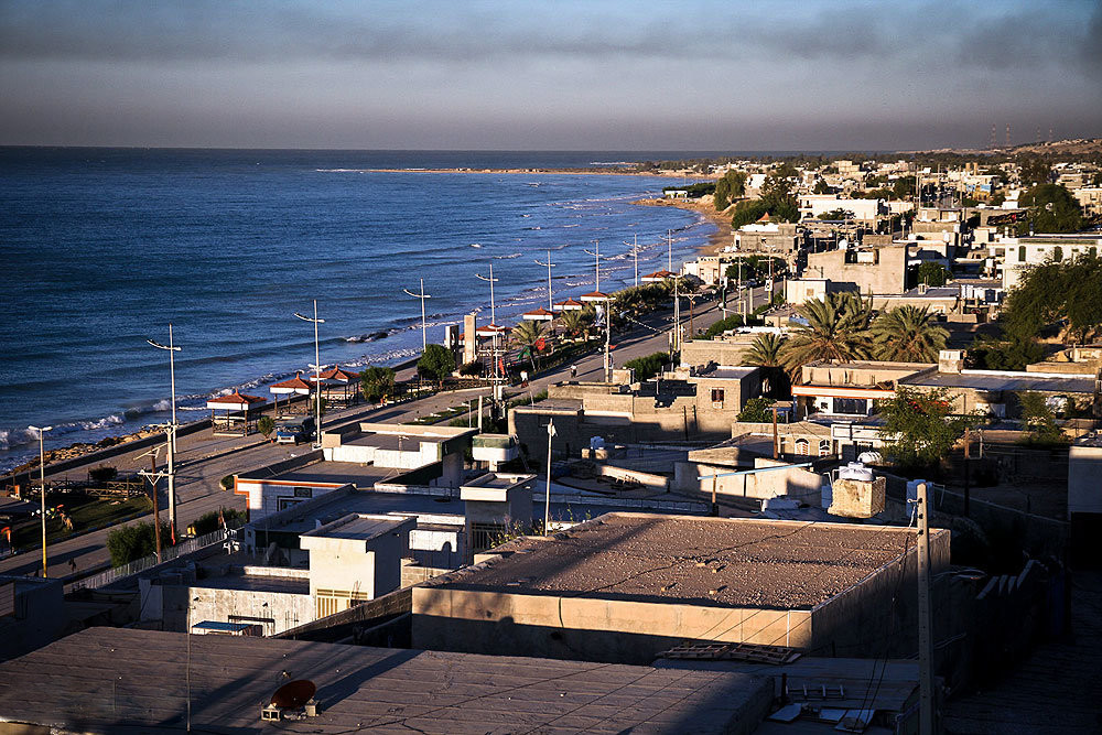


Bandar-e Sīraf, Iran
بندر سیراف
Bandar-e Sīraf is a town of 6,992 people in Bushehr, Iran.
Why visit Bandar-e Sīraf
Townapedia lists 2 museums and landmarks, 1 park or trail, 1 place to eat and 1 place to stay in and around town.
Highlights include Sheikh Nasouris Castle.
Weather in Bandar-e Sīraf
Forecast from MET Norway (CC BY 4.0). Full forecast
About Bandar-e Sīraf
Bandar Siraf (Persian: بندر سیراف) is a city in, and the capital of, Siraf District in Kangan County, Bushehr province, Iran. As the village of Taheri, it was the capital of Taheri Rural District until its capital was transferred to the village of Parak. Taheri was converted to a city in 2005.
From the Wikipedia article Bandar Siraf (this version), under CC BY-SA 4.0.
Museums and landmarks2



Parks, trails and playgrounds1

Restaurants and cafes1

Where to stay1

History
The port was known as Siraf in ancient times. At the time of the Silk Road, most of the commerce towards Asia was performed through Siraf. Several episodes of massive earthquakes and tsunamis damaged and drowned much of the port city, where its ancient quays, moorages, administrative structures, and even boat remains are found today on the sea floor of the Persian Gulf via marine archaeology.
From the History section of Bandar Siraf on Wikipedia, under CC BY-SA 4.0.
Gas and EV charging3
Map of Bandar-e Sīraf
8 places. The map loads OpenStreetMap tiles when you open it.
Getting there and nearby towns
Jam Airport (KNR) is the nearest airport with scheduled flights listed in OpenStreetMap, 17 km away.
- Parak 7 km east, about 7 min by car
- Bandar-e Shīrīnū 14 km east, about 14 min by car
- Bast-e Malakhī 15 km north, about 15 min by car
- Jam 18 km north, about 18 min by car
- Bahārestān 18 km north, about 18 min by car
- Tonbak 18 km northwest, about 18 min by car
- Makū 22 km north, about 22 min by car
- Chāh Kabkān 27 km east, about 27 min by car
- Nakhl-e Taqī 30 km southeast, about 30 min by car
- Galehdār 31 km east, about 31 min by car
Drive times are estimates from straight-line distance, not routes.
Local news
Headlines from INDB.
Reviews, tips and questions
Loading what members have shared...
Sources and licences
- GeoNames (CC BY 4.0): population, coordinates, regions and time zone
- OpenStreetMap contributors (ODbL 1.0): places, airports, map data
- Wikidata (CC0 1.0): elevation, founding date, time zone, website
- Wikimedia Commons (see each image): photos
- Wikipedia (CC BY-SA 4.0): overview and history text
Photo credits
- ساحل بندر سیراف, امین رحمانی (Amin Rahmani), CC BY 4.0
- 3513 قلعه شیخ نصوری سیراف بوشهر, Mehrdad Jamali firouzabadi, CC BY-SA 4.0
- Nasoori castle siraf, Saeed Dehghani, CC BY-SA 4.0
- جاده به خلیخ فارس میرسد - panoramio, matin fattahi, CC BY 3.0
- Very beautiful with high grass plains - panoramio, matin fattahi, CC BY 3.0
- گورهای دسته جمعی سیراف, Adrina1395, CC BY-SA 4.0
- سالن آفی تاتر در مجاورت خلیج فارس - panoramio, matin fattahi, CC BY 3.0
- مجتمع اداری عسلویه منطقه بسیار زیبا و رویایی در کنار خلیج فارس - panoramio, matin fattahi, CC BY 3.0
- Shadow home - panoramio, matin fattahi, CC BY 3.0
- شهر رویایی و بندری زیبا در خلیج فارس - panoramio, matin fattahi, CC BY 3.0
- ایران سرای من است زیبایی های ایران افتخار من است - panoramio, matin fattahi, CC BY 3.0
- چمن در چمن - panoramio, matin fattahi, CC BY 3.0
- Persian golf in iran - panoramio, matin fattahi, CC BY 3.0
- این هم نوعی مسجد به سبک معماری عسلویه - panoramio, matin fattahi, CC BY 3.0
- Asalouyeh in iran persian golf - panoramio, matin fattahi, CC BY 3.0
- Home a persin golf in iran - panoramio, matin fattahi, CC BY 3.0
- Bandar Siraf, Bushehr, Iran - panoramio (1), matin fattahi, CC BY 3.0
- شهر زیبا در کنار خلیج همیشه فارس - panoramio, matin fattahi, CC BY 3.0
- Nature in the Persian Gulf shop lights at night - panoramio, matin fattahi, CC BY 3.0
- بقول محلی ها درخت زبان کتر - panoramio, matin fattahi, CC BY 3.0
- Bandar Siraf, Bushehr, Iran - panoramio, matin fattahi, CC BY 3.0
- ساختمان زیبا دریای زیبا آسمانی زیبا - panoramio, matin fattahi, CC BY 3.0
- فاز 12 عسلویه بندر سیراف - panoramio, matin fattahi, CC BY 3.0
- غروب خورشید در عسلویه - panoramio, matin fattahi, CC BY 3.0
- دود در آسمان پاک - panoramio, matin fattahi, CC BY 3.0
- ساختمان شبیه کله آدم - panoramio, matin fattahi, CC BY 3.0
- کوه زیبا آسمانی زیبا - panoramio, matin fattahi, CC BY 3.0
- فاز 12 عسلویه بندر سیراف و خلیج همیشگی فارس - panoramio, matin fattahi, CC BY 3.0
- Golo bol bol dar iran - panoramio, matin fattahi, CC BY 3.0
- Romantic home in persian golf - panoramio, matin fattahi, CC BY 3.0
- Very nice home in iran asalouyeh - panoramio, matin fattahi, CC BY 3.0
- روح معماری قدیم در بنایی جدید - panoramio, matin fattahi, CC BY 3.0
- ساختمانهای اداری عسلویه - panoramio, matin fattahi, CC BY 3.0
- Very very nice home in ashia - panoramio, matin fattahi, CC BY 3.0
- Nice and nice home - panoramio, matin fattahi, CC BY 3.0


Page built November 8, 2026. Spotted a mistake? Tell us or suggest a place.