Townapedia
حمام مهرآباد و موزه مردم شناسی سهند
حمام مهرآباد و موزه مردم شناسی سهند · Hosein.Kheiryfam, CC BY-SA 4.0
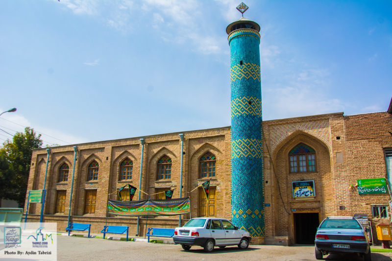
Mehr Abad jami mosque
Mehr Abad jami mosque · aydin tabrizi, CC BY-SA 4.0
حمام مهرآباد و موزه مردم شناسی سهند2
حمام مهرآباد و موزه مردم شناسی سهند2 · Hosein.Kheiryfam, CC BY-SA 4.0
مسجد مهرآباد بناب
مسجد مهرآباد بناب · Maftouhi, CC BY-SA 4.0

Bonāb, Iran

بناب

Bonāb is a town of 85,274 people in East Azerbaijan, Iran.

Loading the weather...
Population85,274 GeoNames
Local nameبناب
Elevation1,288 m 4,226 ft
Time zoneAsia/Tehran
Nearest airportMalek Rahmati Airport (ACP) 6 km

Why visit Bonāb

Townapedia lists 6 museums and landmarks, 16 parks and trails, 20 places to eat, 4 places to stay and 4 attractions in and around town.

Highlights include حمام تاریخی حاج فتح الله, کوچه72ملت, Mellat Park and پارک بانوان کوثر.

About Bonāb

Bonab (Persian: بناب) is a city in the Central District of Bonab County, East Azerbaijan province, Iran, serving as capital of both the county and the district. Bonab is 120 km south of Tabriz (the capital of the province), near Lake Urmia. The city is 150 kilometers from Piranshahr, 270 kilometers from Khalkhal, 350 kilometers from Abhar and 450 kilometers from Parsabad.

From the Wikipedia article Bonab (this version), under CC BY-SA 4.0.

Things to do4

بازار بزرگ میوه و تره بار

Farm and orchard · 1.7 km

خیابان چمران جنوبی, Bonab

Open in Google Maps

بازار خشکبار

Farm and orchard · 1.8 km

بازار خشکبار, Bonab

Open in Google Maps

سینما ارشاد

Cinema and theater · 1.3 km

خیابان چمران جنوبی, Bonab

Open in Google Maps

فرهنگسرای شهرداری بناب

Cinema and theater · 1.3 km

Open in Google Maps

Museums and landmarks6

حمام تاریخی حاج فتح الله

Monument and historic site · 0.9 km

شهیدان صدیقی و نژاد محسن, بناب

Open in Google Maps · Wikipedia

کوچه72ملت

Museum · 1.0 km

رعد ۱, Bonab

Mo-Su 09:00-21:00

Open in Google Maps

مسجد تاریخی مهرآباد بناب

Monument and historic site · 0.6 km

خیابان مطهری, بناب

Open in Google Maps · Wikipedia

موزه مردم شناسی جنوب سهند بناب

Museum · 0.6 km

استاد شهریار شرقی - خرمن کوچه, Bonab

Open in Google Maps · Wikipedia

خانه تاریخی سیف العلما

Museum · 0.7 km

خیابان بهشتی, بناب

Open in Google Maps

کاروانسرای قدیمی

Monument and historic site

Open in Google Maps

Parks, trails and playgrounds16

Mellat Park

Park · 1.2 km

بزرگراه سپهبد قاسم سلیمانی, Bonab

24/7

Open in Google Maps

پارک بانوان کوثر

Park

خیابان طالقانی, بناب

sunrise-sunset

Open in Google Maps

فضای سبز فرهنگ

Park · 1.2 km

خیابان فرهنگ جنوبی, بناب

24/7

Open in Google Maps

فضای سبز

Park · 1.4 km

24/7

Open in Google Maps

استادیوم شهید بهشتی

Sports field and stadium · 2.2 km

بلوار لاله, بناب

Open in Google Maps

باغ بشیر رزمی

Park · 1.6 km

Open in Google Maps · 09148281759

بوستان غنچه

Park · 0.9 km

خیابان کاملو, بناب

Open in Google Maps

پارک ساحلی

Park · 1.7 km

خیابان کاج, Bonab

Open in Google Maps

پارک تک باغ

Park · 1.6 km

Open in Google Maps

پارک شهدای سلامت

Park · 1.6 km

Open in Google Maps

پارک کوثر

Park · 0.6 km

Open in Google Maps

پارک نشاط

Park · 0.9 km

Open in Google Maps

4 more on the map.

Advertisement

Restaurants and cafes20

کبابی گلشهر-رضا کهکشانی

Restaurant · Kebab · 1.5 km

کبابی گلشهر - معروفترین کبابی شهرستان بناب به مدیریت و سر آشپزی برادران کهکشانی - در دو طبقه با ظرفیت پذیرایی بیش از 400 میهمان ، آماده...

بلوار امام خمینی, شهر بناب

Open in Google Maps · +98 914 321 9631

رستوران باغ بهشت

Restaurant · Kebab, Asian, Fish And Chips · 2.4 km

بلوار لاله, بناب

Open in Google Maps

قهوه تلخ بنفشه

Cafe · Coffee Shop

خیابان بنفشه, بناب

Open in Google Maps

کافی شاپ بهار

Cafe · Ice Cream, Pizza, Coffee Shop · 1.4 km

بهار - ورزن, Bonab

Open in Google Maps

بستنی فرد

Ice cream

خیابان مطهری, بناب

Open in Google Maps

بستنی و آبمیوه متین

Ice cream

میدان امام حسین (ع), بناب

Open in Google Maps

بستنی و آبمیوه مهتاب

Ice cream

چهار راه - میدان امام حسین (ع), بناب

Open in Google Maps

بستنی گلشهر

Ice cream · 2.3 km

بلوار پاسداران, Bonab

Open in Google Maps

قهوه یاران

Cafe · 1.5 km

میدان معلم, Bonab

Open in Google Maps

نانوایی علی

Bakery · 1.3 km

صدر ۶ - کبیری, Bonab

Open in Google Maps

نانوایی ناصر

Bakery · 1.3 km

خیابان سپهری, Bonab

Open in Google Maps

آبمیوه و بستنی رز

Ice cream

Open in Google Maps

8 more on the map.

History

Based on the archaeological signs found in old Bonab city explorations, the history of this city dates back six thousand years. Also the discovery of old earthenware and metal ware and signs of urban civilization prove this ancient history. Bonab has 25 registered historical monuments on the list of Iran's national monuments, out of which, 8 are under protection.

There are human-built remains from Urartu Civilization in the Savar Village near Bonab which dates back to 700 BC and Iron Age. Also, Bonab became very prosperous during the Safavid era and the traditional theme of architecture in Bonab pertains to this era.

Iranian archeologists hope a newly discovered tunnel in Bonab, northwest of Iran, is likely to lead them to the legendary city of Shiz, dating back to 7,000 years ago. Shiz is believed to have been one of the most prosperous cities in ancient Persia and historical documents indicate it housed over ten thousands people during its booming days. Experts cannot, however, agree on the geographical location of the city, which is believed to have been older than Susa, southwest of Iran.

From the History section of Bonab on Wikipedia, under CC BY-SA 4.0.

Where to stay4

Churches and places of worship35

  • مسجد تاریخی قرمز

    Place of worship · Shia · 1.2 km

    خیابان کاملو, بناب

    Open in Google Maps · Wikipedia

  • مسجد امام جواد (ع)

    Place of worship · Shia · 1.0 km

    میعاد ۲۸, بناب

    Open in Google Maps

  • مسجد تاریخی زرگران

    Place of worship · Shia · 0.6 km

    خیابان زرگران, بناب

    Open in Google Maps

  • مسجد شیخ

    Place of worship · Shia · 0.8 km

    میدان ستارخان, بناب

    Open in Google Maps

  • مسجد صدیقی

    Place of worship · Shia · 0.9 km

    میعاد ۲۰ - پورامین, بناب

    Open in Google Maps

  • مسجد میراحمد

    Place of worship · Shia · 1.0 km

    میعاد ۲۷, بناب

    Open in Google Maps

  • Enqelab Eslami mosque

    Place of worship · Shia

    خیابان امام خمینی (ره), بناب

    Open in Google Maps

  • مسجد امیر المومنین

    Place of worship · Shia · 1.1 km

    خیابان وحدت شرقی - جارچیلار, بناب

    Open in Google Maps

  • مسجد انجمن

    Place of worship · Shia

    خیابان باهنر, بناب

    Open in Google Maps

  • مسجد پورصادق

    Place of worship · Shia · 0.8 km

    خیابان ملاصدار - مهرآوا آرخی, بناب

    Open in Google Maps

  • مسجد تاریخی جامع میدان

    Place of worship · Shia

    خیابان بهشتی, بناب

    Open in Google Maps

  • مسجد حافظ

    Place of worship · Shia

    خیابان حافظ

    Open in Google Maps

Advertisement

Shopping22

Gas and EV charging10

Schools, colleges and libraries42

  • University of Bonab

    School · 3.2 km

    Open in Google Maps · Wikipedia

  • دبستان شاهد شهید مختاری

    School · 1.0 km

    پردیس ۱۳, بناب

    Open in Google Maps

  • دبیرستان دوره اول پسرانه نمونه دولتی علامه امینی

    School · 1.3 km

    فردوس ۱, Bonab

    Open in Google Maps

  • دبیرستان دوره دوم پسرانه نمونه دولتی ولیعصر (عج)

    School · 1.5 km

    شاهد ۳, بناب

    Open in Google Maps

  • دبیرستان شهید مدرس

    School · 1.0 km

    میعاد ۳۲, بناب

    Open in Google Maps

  • مجتمع استعدادهای درخشان علامه طباطبایی

    School · Shia · 1.2 km

    خیابان فرهنگ جنوبی, بناب

    Open in Google Maps

  • مدرسه راضیه روشنایی

    School · 1.3 km

    بلوار کاملو, بناب

    Open in Google Maps

  • مدرسه روشنایی فر

    School · Shia · 1.7 km

    خیابان سهند, بناب

    Open in Google Maps

  • مدرسه شادروان میرعبداله شریفی

    School · Shia · 2.1 km

    محمدی, Bonab

    Open in Google Maps

  • Public Library

    Library · 1.5 km

    بلوار مدرس, Bonab

    Open in Google Maps

  • دانشکده علوم اسلامی

    School

    خیابان امام خمینی (ره), بناب

    Open in Google Maps

  • دبستان دخترانه غیر انتفاعی قرآن و عترت 2

    School

    خیابان ملاصدرا, بناب

    Open in Google Maps

Advertisement

Healthcare32

  • درمانگاه حکیم بناب

    Clinic and pharmacy

    خیابان دانشجو, بناب

    Open in Google Maps

  • داروخانه دکتر انتظاری

    Clinic and pharmacy

    خیابان مطهری, بناب

    Open in Google Maps

  • داروخانه شبانه‌روزی آذربایجان

    Clinic and pharmacy

    خیابان مطهری, Bonab

    Open in Google Maps

  • درمانگاه پاستور بناب

    Clinic and pharmacy

    خیابان مطهری, بناب

    Open in Google Maps

  • کلینیک شمس

    Clinic and pharmacy

    خیابان دانشجو, بناب

    Open in Google Maps

  • تامین اجتماعی شهرستان بناب

    Clinic and pharmacy · 1.2 km

    تامین اجتماعی, Bonab

    Open in Google Maps

  • گیاه دارویی حکیم تمار(وقاری اصل)

    Clinic and pharmacy

    خیابان بهشتی, بناب

    Open in Google Maps

  • بیمارستان امام خمینی (ره)

    Hospital · 1.6 km

    بزرگراه سپهبد قاسم سلیمانی, بناب

    Open in Google Maps

  • داروخانه باقرزاده

    Clinic and pharmacy

    خیابان باهنر, بناب

    Open in Google Maps

  • داروخانه جالینوس

    Clinic and pharmacy

    خیابان دانشجو, بناب

    Open in Google Maps

  • داروخانه دکتر ببری

    Clinic and pharmacy

    خیابان مطهری, بناب

    Open in Google Maps

  • داروخانه دکتر تقی پور

    Clinic and pharmacy

    خیابان دانشجو, بناب

    Open in Google Maps

Map of Bonāb

191 places. The map loads OpenStreetMap tiles when you open it.

Getting there and nearby towns

Malek Rahmati Airport (ACP) is the nearest airport with scheduled flights listed in OpenStreetMap, 6 km away.

Drive times are estimates from straight-line distance, not routes.

Reviews, tips and questions

Loading what members have shared...

Sources and licences

Photo credits

Page built November 8, 2026. Spotted a mistake? Tell us or suggest a place.






