


Why visit Borgarnes
Townapedia lists 7 museums and landmarks, 3 parks and trails, 14 places to eat, 9 places to stay and 1 attraction in and around town.
Highlights include Borgarfjarðarbrú, The Settlement Center and Skallagrímsgarður.
Weather in Borgarnes
Forecast from MET Norway (CC BY 4.0). Full forecast
About Borgarnes
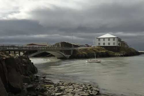
Borgarnes (Icelandic pronunciation: [ˈpɔrkarˌnɛːs]) is a town located on a peninsula at the shore of Borgarfjörður in Iceland and is the largest town in the Borgarbyggð municipality with a population of about 3800 residents. It is a main junction in Iceland and the gateway to the Snaefellsnes National Park. Iceland's capital Reykjavík is 69 kilometers from the center of Borgarnes. The second largest bridge in Iceland, the Borgarfjarðarbrú, connects traffic to and from Reykjavík.
From the Wikipedia article Borgarnes (this version), under CC BY-SA 4.0.
Travel tips from other travellers: Borgarnes on Wikivoyage (CC BY-SA 4.0).
Things to do1

Museums and landmarks7


Parks, trails and playgrounds3



Restaurants and cafes14




BARA Ölstofa Lýðveldisins
Bar and pub
3 Brákarbraut
Th 16:00-23:00; Fr-Sa 14:00-23:00; Su 16:00-23:00
Geirabakarí
Cafe · 0.6 km
6 Digranesgata, Borgarnes
Mo-Th 07:30-16:30; Fr 07:30-17:30; Sa 08:00-16:30; Su,PH 09:00-16:00


2 more on the map.
History
Borgarnes was founded in the late nineteenth-century, in a region that served as the setting of Egil's Saga. The town draws its name from Borg á Mýrum, the farm of Egill Skallagrímsson, the saga's poet-hero protagonist. A museum in Borgarnes, the Settlement Center, is devoted to the region's ties to Egill Skallagrímsson.
From the History section of Borgarnes on Wikipedia, under CC BY-SA 4.0.
Where to stay9
Churches and places of worship1
Shopping4
Gas and EV charging6
Schools, colleges and libraries2
Healthcare3
Map of Borgarnes
50 places. The map loads OpenStreetMap tiles when you open it.
Getting there and nearby towns
Reykjavik Airport (RKV) is the nearest airport with scheduled flights listed in OpenStreetMap, 45 km away.
- Akranes 25 km south, about 25 min by car
- Seltjarnarnes 43 km south, about 43 min by car
- Reykjavík 45 km south, about 45 min by car
- Kópavogur 47 km south, about 47 min by car
- Garðabær 50 km south, about 50 min by car
- Hafnarfjörður 52 km south, about 52 min by car
- Keflavík 67 km southwest, about 1 h by car
- Stykkishólmur 71 km northwest, about 1 h 15 min by car
- Selfoss 81 km southeast, about 1 h 15 min by car
- Grindavík 82 km south, about 1 h 15 min by car
Drive times are estimates from straight-line distance, not routes.
Local news
Headlines from INDB.
Reviews, tips and questions
Loading what members have shared...
Sources and licences
- GeoNames (CC BY 4.0): population, coordinates, regions and time zone
- OpenStreetMap contributors (ODbL 1.0): places, airports, map data
- Openverse (see each image): photos
- Wikidata (CC0 1.0): elevation, founding date, time zone, website, landmarks and historic places
- Wikimedia Commons (see each image): photos
- Wikipedia (CC BY-SA 4.0): overview and history text
Photo credits
- Borgarnes 2023 C, Eysteinn Guðni Guðnason, CC BY-SA 4.0
- Borgarnes - panoramio (5), Patrick Nouhailler's…, CC BY-SA 3.0
- 2009 Borgarnes Stadtkern, Ulrich Latzenhofer, CC BY-SA 2.0
- Borgarnes (23223478029), Lukas von Daeniken from Schweiz, CC BY-SA 2.0
- Borgarnes 2024 0725 184258, Steinninn, CC BY 4.0
- Borgarnes - panoramio (1), Patrick Nouhailler's…, CC BY-SA 3.0
- Borgarnes - panoramio (3), Patrick Nouhailler's…, CC BY-SA 3.0
- Borgarnes - panoramio (2), Patrick Nouhailler's…, CC BY-SA 3.0
- Borgarnes - panoramio, Patrick Nouhailler's…, CC BY-SA 3.0
- 1 borgarnes aerial pano 2017, Chensiyuan, CC BY-SA 4.0
- Borgarnes01, Christian Bickel, CC BY-SA 2.0 de
- Borgarnes, Iceland (7317177196), cjuneau, CC BY 2.0
- Borgarfjarðarbrú 2024 (cropped), Steinninn, CC BY-SA 4.0
- BorgarnesSkallagrímsgarður, Torbenbrinker, CC BY-SA 4.0
- Iceland (19821099530), Sergei Gussev, CC BY 2.0
- 1985 Mitsubishi Galant 1.6 GL (E11A), Mr.choppers, CC BY-SA 3.0
- 1985 Mitsubishi Galant 1.6 GL (E11A) rear, Mr.choppers, CC BY-SA 3.0
- Iceland (19821084450), Sergei Gussev, CC BY 2.0
- 1995 Daihatsu Rocky SE 2.8TD (F78), Mr.choppers, CC BY-SA 3.0
- Range Rover in Iceland (9679801167), Vetatur Fumare, CC BY-SA 2.0
- Ford Ranger Double Cab 4x4, first generation, Mr.choppers, CC BY-SA 3.0
- Dodge Dakota, far from home (9683139872), Vetatur Fumare, CC BY-SA 2.0
- 1994 Mazda 323 Wagon Full Time 4WD front, Mr.choppers, CC BY-SA 3.0
- 1994 Mazda 323 Wagon Full Time 4WD rear, Mr.choppers, CC BY-SA 3.0
- Iceland (19821729410), Sergei Gussev, CC BY 2.0
- Iceland (20009088125), Sergei Gussev, CC BY 2.0
- Iceland (19386487644), Sergei Gussev, CC BY 2.0
- Iceland (19982880816), Sergei Gussev, CC BY 2.0
- Iceland (19822452929), Sergei Gussev, CC BY 2.0
- Bjössaróló árið 2021., Cinquantecinq, CC BY-SA 4.0
- Brákarey 2024 0725 183942, Steinninn, CC BY 4.0
- Brákarey 20240725 183926, Steinninn, CC BY 4.0
- Iceland (19821400618), Sergei Gussev, CC BY 2.0
- Iceland (19821479540), Sergei Gussev, CC BY 2.0
- Iceland (19982894616), Sergei Gussev, CC BY 2.0
- Iceland (19388197773), Sergei Gussev, CC BY 2.0
- Iceland (19982922816), Sergei Gussev, CC BY 2.0
- Iceland (20001438302), Sergei Gussev, CC BY 2.0
- Borganes - panoramio, Patrick Nouhailler's…, CC BY-SA 3.0
- Iceland (19822538079), Sergei Gussev, CC BY 2.0
- Borgarnes, Brákarsund, Ulrich Latzenhofer, CC BY-SA 2.0


Page built November 2, 2026. Spotted a mistake? Tell us or suggest a place.