


Why visit Asuka
Townapedia lists 84 museums and landmarks, 10 parks and trails, 11 places to eat, 3 places to stay and 3 attractions in and around town.
Highlights include Nara Medical University, Mt. Amanokakuyama, Kashihara City Museum of Insects and Nara Prefecture Complex of Man'yo Culture.
Weather in Asuka
Forecast from MET Norway (CC BY 4.0). Full forecast
About Asuka
Asuka (飛鳥; Japanese pronunciation: [a.sɯ̥.ka], locally [aꜜ.sɯ̥.ka]) was the Imperial capital of Japan during the Asuka period (538 – 710 AD), which takes its name from this place. It is located in the present-day village of Asuka, Nara Prefecture.
From the Wikipedia article Asuka, Yamato (this version), under CC BY-SA 4.0.
Travel tips from other travellers: Asuka on Wikivoyage (CC BY-SA 4.0).
Things to do3

Nara Medical University
School · 3.6 km
Higher education institution in Nara Prefecture, Japan


Museums and landmarks84
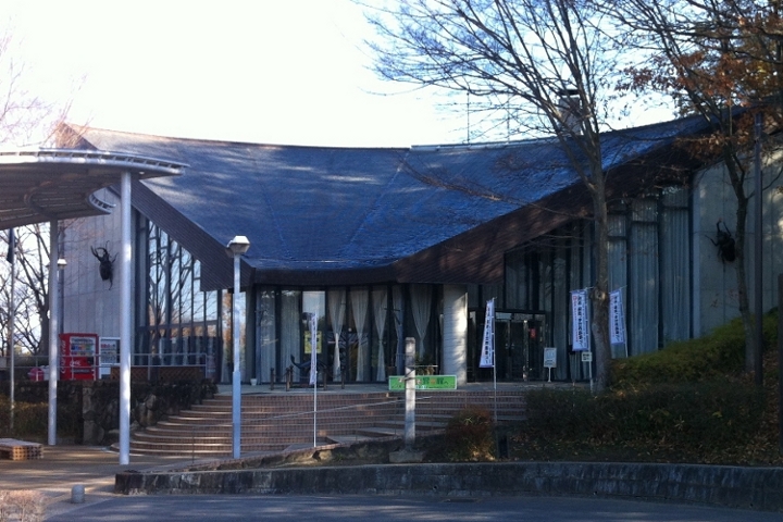

Nara Prefecture Complex of Man'yo Culture
Museum
Museum in Asuka, Nara, Japan
10, 明日香村
10:00-17:00


Asuka
Monument and historic site · 0.7 km
Former imperial capital of Japan

Asuka Inabuchi Palace Site
Monument and historic site · 2.0 km
Archaeological site in Japan


Asuka Pond Workshop Site
Monument and historic site
Archaeological site in Asuka, Nara, Japan

Fujiwara-kyō
Monument and historic site · 2.7 km
Ancient capital of Japan

Inukai Man'yō Memorial Museum
Museum · 1.2 km
Museum in Asuka, Nara, Japan

Moto Yakushi-ji
Monument and historic site · 2.3 km
Former Buddhist temple and archaeological site in Kashihara, Nara Prefecture, Japan

72 more on the map.
Parks, trails and playgrounds10


Asuka Historical National Government Park
Park · 2.3 km
Park in Asuka, Nara, Japan


Restaurants and cafes11




Where to stay3
Churches and places of worship13
Shopping8
Gas and EV charging1
Schools, colleges and libraries9
Healthcare6
Map of Asuka
148 places. The map loads OpenStreetMap tiles when you open it.
Getting there and nearby towns
Osaka Itami Airport (ITM) is the nearest airport with scheduled flights listed in OpenStreetMap, 48 km away.
- Kashihara-shi 4 km northwest, about 4 min by car
- Yamato-Takada 8 km northwest, about 8 min by car
- Tawaramoto 9 km north, about 9 min by car
- Gose 9 km southwest, about 9 min by car
- Tenri 11 km north, about 11 min by car
- Katsuragi 11 km west, about 11 min by car
- Kashiba 12 km northwest, about 12 min by car
- Ōuda-yamaguchi 12 km east, about 12 min by car
- Shimoichi 13 km south, about 13 min by car
- Yamatokōriyama 15 km north, about 15 min by car
Drive times are estimates from straight-line distance, not routes.
Local news
Headlines from INDB.
Reviews, tips and questions
Loading what members have shared...
Sources and licences
- GeoNames (CC BY 4.0): population, coordinates, regions and time zone
- OpenStreetMap contributors (ODbL 1.0): places, airports, map data
- Wikidata (CC0 1.0): elevation, founding date, time zone, website, landmarks and historic places
- Wikimedia Commons (see each image): photos
- Wikipedia (CC BY-SA 4.0): overview and history text
Photo credits
- Asuka Kita Kan-i Post office, Suikotei, CC BY 4.0
- Asuka 20190622153927 (48308573592), inunami, CC BY 2.0
- Asuka-dera Temple (31271333741), David Stanley from Nanaimo, Canada, CC BY 2.0
- Asuka 20190622154151 (48308459676), inunami, CC BY 2.0
- 明日香村飛鳥 飛鳥坐神社 Asukaniimasu-jinja, Asuka 2011.4.17 - panoramio, Nankou Oronain (as36…, CC BY-SA 3.0
- Asuka 20190622154506 (48308458581), inunami, CC BY 2.0
- Asuka-Temple, the Oldest temple of Japan - panoramio, Hikomi Moneru, CC BY 3.0
- Springtime at Asuka ni Masu Jinja, Nankou Oronain (as36…, CC BY-SA 3.0
- Asuka 20190622160605 (48308451236), inunami, CC BY 2.0
- Asuka 20190622160531 (48308565137), inunami, CC BY 2.0
- Asuka 20190622154603 (48308570132), inunami, CC BY 2.0
- Asuka 20190622160739 (48308562137), inunami, CC BY 2.0
- Asuka 20190622160704 (48308563232), inunami, CC BY 2.0
- Asuka 20190622160444 (48308453201), inunami, CC BY 2.0
- Sacred Stone and Shimenawa at Asuka Shrine, inunami, CC BY 2.0
- Asuka 20190622154732 (48308456406), inunami, CC BY 2.0
- 明日香村飛鳥にて 飛鳥川沿いの桃の木 Peach trees along the Asuka-gawa 2012.4.12 - panoramio, Nankou Oronain (as36…, CC BY-SA 3.0
- Asuka 20190622153643 (48308461656), inunami, CC BY 2.0
- Asuka 20190622153023 (48308462496), inunami, CC BY 2.0
- Asuka-Garden 201906c, 8-hachiro, CC BY-SA 4.0
- Asuka-Garden 201906b, 8-hachiro, CC BY-SA 4.0
- Plan of Oharida Palace, Wikiwikiyarou, Public domain
- Nara Medical University (Main gate), 8-hachiro, CC BY-SA 4.0
- Nabunken-asuka, Terumasa, CC BY-SA 3.0
- Asuka Inabuchi Palace site, MChew, CC BY-SA 4.0
- Asuka Mizuochi Site, zenkei-2, Saigen Jiro, CC0
- 飛鳥池工房遺跡 01, GPZ400roman, CC0
- Fujiwara-kyo Kashihara Nara pref Japan04bs5, 663highland, CC BY 2.5
- 犬養万葉記念館 01, Indiana jo, CC BY-SA 4.0
- Motoyakusiji 201909c, 8-hachiro, CC BY-SA 4.0
- Takamatsuzuka 2014, 8-hachiro, CC BY-SA 4.0
- Ishibutai-kofun Asuka Nara pref09n4592, 663highland, CC BY 2.5
- Asuka-dera Asuka Nara pref03n4050, 663highland, CC BY 2.5
- Asuka Kawara no Miya, osakaosaka, CC BY-SA 3.0
- Okadera Asuka Nara pref24n3900, 663highland, CC BY 2.5
- Ishibutai-kofun Asuka Nara pref05n4592, 663highland, CC BY 2.5
- Kaguyama-mt, terumasa, CC BY-SA 3.0
- Asuka village Shotoku jhs, Bakkai, CC BY 3.0
- Tachibanadera autumn, Kumamushi, CC BY-SA 3.0
- Kashihara-City Insectarium, Hiyotchi, CC BY-SA 3.0
- 橿原リハビリテーション病院, にいなめ, CC BY-SA 4.0
- Kashihara city Unebi-higashi elem-sch, Bakkai, CC BY 3.0
- Asuka village Asuka elem-sch, Bakkai, CC BY 3.0
- Man'yō- Museum Entrance, Yanajin33, CC BY-SA 3.0


Page built November 5, 2026. Spotted a mistake? Tell us or suggest a place.