
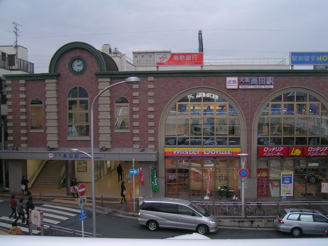


Yamato-Takada, Japan
大和高田市
Yamato-Takada is a town of 61,744 people in Nara, Japan, founded in April 1, 1889.
Why visit Yamato-Takada
Townapedia lists 37 museums and landmarks, 49 parks and trails, 237 places to eat, 12 places to stay and 14 attractions in and around town.
Highlights include Nara Medical University, Bentenza, Asuka and Fujiwara-kyō.
Weather in Yamato-Takada
Forecast from MET Norway (CC BY 4.0). Full forecast
About Yamato-Takada
Yamatotakada (大和高田市, Yamatotakada-shi) is a city located in Nara Prefecture, Japan. As of 31 August 2024, the city had an estimated population of 61,950 in 31312 households, and a population density of 3800 persons per km2. The total area of the city is 16.48 km2 (6.36 sq mi).
From the Wikipedia article Yamatotakada, Nara (this version), under CC BY-SA 4.0.
Things to do14

Nara Medical University
School · 4.2 km
Higher education institution in Nara Prefecture, Japan



2 more on the map.
Museums and landmarks37

Asuka
Monument and historic site · 6.9 km
Former imperial capital of Japan

Fujiwara-kyō
Monument and historic site · 5.5 km
Ancient capital of Japan


Kashiba City Nijyosan Museum
Museum · 5.5 km
Museum in Kashiba, Nara, Japan

Moto Yakushi-ji
Monument and historic site · 5.3 km
Former Buddhist temple and archaeological site in Kashihara, Nara Prefecture, Japan

The Museum, Archaeological Institute of Kashihara, Nara Prefecture
Museum · 4.7 km
Museum in Kashihara, Nara, Japan



Emperor Annei’s Unebiyama-no-Hitsujisaru-no-Mihodo-no-Inoe-no-Misasagi Tomb
Monument and historic site · 3.9 km
25 more on the map.
Parks, trails and playgrounds49

37 more on the map.
Restaurants and cafes237



Beppin-ya
Bar and pub · 3.9 km
Su 17:00-00:00; Mo-Th 17:00-01:00; Fr-Sa 17:00-02:00
225 more on the map.
History
The area of Yamatotakada was part of ancient Yamato Province. Inhabited since the Japanese Paleolithic, the city area nurtured paddy field agriculture in the fertile Nara Basin since ancient times. Numerous large keyhole-type burial mounds (kofun) were constructed in the northwestern part of the city around the 5th century. During the Sengoku period Takada Castle was constructed by the local Takada clan near the site of the current Katashio Elementary School, and the area developed as a castle town. During the Edo Period, it developed into a market town centered around cotton cultivation, which led to the development of spinning and textile industries after the Meiji restoration. The town of Takada was established on April 1, 1889 with the creation of the modern municipalities system. It was elevated to city status on January 1, 1948, and at that time was renamed Yamatotakada (by prepending the former provincial name "Yamato") to avoid duplication with Takada City in Niigata Prefecture (which itself was subsequently renamed). Presently, three other cities in Japan also contain the same two characters that make up "Takada" (高田): Rikuzentakata City in Iwate Prefecture, Akitakata City in Hiroshima Prefecture, and Bungotakada City in Oita Prefecture.
From the History section of Yamatotakada, Nara on Wikipedia, under CC BY-SA 4.0.
Where to stay12
Churches and places of worship47
Shopping58
Gas and EV charging11
Schools, colleges and libraries38
Healthcare64
Map of Yamato-Takada
250 places. The map loads OpenStreetMap tiles when you open it.
Getting there and nearby towns
Osaka Itami Airport (ITM) is the nearest airport with scheduled flights listed in OpenStreetMap, 41 km away.
- Kashihara-shi 4 km east, about 4 min by car
- Habikino 15 km west, about 15 min by car
- Kawachi-Nagano 17 km southwest, about 17 min by car
- Matsubara 19 km west, about 19 min by car
- Ikoma 19 km north, about 19 min by car
- Moriguchi 29 km northwest, about 29 min by car
- Kadoma 29 km northwest, about 29 min by car
- Osaka 30 km northwest, about 30 min by car
- Kishiwada 36 km west, about 36 min by car
- Amagasaki 38 km northwest, about 38 min by car
Drive times are estimates from straight-line distance, not routes.
Local news
Headlines from INDB.
Reviews, tips and questions
Loading what members have shared...
Sources and licences
- GeoNames (CC BY 4.0): population, coordinates, regions and time zone
- OpenStreetMap contributors (ODbL 1.0): places, airports, map data
- Wikidata (CC0 1.0): elevation, founding date, time zone, website, landmarks and historic places
- Wikimedia Commons (see each image): photos
- Wikipedia (CC BY-SA 4.0): overview and history text
Photo credits
- Yamatotakadaeki, M7 at Japanese Wikipedia / Later version(s) were uploaded by Ribbon at Japanese Wikipedia ., CC BY-SA 3.0
- 近鉄大阪線 大和高田駅 Yamato-Takada sta. 2013.8.16 - panoramio, Nankou Oronain (as36…, CC BY-SA 3.0
- Yamato-Takada Sta. - panoramio, Nagono, CC BY-SA 3.0
- 近鉄大阪線 大和高田駅 Yamato-Takada sta. 2013.8.16 - panoramio (1), Nankou Oronain (as36…, CC BY-SA 3.0
- Yamato-Takada Sta. - panoramio (1), Nagono, CC BY-SA 3.0
- Nara Medical University (Main gate), 8-hachiro, CC BY-SA 4.0
- Plan of Oharida Palace, Wikiwikiyarou, Public domain
- Fujiwara-kyo Kashihara Nara pref Japan04bs5, 663highland, CC BY 2.5
- Motoyakusiji 201909c, 8-hachiro, CC BY-SA 4.0
- The Museum,Archaeological Institute of Kashihara,Nara Prefecture, KENPEI, CC BY-SA 3.0
- 今西家, Tokiwokakeru, CC BY-SA 4.0
- Nagao-jinja (Katsuragi, Nara) haiden, KENPEI, CC BY-SA 3.0
- ÆON MALL Kashihara 1, Tokumeigakarinoaoshima, CC0
- Yamatotakada Municipal Hospital, アラツク, CC BY-SA 4.0
- Iwazono Niimasutakumushitama Shrine, KishujiRapid, CC BY-SA 4.0
- Shounenji-temp-hondou, terumasa, CC BY-SA 3.0
- Hasehon-zi in Yamatotakada, Nara Prefecture, Japan, Yokoooziga, CC BY-SA 3.0
- Yamatotakada Municipal Katashio Elementary School, Suikotei, CC BY-SA 4.0
- Imanishi house from the west side, Tokiwokakeru, CC BY-SA 4.0
- 尼寺北廃寺跡 出土品, Saigen Jiro, Public domain
- Kashiba City Goido elementary school, KishujiRapid, CC BY-SA 4.0
- Tsukiyama Kofun (Yamatotakada), funkyu, Saigen Jiro, CC0
- Yamato-Takada city Okanishi elem-sch, Bakkai, CC BY 3.0
- ÆON MALL Kashihara (2), Tokumeigakarinoaoshima, CC BY-SA 4.0
- Yamatotakada Municipal Takada Junior High School, Suikotei, CC BY-SA 4.0
- Kashiba City Kashiba Higashi junior high school, KishujiRapid, CC BY-SA 4.0
- Kashiba City Mamigaoka Higashi elementary school, KishujiRapid, CC BY-SA 4.0
- Dongo Hospital 1, Ebiebi2, CC0
- 天神社 大和高田市三和町 Tenjin-sha shrine 2013.8.16 - panoramio, Nankou Oronain (as36…, CC BY-SA 3.0
- 天神社の狛犬(阿形) 大和高田市三和町 2013.8.16 - panoramio, Nankou Oronain (as36…, CC BY-SA 3.0
- 天神社 大和高田市三和町 Tenjin-sha 2013.8.16 - panoramio, Nankou Oronain (as36…, CC BY-SA 3.0
- 天神社境内の当麻神社 大和高田市三和町 2013.8.16 - panoramio, Nankou Oronain (as36…, CC BY-SA 3.0
- 天神社にて 大和高田市三和町 2013.8.16 - panoramio, Nankou Oronain (as36…, CC BY-SA 3.0
- Takada Station (Nara) ticket gate, Sashimiteishoku, CC0
- Takada Station (Nara) west entrance, Sashimiteishoku, CC0
- 八幡神社 大和高田市本郷町 2013.8.16 - panoramio, Nankou Oronain (as36…, CC BY-SA 3.0
- 高田城址にて 2013.8.16 - panoramio, Nankou Oronain (as36…, CC BY-SA 3.0
- 常光寺 大和高田市旭北町 2013.8.16 - panoramio, Nankou Oronain (as36…, CC BY-SA 3.0
- コミュニティバス「きぼう号」 2013.8.16 - panoramio, Nankou Oronain (as36…, CC BY-SA 3.0
- R165-044, Puchi-masashi, CC BY-SA 4.0


Page built November 5, 2026. Spotted a mistake? Tell us or suggest a place.