


Atsugi, Japan
厚木市
Atsugi is a town of 223,960 people in Kanagawa, Japan, founded in February 1, 1955.
Why visit Atsugi
Townapedia lists 44 museums and landmarks, 115 parks and trails, 218 places to eat, 12 places to stay and 11 attractions in and around town.
Highlights include Ebina Green Center, Joshibi University of Art and Design, 厚木市子ども科学館 and Isehara Hachimandai Stone Age Dwelling Site.
Weather in Atsugi
Forecast from MET Norway (CC BY 4.0). Full forecast
About Atsugi
Atsugi (厚木市, Atsugi-shi; Japanese pronunciation: [ä̀.t͡sɨ́.ɡ̟ʲí(.ɕì), -ŋ̟ʲí(.ɕì)]) is a city in Kanagawa Prefecture, Japan. As of 1 June 2021, the city had an estimated population of 223,960 and a population density of 2400 persons per km2. The total area of the city is 93.83 square kilometres (36.23 sq mi).
From the Wikipedia article Atsugi (this version), under CC BY-SA 4.0.
Travel tips from other travellers: Atsugi on Wikivoyage (CC BY-SA 4.0).
Things to do11


Joshibi University of Art and Design
School · 9.7 km
Higher education institution in Kanagawa Prefecture, Japan
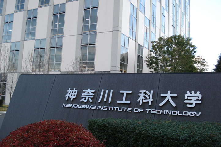
Kanagawa Institute of Technology
School · 5.4 km
Higher education institution in Kanagawa Prefecture, Japan

Keio University Shonan Fujisawa Campus
School · 8.1 km
Higher education institution in Kanagawa Prefecture, Japan
Shoin University
School · 4.8 km
Higher education institution in Kanagawa Prefecture, Japan
Tokyo Jogakkan College
School · 10.9 km
College in Machida, Tokyo, Japan


Museums and landmarks44


Isehara Hachimandai Stone Age Dwelling Site
Monument and historic site · 8.1 km
Archaeological site

Kanzaki Site
Monument and historic site · 5.0 km
Archaeological site in Ayase, Kanagawa, Japan

Katsusaka Site
Monument and historic site · 7.5 km
Archaeological site of the Jomon period in Sagamihara City, Kanagawa Prefecture.

Shimoterao Kanga site
Monument and historic site · 9.2 km
Archaeological site in Japan
Shimoterao Nishikata Site
Monument and historic site · 9.2 km
Archaeological site in Japan
Tanamukaihara Site
Monument and historic site · 9.6 km
Ruins in Sagamihara, Japan

32 more on the map.
Parks, trails and playgrounds115




103 more on the map.
Restaurants and cafes218


Minmin
Restaurant · Asian, 焼肉 · 2.1 km
1, 海老名市
Mo-Th 17:00-23:00; Fr 17:00-23:30; Sa 16:30-23:30; Su,PH 16:30-23:00
restaurantBON
Restaurant
厚木市中町2-4-13 B1F 厚木なかちょう大通り
Th-Tu 10:00-23:00
えびな上野藪そば
Restaurant · Japanese, Noodle, Soba · 1.5 km
17, 海老名市
Mo-Su 11:30-14:30, 17:00-20:00; Th off
206 more on the map.
History
The area around present-day Atsugi city has been inhabited for thousands of years. Archaeologists have found ceramic shards from the Jōmon period at numerous locations in the area. By the Kamakura period, this area part of the Mōri shōen, part of the holdings of Ōe no Hiromoto. His descendants, the Mōri clan later ruled Chōshū domain. During the Kamakura period, the area was also known for its foundry industry for the production of bells for Buddhist temples.
From the History section of Atsugi on Wikipedia, under CC BY-SA 4.0.
Where to stay12
Churches and places of worship62
Shopping29
Gas and EV charging9
Schools, colleges and libraries30
Healthcare46
Map of Atsugi
250 places. The map loads OpenStreetMap tiles when you open it.
Getting there and nearby towns
United States Naval Air Facility Atsugi (NJA) is the nearest airport with scheduled flights listed in OpenStreetMap, 7 km away.
- Yokohama 25 km east, about 25 min by car
- Kawasaki 33 km east, about 33 min by car
- Tokyo 40 km northeast, about 40 min by car
- Kisarazu 51 km east, about 51 min by car
- Matsudo 61 km northeast, about 1 h by car
- Nagareyama 67 km northeast, about 1 h by car
- Narashino 66 km northeast, about 1 h by car
- Kamagaya 68 km northeast, about 1 h 15 min by car
- Chiba 70 km east, about 1 h 15 min by car
- Kashiwa 72 km northeast, about 1 h 15 min by car
Drive times are estimates from straight-line distance, not routes.
Local news
Headlines from INDB.
Reviews, tips and questions
Loading what members have shared...
Sources and licences
- GeoNames (CC BY 4.0): population, coordinates, regions and time zone
- OpenStreetMap contributors (ODbL 1.0): places, airports, map data
- Wikidata (CC0 1.0): elevation, founding date, time zone, website, landmarks and historic places
- Wikimedia Commons (see each image): photos
- Wikipedia (CC BY-SA 4.0): overview and history text
Photo credits
- Atsugi City Hall, ja:user:Hykw-a4, CC BY-SA 3.0
- Atsugi shrine-20161002, Araisyohei, CC BY-SA 4.0
- AtsugiKazan, Haya4, CC BY-SA 4.0
- Atsugi Jinja torii, Tadill, CC BY-SA 3.0
- Atsugi Jinja syagohyo, Tadill, CC BY-SA 3.0
- Atsugi, Kanagawa Prefecture, Japan - panoramio (5), 運転太郎, CC BY 3.0
- Atsugi shrine-20161002 2, Araisyohei, CC BY-SA 4.0
- Atsugi, Kanagawa Prefecture, Japan - panoramio (6), 運転太郎, CC BY 3.0
- Atsugi, Kanagawa Prefecture, Japan - panoramio (7), 運転太郎, CC BY 3.0
- Atsugi, Kanagawa Prefecture, Japan - panoramio (4), 運転太郎, CC BY 3.0
- Atsugi Jinja suijinja, Tadill, CC BY-SA 3.0
- Atsugi Jinja atsugi inarijinja, Tadill, CC BY-SA 3.0
- Atsugi, Kanagawa Prefecture, Japan - panoramio (3), 運転太郎, CC BY 3.0
- Atsugi Higashicho Post Office, 運転太郎, CC BY 3.0
- Atsugi, Kanagawa Prefecture, Japan - panoramio (2), 運転太郎, CC BY 3.0
- Higashicho, Atsugi, Kanagawa Prefecture 243-0001, Japan - panoramio (7), 運転太郎, CC BY 3.0
- Higashicho, Atsugi, Kanagawa Prefecture 243-0001, Japan - panoramio (11), 運転太郎, CC BY 3.0
- Atsugi Jinja agyo, Tadill, CC BY-SA 3.0
- Higashicho, Atsugi, Kanagawa Prefecture 243-0001, Japan - panoramio (9), 運転太郎, CC BY 3.0
- Atsugi Higashicho Post Office 2, 運転太郎, CC BY 3.0
- Higashicho, Atsugi, Kanagawa Prefecture 243-0001, Japan - panoramio (14), 運転太郎, CC BY 3.0
- Atsugi Jinja ungyo, Tadill, CC BY-SA 3.0
- Higashicho, Atsugi, Kanagawa Prefecture 243-0001, Japan - panoramio (16), 運転太郎, CC BY 3.0
- Higashicho, Atsugi, Kanagawa Prefecture 243-0001, Japan - panoramio (8), 運転太郎, CC BY 3.0
- Atsugi Jinja, Tadill, CC BY-SA 3.0
- Higashicho, Atsugi, Kanagawa Prefecture 243-0001, Japan - panoramio (18), 運転太郎, CC BY 3.0
- Higashicho, Atsugi, Kanagawa Prefecture 243-0001, Japan - panoramio (15), 運転太郎, CC BY 3.0
- Higashicho, Atsugi, Kanagawa Prefecture 243-0001, Japan - panoramio (12), 運転太郎, CC BY 3.0
- Higashicho, Atsugi, Kanagawa Prefecture 243-0001, Japan - panoramio (13), 運転太郎, CC BY 3.0
- Higashicho, Atsugi, Kanagawa Prefecture 243-0001, Japan - panoramio (6), 運転太郎, CC BY 3.0
- 1 Chome Nakachō, Atsugi-shi, Kanagawa-ken 243-0018, Japan - panoramio (2), 運転太郎, CC BY 3.0
- 1 Chome Nakachō, Atsugi-shi, Kanagawa-ken 243-0018, Japan - panoramio, 運転太郎, CC BY 3.0
- 1 Chome Nakachō, Atsugi-shi, Kanagawa-ken 243-0018, Japan - panoramio (1), 運転太郎, CC BY 3.0
- 1 Chome Nakachō, Atsugi-shi, Kanagawa-ken 243-0018, Japan - panoramio (9), 運転太郎, CC BY 3.0
- Higashicho, Atsugi, Kanagawa Prefecture 243-0001, Japan - panoramio (19), 運転太郎, CC BY 3.0
- Higashicho, Atsugi, Kanagawa Prefecture 243-0001, Japan - panoramio (17), 運転太郎, CC BY 3.0
- 1 Chome Nakachō, Atsugi-shi, Kanagawa-ken 243-0018, Japan - panoramio (6), 運転太郎, CC BY 3.0
- 1 Chome Nakachō, Atsugi-shi, Kanagawa-ken 243-0018, Japan - panoramio (8), 運転太郎, CC BY 3.0
- Kanagawa Institute of Technology, Catto at Japanese Wikipedia, CC BY-SA 3.0
- Keio University Shonan Fujisawa campus 2015-12-08 (23502820342), yuichi hayakawa from tokyo, japan, CC BY-SA 2.0
- Isehara Hachimandai Stone Age Dwelling Site No.1, 石野瑛, Public domain
- 神崎遺跡, Haya4, CC BY 4.0
- Reconstructed Buildings at Katsusaka Site Park - panoramio, 小林俊通, CC BY-SA 3.0
- Izuminomori Park 01, 椎林 隆夫, CC BY-SA 3.0
- AEON Atsugi 20170214, Kounoichi, CC BY-SA 4.0
- Atsugi city plaza 20161002, Araisyohei, CC BY-SA 4.0
- Atsugi Municipal Hospital, Waka77, CC0
- Aruka-jinja, haiden, Saigen Jiro, CC0
- Ebina General Hospital-2, Waka77, CC0
- 厚木高等学校2, Kozuka Ikuya, CC BY-SA 4.0
- Ebina High School, MJ-bird, CC BY-SA 3.0
- Soji-in 2015-10-04 2, Araisyohei, CC BY-SA 3.0
- Atsugi Central Park ac (1), Asturio Cantabrio, CC BY-SA 4.0


Page built November 4, 2026. Spotted a mistake? Tell us or suggest a place.