
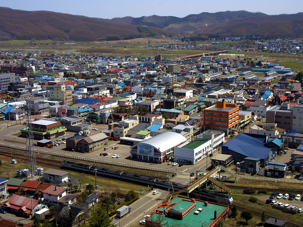


Engaru, Japan
遠軽町
Engaru is a town of 19,241 people in Hokkaido, Japan, founded in April 1, 1934.
Why visit Engaru
Townapedia lists 113 museums and landmarks, 8 parks and trails, 16 places to eat, 3 places to stay and 3 attractions in and around town.
Highlights include ふるさと館JRY, かみゆうべつチューリップ公園 and 太陽の丘えんがる公園.
Weather in Engaru
Forecast from MET Norway (CC BY 4.0). Full forecast
About Engaru
Engaru (遠軽町, Engaru-chō) is a town in the Okhotsk subprefecture of Hokkaido, Japan. The name comes from the Ainu place name Inkar-us-i ("overlook-always doing-place"), meaning a lookout point.
From the Wikipedia article Engaru, Hokkaido (this version), under CC BY-SA 4.0.
Travel tips from other travellers: Engaru on Wikivoyage (CC BY-SA 4.0).
Things to do3


Museums and landmarks113


101 more on the map.
Parks, trails and playgrounds8




Restaurants and cafes16


4 more on the map.
History
1869: Current town area was part of the Wakayama Domain (or Kishū Domain) jurisdiction. There were expanses of plains.
1896: The Church of Christ in Japan established the Hokkaido Comrades Education Association, and planned a Christian university at Engaru.
1897: On 7 May, the first immigrant party of the Hokkaido Comrades Education Association arrived in Engaru, the first party to immigrate at Engaru. But the final construction of the university's plan did not materialize.
1919: The village of Engaru is split off from Kamiyūbetsu (now the town of Yūbetsu).
1925: The village of Ikutahara split off, becoming its own town in 1934.
1946: The villages of Maruseppu (later becoming a town) and Shirataki are split off.
2005: The towns of Engaru, Ikutahara, Maruseppu, and the village of Shirataki merge to form the new town of Engaru.
From the History section of Engaru, Hokkaido on Wikipedia, under CC BY-SA 4.0.
Where to stay3
Churches and places of worship14
Shopping7
Gas and EV charging10
Schools, colleges and libraries18
Engaru Higashi Elementery School Nozomi-no-oka Branch
School · 5.2 km
Healthcare4
Map of Engaru
196 places. The map loads OpenStreetMap tiles when you open it.
Getting there and nearby towns
Monbetsu Airport (MBE) is the nearest airport with scheduled flights listed in OpenStreetMap, 30 km away.
- Kamiyūbetsu Tonden Shigaichi 10 km north, about 10 min by car
- Toppushi 21 km east, about 21 min by car
- Mombetsu 37 km northwest, about 37 min by car
- Kitami 39 km southeast, about 39 min by car
- Motomachi 39 km southeast, about 39 min by car
- Takinoue 41 km northwest, about 41 min by car
- Oketo 41 km south, about 41 min by car
- Sanjūkyūsen 44 km west, about 44 min by car
- Motomachi 51 km southeast, about 51 min by car
- Ozora 52 km east, about 52 min by car
Drive times are estimates from straight-line distance, not routes.
Local news
Headlines from INDB.
Reviews, tips and questions
Loading what members have shared...
Sources and licences
- GeoNames (CC BY 4.0): population, coordinates, regions and time zone
- OpenStreetMap contributors (ODbL 1.0): places, airports, map data
- Wikidata (CC0 1.0): elevation, founding date, time zone, website
- Wikimedia Commons (see each image): photos
- Wikipedia (CC BY-SA 4.0): overview and history text
Photo credits
- Engaru Hokkaido May 2004, Takt tarari, CC BY-SA 3.0
- Engaru-Kosei General Hospital, Yasu ( talk ), CC BY-SA 3.0
- Engaru Municipal Engaru Junior High School, Yasu ( talk ), CC BY-SA 3.0
- Engaru Hokkaido May 2004 2, Takt tarari, CC BY-SA 3.0
- Yubetsu-Furusato-JRY, RJD, CC BY 3.0
- 遠軽高校, 投稿者本人の撮影による, Public domain
- Cosmos area of Taiyo-no-Oka Engaru Park, Tokutotoo, CC BY-SA 4.0
- 国道333号線 - panoramio, Yobito KAYANUMA, CC BY-SA 3.0
- ISS062-E-74852 - View of Earth, Earth Science and Remote Sensing Unit, NASA Johnson Space Center, Public domain
- ISS062-E-74851 - View of Earth, Earth Science and Remote Sensing Unit, NASA Johnson Space Center, Public domain
- ISS018-E-46635 - View of Earth, Earth Science and Remote Sensing Unit , Lyndon B. Johnson Space Center, Public domain
- ISS062-E-74853 - View of Earth, Earth Science and Remote Sensing Unit, NASA Johnson Space Center, Public domain
- ISS062-E-74854 - View of Earth, Earth Science and Remote Sensing Unit, NASA Johnson Space Center, Public domain
- ISS018-E-46636 - View of Earth, Earth Science and Remote Sensing Unit , Lyndon B. Johnson Space Center, Public domain
- 国道333号線 - panoramio - Yobito KAYANUMA, Yobito KAYANUMA, CC BY-SA 3.0
- MonumentOfIkunoStation, Hokko-sha, CC0
- Ikuno Sta. (Sekihoku) Platform Dec.2020, Rory trains, CC BY-SA 4.0


Page built November 5, 2026. Spotted a mistake? Tell us or suggest a place.