


Hida, Japan
飛騨市
Hida is a town of 22,538 people in Gifu, Japan, founded in February 1, 2004.
Why visit Hida
Townapedia lists 62 museums and landmarks, 67 parks and trails, 143 places to eat, 64 places to stay and 22 attractions in and around town.
Highlights include Hida Nagareha Resort, Mt. Oamami, Takayama Jin’ya and Hida Folk Village.
Weather in Hida
Forecast from MET Norway (CC BY 4.0). Full forecast
About Hida
Hida (飛騨市, Hida-shi; Japanese pronunciation: [çí.dä̀, çì.dä́.ɕì]) is a city located in Gifu, Japan. As of 1 December 2017, the city had an estimated population of 24,726, and a population density of 31 persons per km2, in 8,905 households. The total area of the city was 792.53 square kilometres (306.00 sq mi). The official kanji for the city is actually 飛驒, which uses the old rendering of the 騨 character.
From the Wikipedia article Hida, Gifu (this version), under CC BY-SA 4.0.
Travel tips from other travellers: Hida on Wikivoyage (CC BY-SA 4.0).
Things to do22






10 more on the map.
Museums and landmarks62

Takayama Jin’ya
Museum · 13.9 km
Apr 01-Oct 31 Mo-Su 08:45-17:00; Nov 01-Mar 31 Mo-Su 08:45-16:30;...

Hida Folk Village
Museum · 13.8 km
1-590 Kamiokamoto-machi (上岡本町1-590)
Mo-Su 08:30-17:00

Hida Takayama Ukiyoe Gallery Garon
Monument and historic site · 14.0 km
91 Kaminino-machi
Th-Tu 10:00-17:00

Takayama Festival Floats Exhibition Hall
Museum · 13.3 km
Mar 01-Nov 30 Mo-Su 09:00-17:00; Dec 01-Feb 29 Mo-Su 09:00-16:30


Akahogi Tile Kiln Site
Monument and historic site · 10.2 km
Archaeological site in Takayama, Japan



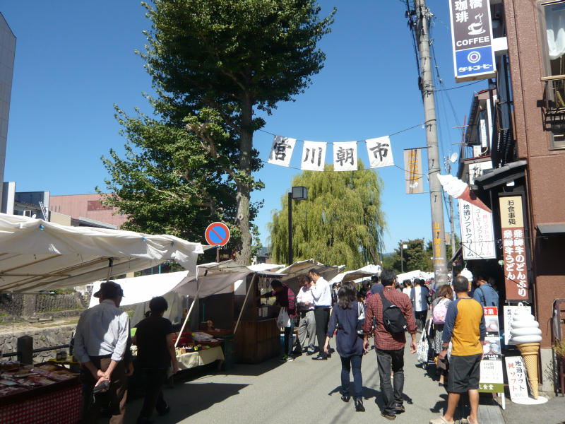
Miyagawa Morning Market
Monument and historic site · 13.5 km
Mo-Su 07:00-12:00

Yoshijima Heritage House
Monument and historic site · 13.3 km
We-Su 09:30-15:30
50 more on the map.
Parks, trails and playgrounds67




見学の丘
Park · 14.6 km
合併記念公園。平成19、20年度に整備。 飛騨エアパークに隣接し、飛行機の離発着が見学できます。星座の説明版があり星空観察もできます。
55 more on the map.
Restaurants and cafes143

EVILTEX
Restaurant · Tex-Mex, Burger · 13.4 km
6-19 Hanasatomachi
Mo,We-Sa 11:30-22:00; Tu off; Su,PH 11:00-21:00
Yamatake-Shoten
Restaurant · Grill, Japanese, Regional · 13.3 km
1 Chome- 7 0 Sowamachi
11:00-14:00, 17:00-21:00; We off


Chitose
Restaurant · Japanese · 13.4 km
6-19 Hanasatomachi, Takayama
We-Mo 11:00-14:50, 17:00-19:20
Tofu Cuisine Noguchiya
Restaurant · Japanese · 13.8 km
35, Takayama
Th-Tu 10:00-15:00
131 more on the map.
History
The area around Hida Furukawa was part of traditional Hida Province. During the Edo period, the whole Hida province was tenryō territory under the direct control of the Tokugawa shogunate. During the post-Meiji restoration whole Japan was under a massive westernization and new reforms, the area was organised into Yoshiki District, Gifu. On July 1, 1889, with the establishment of the modern municipalities system, the town of Furukawa and the villages of Kawai and Miyagawa were created. The modern city of Hida Furukawa was established on February 1, 2004, from the merger of these municipalities with the town of Kamioka. In this region there is always a disambiguation between Hida Furukawa and Hida Takayama or Takayama city. Even though Furukawa has is own municipality, Takayama is a mayor city in the area after Gifu city, and Furukawa is under Hida Takayama's precincts.
From the History section of Hida, Gifu on Wikipedia, under CC BY-SA 4.0.
Where to stay64
Sakura Guest House
Motel and hotel · 13.6 km
3-934-1 Nishinoisshiki-cho, Takayama
Churches and places of worship43
Shopping28
Gas and EV charging11
Schools, colleges and libraries38
Healthcare17
Map of Hida
250 places. The map loads OpenStreetMap tiles when you open it.
Getting there and nearby towns
Toyama Airport (TOY) is the nearest airport with scheduled flights listed in OpenStreetMap, 45 km away.
- Furukawa 2 km southeast, about 2 min by car
- Takayama 14 km southeast, about 14 min by car
- Gero 50 km south, about 50 min by car
- Toyama 51 km north, about 51 min by car
- Gujō 60 km south, about 1 h by car
- Tsubata 61 km northwest, about 1 h by car
- Kanazawa 64 km northwest, about 1 h by car
- Matsutō 62 km northwest, about 1 h by car
- Komatsu 67 km west, about 1 h by car
- Matsumoto 71 km east, about 1 h 15 min by car
Drive times are estimates from straight-line distance, not routes.
Local news
Headlines from INDB.
Reviews, tips and questions
Loading what members have shared...
Sources and licences
- GeoNames (CC BY 4.0): population, coordinates, regions and time zone
- OpenStreetMap contributors (ODbL 1.0): places, airports, map data
- Wikidata (CC0 1.0): elevation, founding date, time zone, website, landmarks and historic places
- Wikimedia Commons (see each image): photos
- Wikipedia (CC BY-SA 4.0): overview and history text
Photo credits
- Central Hida city, 2017, Miyuki Meinaka, CC BY-SA 4.0
- Furukawacho Kamino, Hida, Gifu Prefecture 509-4263, Japan - panoramio (1), kiwa dokokano, CC BY-SA 3.0
- Furukawacho Kamino, Hida, Gifu Prefecture 509-4263, Japan - panoramio, kiwa dokokano, CC BY-SA 3.0
- Street view near Hida City Library 20150123, そらみみ, CC BY-SA 4.0
- Hida City Library 20150123-1, そらみみ, CC BY-SA 4.0
- Gate of Seiganji Temple in Furukawa, Hida, Gifu in winter, そらみみ, CC BY-SA 4.0
- Hida City Library 20150123-2, そらみみ, CC BY-SA 4.0
- Bell tower of Seiganji Temple in Furukawa, Hida, Gifu in winter, そらみみ, CC BY-SA 4.0
- Gifu Prefectural Road No.476 in front of Hida City Office 20150123, そらみみ, CC BY-SA 4.0
- Hida City Office 20150123, そらみみ, CC BY-SA 4.0
- Taishido Hall of Seiganji Temple in Furukawa, Hida, Gifu in winter, そらみみ, CC BY-SA 4.0
- Hondo of Seiganji Temple in Furukawa, Hida, Gifu in winter, そらみみ, CC BY-SA 4.0
- Shonin Mound in Fukukawa, Hida, Gifu 20150123, そらみみ, CC BY-SA 4.0
- Hida Furukawa streets (48519370767), Raita Futo from Tokyo, Japan, CC BY 2.0
- Hida Furukawa streets (48519202876), Raita Futo from Tokyo, Japan, CC BY 2.0
- Hida Furukawa streets (48519370427), Raita Futo from Tokyo, Japan, CC BY 2.0
- Shonindo Hall in Fukukawa, Hida, Gifu 20150123, そらみみ, CC BY-SA 4.0
- Hida-Shimpaku Juniperus chinensis var. sargentii in front of Hidanotakumi Cultural Hall, そらみみ, CC BY-SA 4.0
- Hida-Furukawa Festival Hall in winter, そらみみ, CC BY-SA 4.0
- Setogawa River flowing near Hida-Furukawa Festival Hall, そらみみ, CC BY-SA 4.0
- Hidanotakumi Cultural Hall in winter, そらみみ, CC BY-SA 4.0
- Warehouse in Hida-Furukawa Festival Hall in winter, そらみみ, CC BY-SA 4.0
- Hidanotakumi Cultural Hall and warehouse of Hida-Furukawa Festival Hall, そらみみ, CC BY-SA 4.0
- Ichinomachi Street near Hidanotakumi Cultural Hall 20150123-2, そらみみ, CC BY-SA 4.0
- Ichinomachi Street near Hidanotakumi Cultural Hall 20150123, そらみみ, CC BY-SA 4.0
- Setogawa River flowing behind Enkoji Temple in Fukukawa, Hida, Gifu 3, そらみみ, CC BY-SA 4.0
- Setogawa River flowing behind Enkoji Temple in Fukukawa, Hida, Gifu 2, そらみみ, CC BY-SA 4.0
- Park of Hidanotakumi Cultural Hall covered by snow, そらみみ, CC BY-SA 4.0
- Furukawacho Ichinomachi, Hida, Gifu Prefecture 509-4234, Japan - panoramio (1), YOSHIFUMI OGISO, CC BY-SA 3.0
- Setogawa River flowing behind Enkoji Temple in Fukukawa, Hida, Gifu, そらみみ, CC BY-SA 4.0
- Hida City Cultural Communication Center in winter, Miyuki Meinaka, CC BY-SA 4.0
- Ninomachi Street in Furukawa, Hida, Gifu 20150123-2, そらみみ, CC BY-SA 4.0
- Ninomachi Street in Furukawa, Hida, Gifu 20150123-1, そらみみ, CC BY-SA 4.0
- Akahogi Tile Kiln Site, Takayama, 2019, 大野一将, CC BY-SA 4.0
- Hikari museum, Opqr, CC BY-SA 4.0
- Japan 110416 Takayama 03, Oren Rozen, CC BY-SA 4.0
- Keta wakamiya, Opqr, CC BY-SA 4.0
- JP-Takayama-hida-no-sato-2, Balou46, CC BY-SA 3.0
- Hida Nagareha Snow Resort, Alpsdake, CC BY-SA 4.0
- 千光寺仁王門, 小池 隆, CC BY 3.0
- Miyagawa asaichi, Opqr, CC BY-SA 3.0
- Hida high school, Tomatosukida, CC BY-SA 4.0
- Takayama Kogyo High School, Asasa198, CC BY-SA 3.0
- Takayama-Hie-jinja haiden, nnh, Public domain
- Sakurayama-hachimangu Takayama Gifu pref04s3s3990, 663highland, CC BY 2.5
- Hidakokubunji05ds3200, 663highland, CC BY 2.5
- Takayama Jinya inside view 201706, Wpcpey, CC BY 4.0
- Takayama green hotel, Opqr, CC BY-SA 4.0
- Hida City Library ac (1), Asturio Cantabrio, CC BY-SA 4.0
- Takayama City Library 2020-03 ac (5), Asturio Cantabrio, CC BY-SA 4.0
- Sogen-ji (Takayama, Gifu), Abasaa, Public domain
- Sooin Temple in Takayama, Gifu, そらみみ, CC BY-SA 4.0
- Back view of Hondo of Honkoji Temple 20150123, そらみみ, CC BY-SA 4.0
- Hida Furukawa Enkouji Temple ac, Asturio Cantabrio, CC BY-SA 4.0
- Hida Furukawa Shinshuji Temple ac, Asturio Cantabrio, CC BY-SA 4.0
- Higashiyama-Hakusan-Shrine-Haiden, Naokijp, CC BY-SA 4.0
- 260922 Kusakabe House Takayama Japan02s3, 663highland, CC BY-SA 4.0
- Hida Hotel Plaza, Abasaa, Public domain
- Takayamaouan (An Onsen Ryokan style Hotel), Mj-bird, CC BY-SA 4.0
- 260922 Yoshijima Heritage House Takayama Japan01s3, 663highland, CC BY-SA 4.0
- Mount Ibushi from Meiho Snow Resort s2 - cropped, Alpsdake, CC BY-SA 4.0
- Takayama Festival Float Exhibition Hall , 高山祭屋台会館 - panoramio, z tanuki, CC BY 3.0
- Takayama Showa Kan - panoramio, katsu696, CC BY-SA 3.0


Page built November 5, 2026. Spotted a mistake? Tell us or suggest a place.