


Takayama, Japan
高山市
Takayama is a town of 88,473 people in Gifu, Japan, founded in November 1, 1936.
Why visit Takayama
Townapedia lists 64 museums and landmarks, 72 parks and trails, 141 places to eat, 67 places to stay and 33 attractions in and around town.
Highlights include Hida Funayama Snow Resort Arkopia, Mt. Kurai, Takayama Jin’ya and Hida Folk Village.
Weather in Takayama
Forecast from MET Norway (CC BY 4.0). Full forecast
About Takayama
Takayama (高山市, Takayama-shi; Japanese pronunciation: [tä̀.kä́.jä̀.mä̀, -jä́.mä́(.ɕì)]) is a city located in Gifu Prefecture, Japan. As of 1 September 2025, the city had an estimated population of 81,968 in 36,815 households, and a population density of 41 persons per km2. The total area of the city was 2,177.61 square kilometers (840.78 sq mi) making it the largest city by area in Japan. The high altitude and separation from other areas of Japan kept the area fairly isolated, allowing Takayama to develop its own culture over about a 300-year period.
From the Wikipedia article Takayama, Gifu (this version), under CC BY-SA 4.0.
Travel tips from other travellers: Takayama on Wikivoyage (CC BY-SA 4.0).
Things to do33







21 more on the map.
Museums and landmarks64


Hida Folk Village
Museum · 1.3 km
1-590 Kamiokamoto-machi (上岡本町1-590)
Mo-Su 08:30-17:00

Hida Takayama Ukiyoe Gallery Garon
Monument and historic site · 1.2 km
91 Kaminino-machi
Th-Tu 10:00-17:00

Takayama Festival Floats Exhibition Hall
Museum · 1.9 km
Mar 01-Nov 30 Mo-Su 09:00-17:00; Dec 01-Feb 29 Mo-Su 09:00-16:30


Akahogi Tile Kiln Site
Monument and historic site · 4.1 km
Archaeological site in Takayama, Japan

Dōnosora Site
Monument and historic site · 9.3 km
Archaeological site in Takayama, Chūbu, Japan



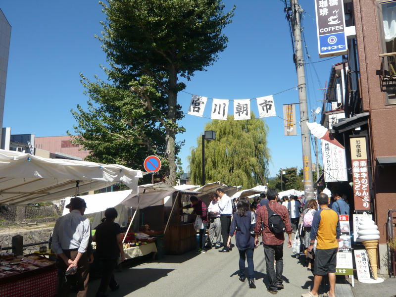
Miyagawa Morning Market
Monument and historic site · 1.4 km
Mo-Su 07:00-12:00
52 more on the map.
Parks, trails and playgrounds72





60 more on the map.
Restaurants and cafes141

EVILTEX
Restaurant · Tex-Mex, Burger · 1.1 km
6-19 Hanasatomachi
Mo,We-Sa 11:30-22:00; Tu off; Su,PH 11:00-21:00
Yamatake-Shoten
Restaurant · Grill, Japanese, Regional · 1.3 km
1 Chome- 7 0 Sowamachi
11:00-14:00, 17:00-21:00; We off


Chitose
Restaurant · Japanese · 1.1 km
6-19 Hanasatomachi, Takayama
We-Mo 11:00-14:50, 17:00-19:20
Tofu Cuisine Noguchiya
Restaurant · Japanese · 1.3 km
35, Takayama
Th-Tu 10:00-15:00
129 more on the map.
History
The area around Takayama was part of traditional Hida Province and was settled as far back as the Jōmon period. During the Sengoku period, Kanamori Nagachika ruled the area from Takayama Castle and the town of Takayama developed as a castle town. During the Edo period, the area was tenryō under the direct control of the Tokugawa shogunate. In the post-Meiji Restoration cadastral reforms, Ōno District in Gifu prefecture was created, and the town of Takayama was established in 1889 with the creation of the modern municipalities system. At the time, it was the most populous municipality in Gifu Prefecture. On November 1, 1936, Takayama merged with the town of Onada, forming the city of Takayama. Takayama annexed the village of Josue in 1943 and the village of Ohachiga in 1955. On February 1, 2005, the town of Kuguno and the villages of Asahi, Kiyomi, Miya, Nyūkawa, Shōkawa, and Takane (all from Ōno District), the town of Kokufu, and the village of Kamitakara (both from Yoshiki District) were absorbed to create the expanded city of Takayama. This made Takayama both the largest city and largest municipality in Japan by area.
From the History section of Takayama, Gifu on Wikipedia, under CC BY-SA 4.0.
Where to stay67
Churches and places of worship32
Shopping28
Gas and EV charging12
Schools, colleges and libraries43
Healthcare19
Map of Takayama
250 places. The map loads OpenStreetMap tiles when you open it.
Getting there and nearby towns
Toyama Airport (TOY) is the nearest airport with scheduled flights listed in OpenStreetMap, 58 km away.
- Gero 37 km south, about 37 min by car
- Toyama 63 km north, about 1 h by car
- Matsumoto 65 km east, about 1 h by car
- Matsutō 75 km northwest, about 1 h 15 min by car
- Yaotsu 75 km south, about 1 h 15 min by car
- Tsubata 75 km northwest, about 1 h 15 min by car
- Kanazawa 77 km northwest, about 1 h 15 min by car
- Komatsu 78 km northwest, about 1 h 15 min by car
- Kani 83 km south, about 1 h 30 min by car
- Kakamigahara 87 km southwest, about 1 h 30 min by car
Drive times are estimates from straight-line distance, not routes.
Local news
Headlines from INDB.
Reviews, tips and questions
Loading what members have shared...
Sources and licences
- GeoNames (CC BY 4.0): population, coordinates, regions and time zone
- OpenStreetMap contributors (ODbL 1.0): places, airports, map data
- Wikidata (CC0 1.0): elevation, founding date, time zone, website, landmarks and historic places
- Wikimedia Commons (see each image): photos
- Wikipedia (CC BY-SA 4.0): overview and history text
Photo credits
- Takayama (15485428565), Felix Filnkoessl, CC BY 2.0
- Takayama Green Hotel 高山格林旅店 - panoramio, lienyuan lee, CC BY 3.0
- Green Hotel Takayama 高山格林飯店 - panoramio, lienyuan lee, CC BY 3.0
- HOTEL takayama-ouan - panoramio, katsu696, CC BY-SA 3.0
- Matsumoto heritage house, Takayama, 2022, 大野 一将, CC BY-SA 4.0
- Japan Nation Route 158 in front of Zenkoji Temple in Takayama, Gifu, そらみみ, CC BY-SA 4.0
- Takayama, Part III - Takayama6369, lumoplank, CC0
- Takayama, Part II - Takayama6392, lumoplank, CC0
- Takayama, Part III - Takayama6367, lumoplank, CC0
- Takayama, Part I - Takayama6377, lumoplank, CC0
- Takayama, Part I - Takayama6379, lumoplank, CC0
- Takayama, Part I - Takayama6382, lumoplank, CC0
- Takayama, Part III - Takayama6359, lumoplank, CC0
- Takayama, Part III - Takayama6358, lumoplank, CC0
- South Takayama Station - panoramio, katsu696, CC BY-SA 3.0
- Zenkoji Temple in Takayama, Gifu 20150123, そらみみ, CC BY-SA 4.0
- 2024-10-27 Takayama 10, Alexkom000, CC BY 4.0
- Hachikenmachi, Takayama, Gifu Prefecture 506-0012, Japan - panoramio (2), ESU, CC BY 3.0
- Hachikenmachi, Takayama, Gifu Prefecture 506-0012, Japan - panoramio, ESU, CC BY 3.0
- 2024-10-27 Takayama 09, Alexkom000, CC BY 4.0
- Takayama conductors' station, Miyuki Meinaka, CC BY-SA 4.0
- Akahogi Tile Kiln Site, Takayama, 2019, 大野一将, CC BY-SA 4.0
- Pit-house of Dōnosora site, Alpsdake, CC BY-SA 4.0
- Hikari museum, Opqr, CC BY-SA 4.0
- Japan 110416 Takayama 03, Oren Rozen, CC BY-SA 4.0
- Keta wakamiya, Opqr, CC BY-SA 4.0
- JP-Takayama-hida-no-sato-2, Balou46, CC BY-SA 3.0
- Mount Kurai from south 2011-02-20, Alpsdake, CC0
- Hida Funayama Snow Resort Arkopia, Alpsdake, CC BY-SA 4.0
- 千光寺仁王門, 小池 隆, CC BY 3.0
- Miyagawa asaichi, Opqr, CC BY-SA 3.0
- Hida high school, Tomatosukida, CC BY-SA 4.0
- Takayama Kogyo High School, Asasa198, CC BY-SA 3.0
- Takayama-Hie-jinja haiden, nnh, Public domain
- Sakurayama-hachimangu Takayama Gifu pref04s3s3990, 663highland, CC BY 2.5
- Ena shrine takayama, Opqr, CC BY-SA 4.0
- Hidakokubunji05ds3200, 663highland, CC BY 2.5
- Takayama Jinya inside view 201706, Wpcpey, CC BY 4.0
- Takayama green hotel, Opqr, CC BY-SA 4.0
- Ontakesan from Kuraiyama 2005-3-21, Alpsdake, Public domain
- Hida City Library ac (1), Asturio Cantabrio, CC BY-SA 4.0
- Takayama City Library 2020-03 ac (5), Asturio Cantabrio, CC BY-SA 4.0
- Sooin Temple in Takayama, Gifu, そらみみ, CC BY-SA 4.0
- Back view of Hondo of Honkoji Temple 20150123, そらみみ, CC BY-SA 4.0
- Hida Furukawa Enkouji Temple ac, Asturio Cantabrio, CC BY-SA 4.0
- Hida Furukawa Shinshuji Temple ac, Asturio Cantabrio, CC BY-SA 4.0
- Takayama City Kuguno Junior high school, Alpsdake, CC BY-SA 4.0
- Higashiyama-Hakusan-Shrine-Haiden, Naokijp, CC BY-SA 4.0
- 260922 Kusakabe House Takayama Japan02s3, 663highland, CC BY-SA 4.0
- Hida Hotel Plaza, Abasaa, Public domain
- Takayamaouan (An Onsen Ryokan style Hotel), Mj-bird, CC BY-SA 4.0
- Mount Ibushi from Meiho Snow Resort s2 - cropped, Alpsdake, CC BY-SA 4.0
- Takayama Festival Float Exhibition Hall , 高山祭屋台会館 - panoramio, z tanuki, CC BY 3.0
- Takayama Showa Kan - panoramio, katsu696, CC BY-SA 3.0


Page built November 4, 2026. Spotted a mistake? Tell us or suggest a place.