


Why visit Hirao
Townapedia lists 14 museums and landmarks, 3 parks and trails, 31 places to eat, 22 places to stay and 2 attractions in and around town.
Highlights include Sano ruins, 佐山忠輝の碑 and Jigokudani Monkey Park.
Weather in Hirao
Forecast from MET Norway (CC BY 4.0). Full forecast
Things to do2


Museums and landmarks14



2 more on the map.
Parks, trails and playgrounds3
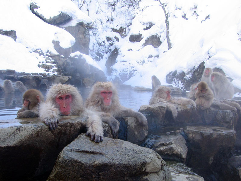


Jigokudani Monkey Park
Park · 4.2 km
Hot springs area with large population of wild snow monkeys


Restaurants and cafes31

Archie's
Restaurant · American, Burger · 0.6 km
Mo-Tu 12:00-20:00; Su 12:00-18:00; Fr-Sa 12:00-21:00

CHAMISE
Cafe · Coffee Shop · 0.6 km
Tu,We,Sa 15:00-22:00; Fr 18:00-22:00; Su 12:00-16:00; Mo,Th off
19 more on the map.
Where to stay22
Churches and places of worship5
Shopping7
Gas and EV charging1
Schools, colleges and libraries2
Map of Hirao
87 places. The map loads OpenStreetMap tiles when you open it.
Getting there and nearby towns
Shinshu-Matsumoto Airport (MMJ) is the nearest airport with scheduled flights listed in OpenStreetMap, 78 km away.
- Nakano 5 km west, about 5 min by car
- Obuse 11 km southwest, about 11 min by car
- Iiyama 12 km north, about 12 min by car
- Suzaka 14 km southwest, about 14 min by car
- Myoko 34 km northwest, about 34 min by car
- Sakaki 38 km southwest, about 38 min by car
- Chikuma 38 km southwest, about 38 min by car
- Ueda 40 km south, about 40 min by car
- Higashiagatsuma 41 km southeast, about 41 min by car
- Jōetsu 48 km north, about 48 min by car
Drive times are estimates from straight-line distance, not routes.
Local news
Headlines from INDB.
Reviews, tips and questions
Loading what members have shared...
Sources and licences
- GeoNames (CC BY 4.0): population, coordinates, regions and time zone
- OpenStreetMap contributors (ODbL 1.0): places, airports, map data
- Wikidata (CC0 1.0): elevation, founding date, time zone, website, landmarks and historic places
- Wikimedia Commons (see each image): photos
Photo credits
- Hirao, Yamanouchi, Shimotakai District, Nagano Prefecture 381-0401, Japan - panoramio (2), ESU, CC BY 3.0
- Hirao, Yamanouchi, Shimotakai District, Nagano Prefecture 381-0401, Japan - panoramio (4), ESU, CC BY 3.0
- Hirao, Yamanouchi, Shimotakai District, Nagano Prefecture 381-0401, Japan - panoramio (1), ESU, CC BY 3.0
- Hirao, Yamanouchi, Shimotakai District, Nagano Prefecture 381-0401, Japan - panoramio (3), ESU, CC BY 3.0
- Hirao, Yamanouchi, Shimotakai District, Nagano Prefecture 381-0401, Japan - panoramio (5), ESU, CC BY 3.0
- Hirao, Yamanouchi, Shimotakai District, Nagano Prefecture 381-0401, Japan - panoramio, ESU, CC BY 3.0
- Jigokudani hotspring in Nagano Japan 001, Yosemite, CC BY-SA 3.0
- Yamanouchi Town Yamanouchi Junior High School, Suikotei, CC BY 4.0
- 佐山忠輝の碑, Haya4, CC BY 4.0
- Yamanouchi, Japan (Unsplash), Steven Diaz stevendiazphoto, CC0
- 湯田中駅 ホーム北端 - panoramio, クハ419-5, CC BY-SA 3.0
- 湯田中駅 旧駅舎と足湯 - panoramio, クハ419-5, CC BY-SA 3.0
- Nagano Dentsu Yudanaka sta. , 長野電鉄 湯田中駅 - panoramio (1), z tanuki, CC BY 3.0
- 湯田中 - Yudanaka (33818318128), tsuruta yosuke from Nagano, Japan, CC BY 2.0
- Nagano Dentsu Yudanaka sta. , 長野電鉄 湯田中駅 - panoramio, z tanuki, CC BY 3.0
- Time table for Monky Park - panoramio, z tanuki, CC BY 3.0
- Heritage limited express 2010-03-28, Nick Richards, CC BY-SA 2.0
- 楓の湯 - panoramio, くろふね, CC BY 3.0
- 湯田中駅 旧駅舎 - panoramio, クハ419-5, CC BY-SA 3.0
- 湯田中駅 - panoramio, くろふね, CC BY 3.0
- 湯田中駅 終点 - panoramio, クハ419-5, CC BY-SA 3.0
- Nagaden MoHa2100 Inside, キャンター, CC BY-SA 4.0
- Nagano Dentesu Yudanaka sta. , 長野電鉄 湯田中駅 - panoramio (1), z tanuki, CC BY 3.0
- Yudanaka station building, Niiryoku2910, CC BY-SA 4.0
- Nagaden Hire Yudanaka Branch, Kazakura, CC BY-SA 4.0
- Nagano Dentesu Yudanaka sta. , 長野電鉄 湯田中駅 - panoramio, z tanuki, CC BY 3.0
- Nagano Dentsu Yudanaka sta. , 長野電鉄 湯田中駅 - panoramio (2), z tanuki, CC BY 3.0
- Front of Yudanaka sta. , 湯田中駅前 - panoramio, z tanuki, CC BY 3.0
- Nagano Dentsu Yudanaka sta. , 長野電鉄 湯田中駅 - panoramio (3), z tanuki, CC BY 3.0
- 湯田中温泉街 - panoramio, くろふね, CC BY 3.0
- 2024-10-23 Street lights in Yamanochi, Alexkom000, CC BY 4.0
- Yudanaka Onsen Yukeburi no Ashiyu, Suikotei, CC BY 4.0
- 2024-10-22 Yomase river in Yamanouchi, Alexkom000, CC BY 4.0
- 西日に光る湯田中の街と遅咲きの桜 - panoramio, ESU, CC BY 3.0
- 2023-10-22 Yamanouchi, Alexkom000, CC BY 4.0
- 上条駅 - panoramio, くろふね, CC BY 3.0
- Nagaden Kamijo Station 2017, キャンター, CC BY-SA 3.0
- 長野電鉄1000系S2編成, Kznrhsd, CC0
- Nageden 3500 series passes through apple orchards in spring, Kznrhsd, CC0
- Nageden 3000 series passes through apple orchards in spring, Kznrhsd, CC0


Page built November 5, 2026. Spotted a mistake? Tell us or suggest a place.