




Nakano, Japan
中野市
Nakano is a town of 42,664 people in Nagano, Japan, founded in July 1, 1954.
Why visit Nakano
Townapedia lists 36 museums and landmarks, 20 parks and trails, 208 places to eat, 52 places to stay and 16 attractions in and around town.
Highlights include Jigokudani Monkey Park, The Cupid of Romance, 中野市立博物館 and Hokusai Museum.
Weather in Nakano
Forecast from MET Norway (CC BY 4.0). Full forecast
About Nakano
Nakano (中野市, Nakano-shi; Japanese pronunciation: [nä̀.kä́.nó̞(.ɕì)]) is a city located in Nagano Prefecture, Japan. As of 1 March 2019, the city had an estimated population of 42,664 in 15649 households, and a population density of 380 persons per km2. The total area of the city is 112.18 square kilometres (43.31 sq mi).
From the Wikipedia article Nakano, Nagano (this version), under CC BY-SA 4.0.
Things to do16
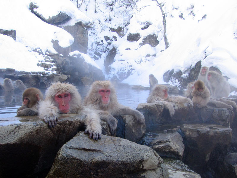
Jigokudani Monkey Park
Zoo and aquarium · 8.8 km
Hot springs area with large population of wild snow monkeys
Apr-Oct Mo-Su 08:30-17:00; Nov-Mar Mo-Su 09:00-16:00






4 more on the map.
Museums and landmarks36






24 more on the map.
Parks, trails and playgrounds20




8 more on the map.
Restaurants and cafes208


Rausuan Soba
Restaurant · Noodles, Japanese · 7.4 km
Soba restaurant
Mo-Su 11:30-15:00
The Farmhouse
Restaurant · Japanese · 7.1 km
1403-2
We-Mo 12:00-23:00
Nagano-Donabe Ramen Takesan
Restaurant · Noodle, Ramen · 7.3 km
1, 小布施町
Mo-We,Fr-Su 10:00-14:30,17:00-21:00
Archie's
Restaurant · American, Burger · 4.4 km
Mo-Tu 12:00-20:00; Su 12:00-18:00; Fr-Sa 12:00-21:00

CHAMISE
Cafe · Coffee Shop · 4.5 km
Tu,We,Sa 15:00-22:00; Fr 18:00-22:00; Su 12:00-16:00; Mo,Th off
Noodle shop SUKEYA Japan the head quarters
Restaurant · Noodle, Ramen · 1.6 km
Mo-Su 11:30-21:00
196 more on the map.
History
The area of present-day Nakano was part of ancient Shinano Province. The area was part of the tenryō (direct holdings) of the Tokugawa shogunate during the Edo period and was administered from Nakano jin'ya. Nakano was the capital of "Nakano Prefecture" from 1870 to 1871, when it was merged with Nagano Prefecture. The modern town of Nakano was established on April 1, 1889 with the establishment of the municipalities system. It was elevated to city status on July 1, 1955 by the merger of the town with neighboring villages of Hino, Entoku, Nagaoka, Hiraoka, Takaoka, Shinano, and Yamato.
On April 1, 2005, the village of Toyota (from Shimominochi District) was merged into Nakano.
From the History section of Nakano, Nagano on Wikipedia, under CC BY-SA 4.0.
Where to stay52
Churches and places of worship52
Shopping29
Gas and EV charging16
Schools, colleges and libraries24
Healthcare21
Map of Nakano
250 places. The map loads OpenStreetMap tiles when you open it.
Getting there and nearby towns
Shinshu-Matsumoto Airport (MMJ) is the nearest airport with scheduled flights listed in OpenStreetMap, 76 km away.
- Obuse 8 km southwest, about 8 min by car
- Suzaka 12 km south, about 12 min by car
- Sakaki 36 km southwest, about 36 min by car
- Ueda 39 km south, about 39 min by car
- Jōetsu 46 km north, about 46 min by car
- Higashiagatsuma 45 km southeast, about 45 min by car
- Nakanojō 46 km southeast, about 46 min by car
- Ōmachi 53 km southwest, about 53 min by car
- Shiozawa 53 km northeast, about 53 min by car
- Tōkamachi 56 km northeast, about 56 min by car
Drive times are estimates from straight-line distance, not routes.
Local news
Headlines from INDB.
Reviews, tips and questions
Loading what members have shared...
Sources and licences
- GeoNames (CC BY 4.0): population, coordinates, regions and time zone
- OpenStreetMap contributors (ODbL 1.0): places, airports, map data
- Wikidata (CC0 1.0): elevation, founding date, time zone, website, landmarks and historic places
- Wikimedia Commons (see each image): photos
- Wikipedia (CC BY-SA 4.0): overview and history text
Photo credits
- Nakano city hall, Altomarina, CC BY-SA 3.0
- Nakano Jin'ya, photo: Qurren ( talk ) Taken with Canon IXY 10S (Digital IXUS 210), CC BY-SA 3.0
- Hachijuni Bank Nakano Branch & Nakanonishi Branch 20251129, Suikotei, CC BY 4.0
- Jigokudani hotspring in Nagano Japan 001, Yosemite, CC BY-SA 3.0
- Issakanzenkei, Takayamaissakan, CC BY-SA 3.0
- Hokushin General Hospital, アラツク, CC BY-SA 4.0
- Ganshoin Hondo 01, Tawashi2006, CC BY-SA 3.0
- Mt.Kosha, Ski Mania, Public domain
- Library of Nakano City in Nagano Pref enterance, 香港鉄人, CC BY-SA 4.0
- Nakayama Shinpei Memorial Hall, photo: Qurren ( talk ) Taken with Canon IXY 10S (Digital IXUS 210), CC BY-SA 3.0
- 一本木公園(バラ公園), 黒崎一男, CC BY-SA 4.0
- 高梨館跡公園1, 黒崎一男, CC BY-SA 4.0
- 佐山忠輝の碑, Haya4, CC BY 4.0
- Nakano City Museum, gaikan, Saigen Jiro, CC0
- Hokusai Museum, キャンター, CC BY-SA 4.0
- Former Nakano Town Office, gaikan, Saigen Jiro, CC0
- 高梨館跡公園, 黒崎一男, CC BY-SA 4.0
- 高社中学校(2020-3-27), 黒崎一男, CC BY-SA 4.0
- 中野市立日野小学校(2020-4-1), 黒崎一男, CC BY-SA 4.0
- 中野市立延徳小学校(2020-4-1), 黒崎一男, CC BY-SA 4.0
- 中野市立高丘小学校(2020-4-1), 黒崎一男, CC BY-SA 4.0
- 日本土人形資料館全景(2020-2-6), 黒崎一男, CC BY-SA 4.0
- 武水穂神社, 黒崎一男, CC BY-SA 4.0
- 王日神社, 黒崎一男, CC BY-SA 4.0
- 袋屋美術館(2020-2-21), 黒崎一男, CC BY-SA 4.0
- 信州中野銅石版画ミュージアム, 黒崎一男, CC BY-SA 4.0
- 中野市立南宮中学校(2020-3-30), 黒崎一男, CC BY-SA 4.0
- 中野市立中野平中学校(2020-3-30), 黒崎一男, CC BY-SA 4.0
- 中野市立中野小学校(2020-3-30) (2), 黒崎一男, CC BY-SA 4.0
- 中野市立平野小学校(2020-3-30), 黒崎一男, CC BY-SA 4.0
- 中野市立中野小学校(2020-3-30), 黒崎一男, CC BY-SA 4.0
- 如法寺大悲閣観音堂2, 黒崎一男, CC BY-SA 4.0
- 袋屋美術館展示室(2020-2-21), 黒崎一男, CC BY-SA 4.0
- 信州中野駅 - panoramio (1), くろふね, CC BY 3.0
- NER 3000 Series outside door button, キャンター, CC BY 3.0
- NER 3000 Series inside door button, キャンター, CC BY 3.0
- Monhan (Monster Hunter) Express , 長野電鉄 モンハン特急 - panoramio, z tanuki, CC BY 3.0
- 信州中野駅 - panoramio, くろふね, CC BY 3.0
- 創作土人形工房 まちなか交流の家展示(2020-2-21), 黒崎一男, CC BY-SA 4.0
- 創作土人形工房 まちなか交流の家(2020-2-21), 黒崎一男, CC BY-SA 4.0


Page built November 5, 2026. Spotted a mistake? Tell us or suggest a place.