


Katsuyama, Japan
勝山市
Katsuyama is a town of 27,088 people in Fukui, Japan, founded in September 1, 1954.
Why visit Katsuyama
Townapedia lists 62 museums and landmarks, 15 parks and trails, 83 places to eat, 21 places to stay and 19 attractions in and around town.
Highlights include Mt. Dainichi, Mt. Johoji, Ōno Castle and Echizen Ōno Castle.
Weather in Katsuyama
Forecast from MET Norway (CC BY 4.0). Full forecast
About Katsuyama
Katsuyama (勝山市, Katsuyama-shi) is a city located in Fukui Prefecture, Japan. As of 31 January 2026, the city has an estimated population of 20,653 in 7,971 households, and a population density of 81 persons per km2. The total area of the city was 253.88 square kilometres (98.02 sq mi). Katsuyama was the ninth-best ranking city in a ranking that compared health and sanitation in cities around the world published in April 2007.
From the Wikipedia article Katsuyama, Fukui (this version), under CC BY-SA 4.0.
Travel tips from other travellers: Katsuyama on Wikivoyage (CC BY-SA 4.0).
Things to do19







7 more on the map.
Museums and landmarks62





50 more on the map.
Parks, trails and playgrounds15




3 more on the map.
Restaurants and cafes83


71 more on the map.
History
Katsuyama is part of ancient Echizen Province. During the Sengoku period, Katsuyama Castle was the stronghold of Shibata Katsuyasu, a relative of Shibata Katsuie. During the Edo period, the area was divided between the holdings of Echizen-Katsuyama Domain, Fukui Domain, Ōno Domain, and Gujō Domain. Following the Meiji restoration, it was organised into part of Ōno District in Fukui Prefecture. With the establishment of the modern municipalities system on April 1, 1889, the town of Katsuyama was established. It annexed the village of Inose on April 15, 1931, On September 1, 1954, Katsuyama merged with the villages of Arado, Muraoka, Kitago, Kitadani, Shikadani, Osoha, Heisenji and Nomuki to form the city of Katsuyama.
From the History section of Katsuyama, Fukui on Wikipedia, under CC BY-SA 4.0.
Where to stay21
Churches and places of worship68
Shopping34
Gas and EV charging9
Schools, colleges and libraries40
Healthcare23
Map of Katsuyama
250 places. The map loads OpenStreetMap tiles when you open it.
Getting there and nearby towns
福井空港 (FKJ) is the nearest airport with scheduled flights listed in OpenStreetMap, 27 km away.
- Ono 9 km south, about 9 min by car
- Maruoka 23 km northwest, about 23 min by car
- Fukui-shi 25 km west, about 25 min by car
- Sabae 31 km southwest, about 31 min by car
- Takefu 35 km southwest, about 35 min by car
- Mikuni 36 km northwest, about 36 min by car
- Komatsu 38 km north, about 38 min by car
- Matsutō 51 km north, about 51 min by car
- Kanazawa 61 km north, about 1 h by car
- Takayama 68 km east, about 1 h 15 min by car
Drive times are estimates from straight-line distance, not routes.
Local news
Headlines from INDB.
Reviews, tips and questions
Loading what members have shared...
Sources and licences
- GeoNames (CC BY 4.0): population, coordinates, regions and time zone
- OpenStreetMap contributors (ODbL 1.0): places, airports, map data
- Wikidata (CC0 1.0): elevation, founding date, time zone, website, landmarks and historic places
- Wikimedia Commons (see each image): photos
- Wikipedia (CC BY-SA 4.0): overview and history text
Photo credits
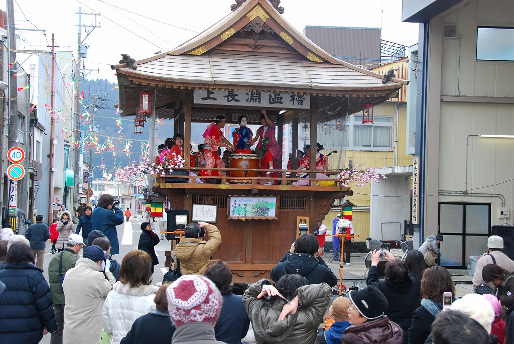
- Kaminaga, 勝山左義長ばやし保存会, CC BY-SA 3.0
- Echizen Shinkin Bank Katsuyama branch, Suikotei, CC BY 4.0
- Yumeore Katsuyama 20240501, Suikotei, CC BY 4.0
- Fukuho Bank Katsuyama Branch & Ono Branch, Suikotei, CC BY 4.0
- Hokuriku Bank Katsuyama Branch, Suikotei, CC BY 4.0
- Katsuyama Tateishi Post office, Suikotei, CC BY 4.0
- Katsuyama City Community Bus at Katsuyama Station, Suikotei, CC BY 4.0
- Katsuyama Station 20240501 01, Suikotei, CC BY 4.0
- TEKI6 at Katsuyama Station 20240501, Suikotei, CC BY 4.0
- Osowacho Hishima, Katsuyama, Fukui Prefecture 911-0831, Japan - panoramio - kiwa dokokano, kiwa dokokano, CC BY-SA 3.0
- Osowacho Hishima, Katsuyama, Fukui Prefecture 911-0831, Japan - panoramio, kiwa dokokano, CC BY-SA 3.0
- Osowacho Hishima, Katsuyama, Fukui Prefecture 911-0831, Japan - panoramio - kiwa dokokano (1), kiwa dokokano, CC BY-SA 3.0
- Osowacho Hishima, Katsuyama, Fukui Prefecture 911-0831, Japan - panoramio - kiwa dokokano (2), kiwa dokokano, CC BY-SA 3.0
- Katsuyama Station 20240501 02, Suikotei, CC BY 4.0
- Echizen Railway MC6111 at Katsuyama Station 20240501, Suikotei, CC BY 4.0
- Echizen Railway MC6102 at Katsuyama Station 20240501, Suikotei, CC BY 4.0
- JA Fukui-ken Katsuyama Minami Community Support Center, Suikotei, CC BY 4.0
- Katsuyama City Sightseeing Bus Dainagon, Suikotei, CC BY 4.0
- Katsuyama city Mimuro elementary school, 藤谷良秀(Fujitani Yoshihide), CC BY-SA 4.0
- Katsuyama Castle, Fukui - 2016-04-26, MathieuMD, CC BY-SA 4.0
- EchizenOnoCastle-01, User:Ajax, CC BY-SA 3.0
- Fukui Prefectural Dinosaur Museum 20231217, Totti, CC BY-SA 4.0
- Katsuyama Castle Museum 2002-06-10, Alpsdake, CC BY-SA 3.0
- Mount Toritate, Alpsdake, CC BY-SA 3.0
- Mt.daibutu, 紫煙, CC BY-SA 3.0
- Mount Dainichi from Mount Hoonji, Alpsdake, CC BY-SA 3.0
- Heisenji Hakusanjinjya HAIDEN, 藤谷良秀(Fujitani Yoshihide), CC BY-SA 4.0
- Hohonjiyama from Kyogatake 2010-11-7, Alpsdake, Public domain
- Mt Johoji, Yasuhiro Kojima, CC BY-SA 4.0
- Shinokura shrine, Opqr, CC BY-SA 4.0
- 15開善寺, Kazuo Ogasawara, CC BY-SA 4.0
- Katsuyama Dinosaur Forest Park, TR15336300101, CC BY-SA 4.0
- Echizen Ono Castle, Keisuke MAEDA, CC BY-SA 4.0
- 福井県立恐竜博物館, GIGA146587, CC BY 4.0
- Shinokurashrinehaidenwinter, Samansa21, CC0
- Toritateyama from Hohojiyama 2005-3-19, Alpsdake, Public domain
- Fukui Benten ryokuchi xl, SHori, CC BY 4.0
- 県道168号線 - panoramio, Yobito KAYANUMA, CC BY-SA 3.0
- Seidai-ji 20240501 02, Suikotei, CC BY 4.0
- Seidai-ji 20240501 01, Suikotei, CC BY 4.0
- COCONO art place 20180429 101134, M'akhr, CC BY-SA 4.0


Page built November 4, 2026. Spotted a mistake? Tell us or suggest a place.