


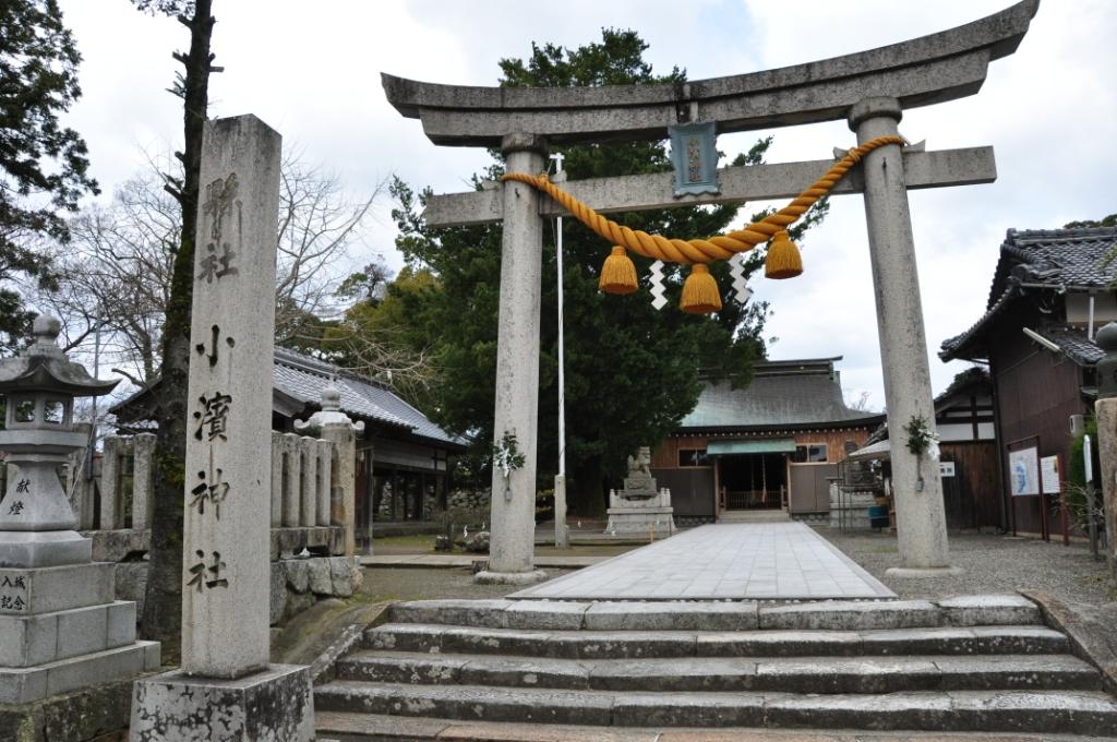


Obama, Japan
小浜市
Obama is a town of 29,435 people in Fukui, Japan, founded in March 30, 1951.
Why visit Obama
Townapedia lists 46 museums and landmarks, 36 parks and trails, 62 places to eat, 14 places to stay and 13 attractions in and around town.
Highlights include Mt. Kusuyagadake, パレア若狭, Okozu Salt Works and 小浜城址.
Weather in Obama
Forecast from MET Norway (CC BY 4.0). Full forecast
About Obama
Obama (小浜市, Obama-shi; Japanese pronunciation: [ò̞.bä́.mä́(.ɕì)]; lit. 'Small Beach') is a city located in Fukui Prefecture, Japan. As of 1 August 2018, the city had an estimated population of 29,435 in 12,057 households and a population density of 240 persons per km2 (327/sq mi). The total area of the city was 233.09 square kilometres (90 sq mi).
From the Wikipedia article Obama, Fukui (this version), under CC BY-SA 4.0.
Travel tips from other travellers: Obama on Wikivoyage (CC BY-SA 4.0).
Things to do13







1 more on the map.
Museums and landmarks46

Okozu Salt Works
Monument and historic site · 8.3 km
Archaeological site





34 more on the map.
Parks, trails and playgrounds36



24 more on the map.
Restaurants and cafes62





50 more on the map.
History
Obama developed as a seaport with connections to the Asian continent even before the start of written history in Japan, and artefacts from China have been found in local tombs from the Kofun period. From the Asuka period and Nara period, salt and seafood from the Obama area were supplied to the imperial dynasty, and under the Ritsuryō system, Obama was the capital of Wakasa Province. Many temples and cultural remains from the Nara and Heian period are found in the Obama area, and the city labels itself "Nara by the sea" in its tourist promotions. As a result of its location in the Wakasa Province area, which travelers passed through when traveling between China and Kyoto, the area was influenced by Chinese culture for a long period. There are many buildings and houses in the Sancho-machi area of the city whose design was influenced by trade with China.
Obama is one of the locations where Japanese citizens were abducted by North Korean agents on 7 July 1978.
The economy of Obama is mixed, with agriculture and commercial fishing playing important roles. Seasonal tourism is of growing importance. Wakasa lacquered chopsticks, agate accessories, and other crafts are made in the area.
From the History section of Obama, Fukui on Wikipedia, under CC BY-SA 4.0.
Where to stay14
Churches and places of worship321
Shopping20
Gas and EV charging9
Schools, colleges and libraries34
Healthcare17
Map of Obama
250 places. The map loads OpenStreetMap tiles when you open it.
Getting there and nearby towns
Osaka Itami Airport (ITM) is the nearest airport with scheduled flights listed in OpenStreetMap, 84 km away.
- Takahama 18 km west, about 18 min by car
- Nagahama 49 km east, about 49 min by car
- Kyoto 53 km south, about 53 min by car
- Hikone 53 km southeast, about 53 min by car
- Ōtsu 56 km south, about 56 min by car
- Kusatsu 57 km south, about 57 min by car
- Takefu 59 km northeast, about 59 min by car
- Sabae 64 km northeast, about 1 h by car
- Sasayama 68 km southwest, about 1 h 15 min by car
- Takatsuki 73 km south, about 1 h 15 min by car
Drive times are estimates from straight-line distance, not routes.
Local news
Headlines from INDB.
Reviews, tips and questions
Loading what members have shared...
Sources and licences
- GeoNames (CC BY 4.0): population, coordinates, regions and time zone
- OpenStreetMap contributors (ODbL 1.0): places, airports, map data
- Wikidata (CC0 1.0): elevation, founding date, time zone, website, landmarks and historic places
- Wikimedia Commons (see each image): photos
- Wikipedia (CC BY-SA 4.0): overview and history text
Photo credits
- Tagarasu-ko myojinhana lighthouse(long), 藤谷良秀, CC BY-SA 3.0
- Okozu Salt making remains, 藤谷良秀, CC BY-SA 4.0
- Obamajinnjya, Lanbea at Japanese Wikipedia, CC BY-SA 3.0
- Myotsuji and pagoda, おはぐろ蜻蛉 at Japanese Wikipedia, Public domain
- Mount Kusuyagadake, TR15336300101, CC BY-SA 4.0
- Tadaji hondou, Opqr, CC BY-SA 4.0
- Tentokuji temple, Opqr, CC BY-SA 4.0
- Obama Culture Hall01b3200, 663highland, CC BY 2.5
- Tomiko Yamakawa Memorial Museum01nt3200, 663highland, CC BY 2.5
- Obama joukouji seimon, Opqr, CC BY-SA 3.0
- Nochise-yama castle ruins Honmaru1, TR15336300101, CC BY-SA 4.0
- Sugita Genpaku Memorial Obama Municipal Hospital01st3200, 663highland, CC BY 2.5
- Kuinji temple, 藤谷良秀, CC BY-SA 4.0
- Haga-Ji Temple 200109, TR15336300101, CC BY-SA 4.0
- Wakasakokubunji, FITM, Public domain
- Jinguji Wakasa Obama Fukui17s3s4410, 663highland, CC BY 2.5
- Wakasa history museum, Opqr, CC BY-SA 4.0
- Obama City Obama second junior high school, 藤谷良秀, CC BY-SA 4.0
- Obama Junior High School, 藤谷良秀, CC BY-SA 4.0
- 福井県立若狭図書学習センター, Opqr, CC BY-SA 4.0
- Myoko-ji, Obama, 運動会プロテインパワー, CC BY-SA 4.0
- 小浜公園の入口, Suomi3, CC BY-SA 4.0
- Myotsuji Obama Fukui Pref03s3s4592, 663highland, CC BY 2.5
- Ao Shima Island In Obama Bay A, さかおり, CC BY-SA 4.0
- 福井県小浜市の文珠地蔵(2021年3月13日), Hidaka-Nyo, CC BY-SA 4.0
- Wakasa high school, 藤谷良秀, CC BY-SA 4.0
- Wakasa Kokubunji, Shakadou, Saigen Jiro, CC0
- Obama Castle (Fukui), honmaru, Saigen Jiro, CC0
- Tentoku-ji Temple in Wakasa town with its gate, ブルーノ・プラス, CC BY 4.0
- Wakasa Nursing School, 運動会プロテインパワー, CC BY-SA 4.0


Page built November 4, 2026. Spotted a mistake? Tell us or suggest a place.