


Keizer, Oregon
Keizer is a city of 39,082 people in Marion County, Oregon, founded in 1982.
Why visit Keizer
Townapedia lists 24 museums and landmarks, 31 parks and trails, 96 places to eat, 5 places to stay and 6 attractions in and around town.
Highlights include Union Street Railroad Bridge, Center Street Bridge, Adolph Block and Boon Brick Store.
August is the warmest month, with average highs of 84°F; December lows average 35°F.
Weather in Keizer
Forecast from the National Weather Service. Full forecast
About Keizer
Keizer () is a city in Marion County, Oregon, United States, along the 45th parallel. As of the 2020 United States census, its population was 39,376, making it the 14th most populous city in Oregon. It lies in the Willamette Valley and is part of the Salem Metropolitan Statistical Area. It was named after pioneer Thomas Dove (T.
From the Wikipedia article Keizer, Oregon (this version), under CC BY-SA 4.0.
Things to do6

Union Street Railroad Bridge
Bridge · National Register of Historic Places · 3.8 mi
Bridge in West Salem, Oregon

Center Street Bridge
Bridge · 4.0 mi
Bridge over the Willamette River in Salem, Oregon, U.S.

L. B. Day Amphitheatre
Cinema and theater · 3.0 mi
Open-air concert venue in Salem, Oregon, United States of America
Marion Street Bridge
Bridge · 3.9 mi
Bridge in United States of America
Peter Courtney Minto Island Bridge
Bridge · 4.4 mi
Bicycle and pedestrian bridge in Salem, Oregon, U.S
Museums and landmarks24

Adolph Block
Monument and historic site · National Register of Historic Places · 4.2 mi
Commercial building in Salem, Oregon

Boon Brick Store
Monument and historic site · National Register of Historic Places · 3.7 mi
Historic building in Salem, Oregon, USA

Bush–Breyman Block
Monument and historic site · National Register of Historic Places · 4.2 mi
Historic building in Salem, Oregon, USA

Capitol Center
Monument and historic site · National Register of Historic Places · 4.3 mi
Commercial building in Salem, Oregon, USA

Carl E. Nelson House
Monument and historic site · National Register of Historic Places · 3.7 mi
Historic house in Oregon, United States
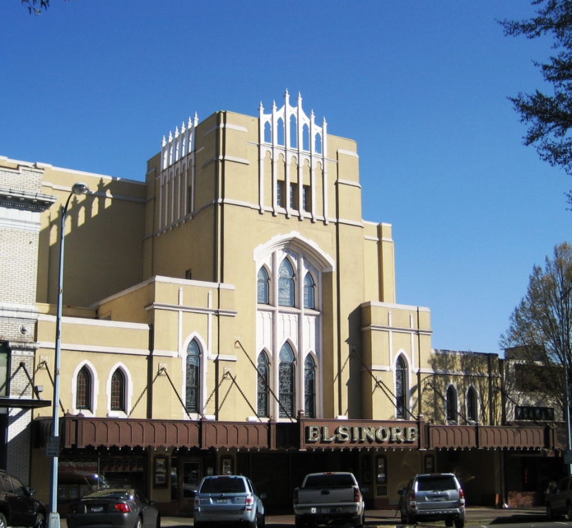
Elsinore Theatre
Monument and historic site · National Register of Historic Places · 4.3 mi
Movie theater in Salem, Oregon, USA

Grand Theatre
Cinema and theater · National Register of Historic Places · 4.2 mi
Former movie theater in Salem, Oregon, United States

Jones–Sherman House
Monument and historic site · National Register of Historic Places · 3.7 mi
Salem, Oregon, listed on the NRHP in Oregon

Lee Mission Cemetery
Monument and historic site · National Register of Historic Places · 4.1 mi
Historic cemetery in Salem, Oregon, USA

Old Garfield School
Monument and historic site · National Register of Historic Places · 4.0 mi
Listed on the NRHP in Marion County, Oregon, United States


Oregon State Capitol
Monument and historic site · National Register of Historic Places · 4.3 mi
State capitol building of the U.S. state of Oregon

Oregon State Fair
Monument and historic site · National Register of Historic Places · 2.9 mi
Annual event in Oregon, United States
12 more on the map.
Parks, trails and playgrounds31


Powerland Heritage Park
Park · 4.1 mi
Campus community of independent museums and event spaces

Roto-Rooter Park
Sports field and stadium · 1.7 mi
6700 Field of Dreams Way Northeast, Keizer


19 more on the map.
Restaurants and cafes96

Applebee's
Diner · American · 2.5 mi
2625 Liberty Street Northeast, Salem
Mo-Fr 11:00-24:00; Sa,Su 00:00-01:00,11:00-24:00



Dutch Bros. Coffee
Cafe · Coffee Shop · 1.8 mi
4612 Portland Road Northeast, Salem
Fr-Sa 05:00-23:00; Tu-Th,Su 05:00-20:00; Mo 09:30-13:30
Dutch Bros. Coffee
Cafe · Coffee Shop · 0.5 mi
4915 River Road North, Keizer
Mo-Th 05:00-22:00; Fr-Sa 05:00-23:00; Su 05:00-22:00
Osaka Hibachi & Sushi
Restaurant · Japanese, Sushi · 1.3 mi
3854 River Road North
Mo-Sa 11:00-21:00; Su 12:00-20:30
Starbucks
Cafe · Coffee Shop · 0.5 mi
4943 River Road North, Keizer
Mo-Fr 05:00-20:00; Sa-Su 05:00-19:30
Starbucks
Cafe · Coffee Shop · 1.1 mi
2555 Jorie Lane Northeast, Keizer
Mo-Fr 04:30-20:30; Sa,Su 05:00-20:30
Sunrise Espresso
Cafe · Coffee Shop · 1.8 mi
4625 Portland Road Northeast, Salem
Mo-Fr 05:00-15:00; Sa 06:00-15:00; Su 07:00-24:00
84 more on the map.
History
The original settlement was at Keizer Bottom, near the banks of the Willamette River. The community was named after Thomas Dove Keizur, one of its first settlers. Somewhere in the translation of donation land claim records, his name was misspelled.
The settlement suffered in the flood of 1861, and the inhabitants rebuilt their homes on higher ground. Further floods in 1943, 1945, 1946 and 1948 hampered the growth of the community, and it was not until dams were built in the 1950s to regulate the flow of the Willamette that Keizer began to flourish.
The city of Salem tried to annex the growing community adjacent to its limits many times. Beginning in 1964, a number of Keizer residents, powered by Janet and Richard Bauer and family, tried to convince the people of Keizer that it would be cheaper and better to form their own city. It was not until November 2, 1982, that, with the support of the nearby unincorporated community of Clear Lake, residents voted to make Keizer a city.
From the History section of Keizer, Oregon on Wikipedia, under CC BY-SA 4.0.
Where to stay5
Holiday Inn Express
Motel and hotel · 1.4 mi
6150 Keizer Station Boulevard Northeast
Churches and places of worship14
Salem First United Methodist Church
Church · National Register of Historic Places · 4.3 mi
Peoples Church
Church · Pentecostal · 2.2 mi
4500 Lancaster Drive Northeast, Salem
Salem Evangelical Church
Church · Evangelical · 2.5 mi
455 Locust Street Northeast
Shopping16
Salem Indoor Flea Market
Shopping center · 1.7 mi
4675 Portland Road Northeast, Salem
Gas and EV charging12
Schools, colleges and libraries48
Chemawa Indian School
School · National Register of Historic Places · 1.7 mi
3700 Chemawa Road Northeast, Salem
Healthcare4
Map of Keizer
250 places. The map loads OpenStreetMap tiles when you open it.
Climate by month
Monthly table
| Month | High | Low | Rain |
|---|---|---|---|
| Jan | 48°F | 36°F | 6.1 in |
| Feb | 52°F | 36°F | 4.5 in |
| Mar | 57°F | 38°F | 4.3 in |
| Apr | 62°F | 41°F | 3.1 in |
| May | 69°F | 46°F | 2.2 in |
| Jun | 75°F | 51°F | 1.2 in |
| Jul | 84°F | 55°F | 0.2 in |
| Aug | 84°F | 55°F | 0.4 in |
| Sep | 78°F | 51°F | 1.5 in |
| Oct | 65°F | 44°F | 3.5 in |
| Nov | 54°F | 39°F | 6.0 in |
| Dec | 47°F | 35°F | 7.0 in |
U.S. Climate Normals 1991-2020 for Salem Mcnary Fld 72694 (7 mi away), NOAA NCEI.
People and cost of living
American Community Survey 5-year estimates, 2020-2024, U.S. Census Bureau. Estimates have margins of error, larger for small towns.
Disaster history
Marion County has had 11 federal disaster declarations since 2000, most often for fires.
- 2023-08-24: Liberty Fire (Fire)
- 2021-05-04: Severe Winter Storm (Severe Storm)
- 2020-09-15: Wildfires And Straight-Line Winds (Fire)
- 2020-09-10: Wildfires (Fire)
- 2020-09-08: Beachie Creek Lionshead Fire Complex (Fire)
- 2020-03-28: Covid-19 Pandemic (Biological)
OpenFEMA disaster declarations summaries.
Getting there and nearby towns
Salem - Willamette Valley Airport (SLE) is the nearest airport with scheduled flights listed in OpenStreetMap, 6 miles away.
- Hayesville 3 mi southeast, about 4 min by car
- Salem 5 mi south, about 9 min by car
- Four Corners 5 mi southeast, about 9 min by car
- Independence 13 mi southwest, about 21 min by car
- Dallas 15 mi west, about 25 min by car
- Canby 24 mi northeast, about 39 min by car
- Albany 26 mi south, about 42 min by car
- Corvallis 32 mi southwest, about 52 min by car
- Beaverton 34 mi north, about 55 min by car
- Aloha 35 mi north, about 56 min by car
Drive times are estimates from straight-line distance, not routes.
Local news
Headlines from INDB, the NEMICO news database.
Reviews, tips and questions
Loading what members have shared...
Sources and licences
- NCES EDGE (Public domain): public schools
- NOAA NCEI U.S. Climate Normals 1991-2020 (Public domain): climate by month
- OpenFEMA (Public domain): disaster declarations
- OpenStreetMap contributors (ODbL 1.0): places, airports, map data
- U.S. Census Bureau (Public domain): population, income, housing, education, commute
- Wikidata (CC0 1.0): elevation, founding date, time zone, website, landmarks and historic places
- Wikimedia Commons (see each image): photos
- Wikipedia (CC BY-SA 4.0): overview and history text
Photo credits
- Keizer Station in Oregon 2, M.O. Stevens, CC BY 3.0
- Keizer City Hall, Keizer - DPLA - 6ce1d2139f26d01e987f8c01eed612ee, Gary Halvorson, Oregon State Archives, CC BY 4.0
- Keizer City Center (49588395196), Oregon Department of Transportation, CC BY 2.0
- File-5495 Chugath Street - entry porch detail - Chemawa Indian School - Salem Oregon, Historic American Buildings Survey, Public domain
- United Methodist Salem Oregon corner, M.O. Stevens, Public domain
- Reed Opera House Mall - Salem Oregon, Andrew Parodi at English Wikipedia, CC BY-SA 3.0
- Old Garfield School front - Salem, Oregon, M.O. Stevens, CC BY-SA 3.0
- Waller Hall Willamette University - Salem Oregon, M.O. Stevens at en.wikipedia, Public domain
- ODCDomeBuilding1, Katr67, Public domain
- Elsinore Theatre Salem Oregon, M.O. Stevens, Public domain
- LeeGate, Katr67, Public domain
- Union Street Railroad Bridge, Cjdaniel, CC BY-SA 3.0
- Oregon State Capitol 1, M.O. Stevens, Public domain
- Jones-Sherman House side - Salem, Oregon, M.O. Stevens, CC BY-SA 3.0
- Boone's Treasury side, M.O. Stevens, Public domain
- Chemeketa Lodge - Odd Fellows Buildings Salem Oregon, M.O. Stevens, Public domain
- Old First National Bank Building Salem Oregon, M.O. Stevens, Public domain
- Salem Oregon downtown State Street buildings, M.O. Stevens, Public domain
- Carl E. Nelson House front east - Salem, Oregon, M.O. Stevens, CC BY-SA 3.0
- Bush-Breyman Block (Breyman Portion) Salem Oregon full, M.O. Stevens, CC BY-SA 4.0
- OregonSupremeCourtBldg, User:Cacophony, CC BY-SA 2.5
- Adolph Block - Salem, Oregon, M.O. Stevens, CC BY-SA 3.0
- Western Oregon University booth (49587904383), Oregon Department of Transportation, CC BY 2.0
- GeoEngineers (49588643262), Oregon Department of Transportation, CC BY 2.0
- McKay High School InvenTeam (49588643362), Oregon Department of Transportation, CC BY 2.0
- Steering Committee members (49587903823), Oregon Department of Transportation, CC BY 2.0
- George Fox booth (49588397016), Oregon Department of Transportation, CC BY 2.0
- Core sampling activity (49587903948), Oregon Department of Transportation, CC BY 2.0
- Ecological Engineering (49588642817), Oregon Department of Transportation, CC BY 2.0
- Oregon DOT's Cesar Lopez discusses civil engineering (49587902953), Oregon Department of Transportation, CC BY 2.0
- Steve Goss, Hemex Health, talks electrical engineering (49588396886), Oregon Department of Transportation, CC BY 2.0
- Materials (49587905043), Oregon Department of Transportation, CC BY 2.0
- McKay High School InvenTeam members (49588398251), Oregon Department of Transportation, CC BY 2.0
- Kira Glover from Cutter Chemical (49587902698), Oregon Department of Transportation, CC BY 2.0
- Adaptive Cup display (49588642927), Oregon Department of Transportation, CC BY 2.0
- ODOT Geomatics (49588398616), Oregon Department of Transportation, CC BY 2.0
- ODOT's Kira Glover-Cutter and Chris Glantz discuss chemical engineering (49587904073), Oregon Department of Transportation, CC BY 2.0
- Oregon Institute of Technology booth (49587904273), Oregon Department of Transportation, CC BY 2.0
- MECOP booth (49588641832), Oregon Department of Transportation, CC BY 2.0
- University of Portland (49587904838), Oregon Department of Transportation, CC BY 2.0


Page built October 30, 2026. Spotted a mistake? Tell us or suggest a place.