


Laurens, South Carolina
Laurens is a city of 9,336 people in Laurens County, South Carolina, founded in 1785.
Why visit Laurens
Townapedia lists 19 museums and landmarks, 9 parks and trails, 32 places to eat, 2 places to stay and 2 attractions in and around town.
Highlights include Capitol Theatre, Laurens County Courthouse and Laurens Historic District.
July is the warmest month, with average highs of 91°F; January lows average 30°F.
Weather in Laurens
Forecast from the National Weather Service. Full forecast
About Laurens
Laurens is a city in Laurens County, South Carolina, United States. As of the 2020 census, Laurens had a population of 9,335. It is the county seat of Laurens County. It is part of the Greenville-Mauldin-Easley metropolitan area.
From the Wikipedia article Laurens, South Carolina (this version), under CC BY-SA 4.0.
Things to do2

Museums and landmarks19

Laurens County Courthouse
Monument and historic site · National Register of Historic Places · 0.5 mi
Historic county courthouse in Laurens, South Carolina

Laurens Historic District
Monument and historic site · National Register of Historic Places · 0.4 mi
Historic district in South Carolina, United States

South Harper Historic District
Monument and historic site · National Register of Historic Places · 0.8 mi
Historic district in South Carolina, United States

Albright-Dukes House
Monument and historic site · National Register of Historic Places · 0.9 mi
United States historic place

Charles H. Duckett House
Monument and historic site · National Register of Historic Places · 0.6 mi
Historic house in South Carolina, United States

Dr. William Claudius Irby House
Monument and historic site · National Register of Historic Places · 0.6 mi
Historic house in South Carolina, United States

Irby-Henderson-Todd House
Monument and historic site · National Register of Historic Places · 1.0 mi
Historic house in South Carolina, United States

James Dunklin House
Monument and historic site · National Register of Historic Places · 0.4 mi
Historic house in South Carolina, United States
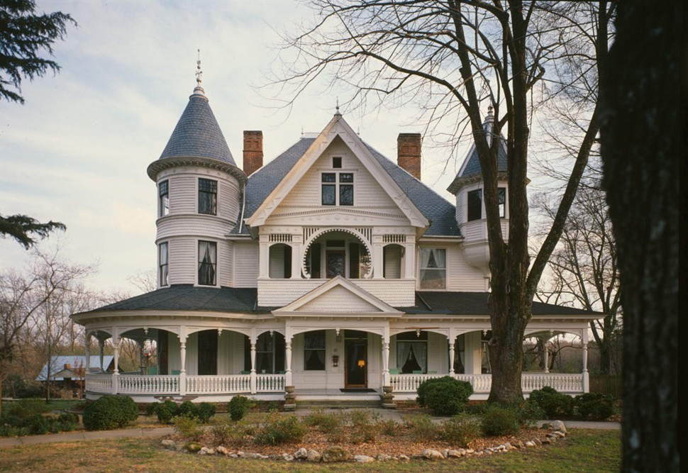
John Calvin Owings House
Monument and historic site · National Register of Historic Places · 0.7 mi
Historic house in South Carolina, United States

Lyde Irby Darlington House
Monument and historic site · National Register of Historic Places · 0.6 mi
Historic house in South Carolina, United States

Octagon House
Monument and historic site · National Register of Historic Places · 1.2 mi
Historic house in South Carolina, United States


Sitgreaves House
Monument and historic site · National Register of Historic Places · 1.0 mi
Historic house in South Carolina, United States
7 more on the map.
Parks, trails and playgrounds9



Restaurants and cafes32


Garcia's Kitchen
Restaurant · Mexican · 1.5 mi
1500 Western Square Drive, Laurens
20 more on the map.
History
Located in upstate South Carolina, the city of Laurens is named after Henry Laurens, a South Carolina merchant and rice planter who was one of America's wealthiest slave traders. He was a delegate to and second president of the Continental Congress and served as a diplomat.
Laurens was established by an act of the General Assembly on March 15, 1785, as a location for commercial activities. It was one of the six counties created from the Old Ninety-Six District of South Carolina. Laurens was originally named Laurensville. On December 15, 1845, a charter was issued with the name of Laurensville. The first appearance of the town name Laurens was in an 1873 charter. The town of Laurens was chartered in 1900 and in 1916. It was named in honor of South Carolina statesman Henry Laurens.
The first inhabitants of Laurens were the Cherokee Indians. They used the land as their hunting and fighting ground. There has been evidence of broken potsherds, weapons, and a mound found linked to Cherokee culture on land now called Laurens. Many treaties were made with the Cherokee over the land known as Laurens County dating to 1721. Before the American Revolution, thousands of immigrants, mainly from Scotland and Ireland, settled in Laurens County. Later Laurens developed into a major intersection of commerce in colonial America. In the Battle of Musgrove Mill, Laurens witnessed intense fighting.
From the History section of Laurens, South Carolina on Wikipedia, under CC BY-SA 4.0.
Where to stay2
Churches and places of worship28
Central United Methodist Church
Church · United Methodist · 1.1 mi
100 Wilson Street, Laurens
Shopping12
Perfectly Imperfect Vintage & Decor
Shop · 0.5 mi
100 South Public Square, Laurens
Gas and EV charging8
Schools, colleges and libraries15
Healthcare5
Map of Laurens
132 places. The map loads OpenStreetMap tiles when you open it.
Climate by month
Monthly table
| Month | High | Low | Rain | Snow |
|---|---|---|---|---|
| Jan | 53°F | 30°F | 4.2 in | 0.5 in |
| Feb | 57°F | 33°F | 4.0 in | 0.4 in |
| Mar | 65°F | 39°F | 4.7 in | 0.2 in |
| Apr | 74°F | 47°F | 3.6 in | 0.0 in |
| May | 81°F | 58°F | 3.4 in | 0.0 in |
| Jun | 88°F | 66°F | 4.2 in | 0.0 in |
| Jul | 91°F | 70°F | 3.6 in | 0.0 in |
| Aug | 89°F | 68°F | 4.1 in | 0.0 in |
| Sep | 84°F | 62°F | 3.6 in | 0.0 in |
| Oct | 74°F | 49°F | 3.3 in | 0.0 in |
| Nov | 64°F | 38°F | 3.6 in | 0.0 in |
| Dec | 56°F | 33°F | 4.5 in | 0.2 in |
U.S. Climate Normals 1991-2020 for Laurens Hcn (0 mi away), NOAA NCEI.
People and cost of living
American Community Survey 5-year estimates, 2020-2024, U.S. Census Bureau. Estimates have margins of error, larger for small towns.
Disaster history
Laurens County has had 21 federal disaster declarations since 2000, most often for hurricanes.
- 2026-01-23: Severe Winter Storm (Winter Storm)
- 2024-09-29: Hurricane Helene (Hurricane)
- 2024-09-26: Hurricane Helene (Tropical Storm)
- 2024-08-05: Hurricane Debby (Tropical Storm)
- 2023-08-31: Hurricane Idalia (Hurricane)
- 2022-11-21: Hurricane Ian (Hurricane)
OpenFEMA disaster declarations summaries.
Getting there and nearby towns
Greenwood County Airport (GRD) is the nearest airport with scheduled flights listed in OpenStreetMap, 19 miles away.
- Clinton 9 mi east, about 15 min by car
- Joanna 14 mi southeast, about 22 min by car
- Fountain Inn 17 mi northwest, about 27 min by car
- Simpsonville 21 mi northwest, about 33 min by car
- Honea Path 22 mi west, about 35 min by car
- Greenwood 23 mi south, about 36 min by car
- Five Forks 24 mi northwest, about 39 min by car
- Due West 24 mi southwest, about 39 min by car
- Mauldin 25 mi northwest, about 40 min by car
- Greenville 30 mi northwest, about 49 min by car
Drive times are estimates from straight-line distance, not routes.
Local news
Headlines from INDB, the NEMICO news database.
Reviews, tips and questions
Loading what members have shared...
Sources and licences
- NCES EDGE (Public domain): public schools
- NOAA NCEI U.S. Climate Normals 1991-2020 (Public domain): climate by month
- OpenFEMA (Public domain): disaster declarations
- OpenStreetMap contributors (ODbL 1.0): places, airports, map data
- U.S. Census Bureau (Public domain): population, income, housing, education, commute
- Wikidata (CC0 1.0): elevation, founding date, time zone, website, landmarks and historic places
- Wikimedia Commons (see each image): photos
- Wikipedia (CC BY-SA 4.0): overview and history text
Photo credits
- South Carolina - Laurens, Unknown author Unknown author or not provided, Public domain
- Laurens Historic District, Bill Fitzpatrick, CC BY-SA 3.0
- South Harper Historic District, Bill Fitzpatrick, CC BY-SA 3.0
- Laurens - Court House, Palmetto Drug Co., Laurens (publisher), Public domain
- Irby Henderson Todd House, Bigskybill, CC BY-SA 3.0
- James Dunklin House, Bill Fitzpatrick, CC BY-SA 3.0
- Wilson Clary House, Bill Fitzpatrick, CC BY-SA 3.0
- Sitgreaves House, Bill Fitzpatrick, CC BY-SA 3.0
- William Dunlap Simpson House, Bill Fitzpatrick, CC BY-SA 3.0
- Charles Duckett House, Bill Fitzpatrick, CC BY-SA 3.0
- Williams-Ball-Copeland House, Bill Fitzpatrick, CC BY-SA 3.0
- Dr. William Claudius Irby, Bill Fitzpatrick, CC BY-SA 3.0
- Lyde Irby Darlington House, Bill Fitzpatrick, CC BY-SA 3.0
- Albright Dukes House, Bill Fitzpatrick, CC BY-SA 3.0
- John-owings-house-sc1, Jack Boucher (photographer), Public domain


Page built October 30, 2026. Spotted a mistake? Tell us or suggest a place.