


Leonardo, New Jersey
Leonardo is a community of 2,493 people in Monmouth County, New Jersey.
Why visit Leonardo
Townapedia lists 6 museums and landmarks, 6 parks and trails, 14 places to eat, 2 places to stay and 5 attractions in and around town.
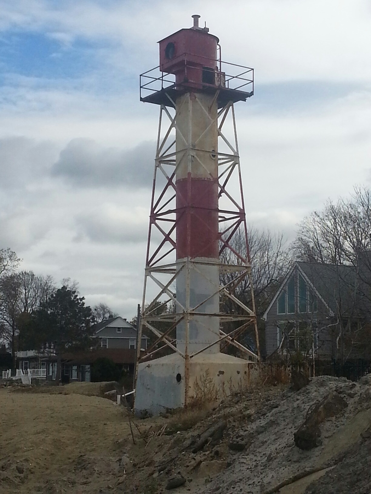
Highlights include Chapel Hill Rear Range Light, Conover Beacon, Dempsey Pump House and MacLeod-Rice House.
July is the warmest month, with average highs of 84°F; January lows average 25°F.
Weather in Leonardo
Forecast from the National Weather Service. Full forecast
About Leonardo
Leonardo is an unincorporated community and census-designated place (CDP) located on the north shore of Middletown Township, in Monmouth County, New Jersey, United States. The community is situated along the Raritan Bayshore and is part of the Jersey Shore region of the state. As of the 2020 United States census, the CDP's population was 2,549, a decrease of 208 (-7.5%) from the 2,757 enumerated at the 2010 census, which in turn had reflected a decline of 66 (-2.3%) from the 2,823 counted at the 2000 census. The ZIP Code for Leonardo is 07737.
From the Wikipedia article Leonardo, New Jersey (this version), under CC BY-SA 4.0.
Things to do5

Chapel Hill Rear Range Light
Lighthouse · 1.5 mi
Lighthouse in New Jersey, United States


Museums and landmarks6

Dempsey Pump House
Monument and historic site · National Register of Historic Places
Historic building in Monmouth County, New Jersey

MacLeod-Rice House
Monument and historic site · National Register of Historic Places · 0.7 mi
Historic house in Monmouth County, New Jersey

Seabrook-Wilson House
Monument and historic site · National Register of Historic Places · 2.2 mi
Historic house in New Jersey, United States


PS Alexander Hamilton
Monument and historic site · National Register of Historic Places · 1.3 mi

Atlantic Highlands Historica
Museum · 1.5 mi
27 Prospect Circle, Atlantic Highlands
Parks, trails and playgrounds6



Restaurants and cafes14

Christine's
Restaurant · Italian · 1.3 mi
42 1st Avenue, Atlantic Highlands
Mo Closed; Tu-Sa 17:00-21:00; Su 16:00-21:00

Hudsen Cafe
Cafe · 1.2 mi
25 1st Avenue, Atlantic Highlands
Mo closed; Tu-Fr 08:00-14:00; Sa-Su 08:00-13:00
Pomodoro Rosso Italian Grill & Pizzeria
Restaurant · Pizza, Italian · 1.3 mi
5 bayshore Plaza, Atlantic Highlands


McDonald's
Fast food · Burger · 0.9 mi
970 Route 36, Alantic Highlands
Mo-Th 07:00-22:00; Fr-Sa 07:00-23:00; Su 07:00-22:00
2 more on the map.
History
Leonardo is named for Henry and James Leonard, the first ironmasters of New Jersey.
During World War II, the large dock complex of Naval Weapons Station Earle was built to supply ammunition to the forces.
Leonardo is known as the site of the only casualties of the US Nike Missile program. On May 22, 1958, an Ajax missile exploded at the Nike missile base in Leonardo, killing six soldiers and four civilians. Since the Project Nike shutdown in 1974, the Leonardo launch base, designated NY-53, has been redeveloped into single-family home sites.
From the History section of Leonardo, New Jersey on Wikipedia, under CC BY-SA 4.0.
Where to stay2
Churches and places of worship6
All Saint's Memorial Church
Church · National Register of Historic Places · 2.5 mi
Shopping1
Super Foodtown of Atlantic Highlands
Grocery · 1.2 mi
3 Bayshore Plaza, Atlantic Highlands
Gas and EV charging3
Schools, colleges and libraries41
Healthcare1
Bayshore Pharmacy
Clinic and pharmacy · 1.2 mi
2 Bayshore Plaza, Atlantic Highlands
Map of Leonardo
85 places. The map loads OpenStreetMap tiles when you open it.
Climate by month
Monthly table
| Month | High | Low | Rain |
|---|---|---|---|
| Jan | 42°F | 25°F | 4.2 in |
| Feb | 43°F | 26°F | 3.3 in |
| Mar | 49°F | 32°F | 4.3 in |
| Apr | 59°F | 41°F | 3.9 in |
| May | 68°F | 51°F | 4.1 in |
| Jun | 78°F | 61°F | 4.3 in |
| Jul | 84°F | 67°F | 4.4 in |
| Aug | 82°F | 65°F | 6.3 in |
| Sep | 76°F | 59°F | 4.3 in |
| Oct | 66°F | 47°F | 4.7 in |
| Nov | 56°F | 37°F | 3.8 in |
| Dec | 47°F | 30°F | 4.8 in |
U.S. Climate Normals 1991-2020 for Long Branch-Oakhurst Hcn (9 mi away), NOAA NCEI.
People and cost of living
American Community Survey 5-year estimates, 2020-2024, U.S. Census Bureau. Estimates have margins of error, larger for small towns.
Disaster history
Monmouth County has had 16 federal disaster declarations since 2000, most often for hurricanes.
- 2021-09-05: Remnants Of Hurricane Ida (Hurricane)
- 2021-09-02: Remnants Of Hurricane Ida (Hurricane)
- 2020-12-11: Tropical Storm Isaias (Hurricane)
- 2020-03-25: Covid-19 Pandemic (Biological)
- 2020-03-13: Covid-19 (Biological)
- 2016-03-14: Severe Winter Storm And Snowstorm (Severe Storm)
OpenFEMA disaster declarations summaries.
Getting there and nearby towns
Linden Airport (LDJ) is the nearest airport with scheduled flights listed in OpenStreetMap, 17 miles away.
- Belford 1 mi northwest, about 2 min by car
- Atlantic Highlands 2 mi east, about 3 min by car
- Highlands 4 mi east, about 6 min by car
- Fairview 4 mi south, about 6 min by car
- Fair Haven 4 mi south, about 7 min by car
- Red Bank 5 mi south, about 8 min by car
- Keansburg 5 mi northwest, about 9 min by car
- Keyport 7 mi west, about 12 min by car
- Eatontown 9 mi south, about 14 min by car
- Long Branch 9 mi southeast, about 15 min by car
Drive times are estimates from straight-line distance, not routes.
Local news
Headlines from INDB, the NEMICO news database.
Reviews, tips and questions
Loading what members have shared...
Sources and licences
- NCES EDGE (Public domain): public schools
- NOAA NCEI U.S. Climate Normals 1991-2020 (Public domain): climate by month
- OpenFEMA (Public domain): disaster declarations
- OpenStreetMap contributors (ODbL 1.0): places, airports, map data
- U.S. Census Bureau (Public domain): population, income, housing, education, commute
- Wikidata (CC0 1.0): elevation, founding date, time zone, website, landmarks and historic places
- Wikimedia Commons (see each image): photos
- Wikipedia (CC BY-SA 4.0): overview and history text
Photo credits
- Dempsey Pump House stonework, Leonardo, NJ, Zeete, CC BY-SA 4.0
- Dempsey Pump House, Leonardo, NJ, Zeete, CC BY-SA 4.0
- Leonardo, NJ State Marina, Oct. 2026, Mr. Matté (if there is an issue with this image, contact me using this image's Commons talk page , my Commons user talk page , or my English Wikipedia user talk page ; I'll know about it a lot faster), CC BY-SA 4.0
- Florence Avenue eb, Leonardo, NJ, Oct. 2026, Mr. Matté (if there is an issue with this image, contact me using this image's Commons talk page , my Commons user talk page , or my English Wikipedia user talk page ; I'll know about it a lot faster), CC BY-SA 4.0
- Beautiful facade of All Saints, Navesink, Bestbudbrian, CC BY-SA 4.0
- MACLEOD- RICE HOUSE, MIDDLETOWN, MONMOUTH COUNTY, NJ, JERRYE & ROY KLOTZ, M.D., CC BY-SA 4.0
- Seabrook-Wilson House, akaBuddy, CC BY-SA 3.0
- PS Alexander Hamilton on Hudson 1966, Operabones, CC BY-SA 3.0
- Conover Beacon November 2013, DavidinNJ, CC BY-SA 3.0
- Center Avenue eb entering Atlantic Highlands, NJ, Oct. 2026, Mr. Matté (if there is an issue with this image, contact me using this image's Commons talk page , my Commons user talk page , or my English Wikipedia user talk page ; I'll know about it a lot faster), CC BY-SA 4.0
- 2018-05-25 14 37 53 View north along New Jersey State Route 36 (Memorial Parkway) just north of Monmouth County Route 516 (Leonardville Road) in Middletown Township, Monmouth County, New Jersey, Famartin, CC BY-SA 4.0
- 2018-05-28 17 44 00 View west along Monmouth County Route 516 (Leonardville Road) at New Jersey State Route 36 in Middletown Township, Monmouth County, New Jersey, Famartin, CC BY-SA 4.0
- 2020-09-10 11 59 25 View north along New Jersey State Route 36 at the exit for Monmouth County Route 516 WEST (Leonardville Road, Highlands) in Middletown Township, Monmouth County, New Jersey, Famartin, CC BY-SA 4.0
- 2020-09-10 11 57 52 View north along New Jersey State Route 36 just south of the exit for Monmouth County Route 516 WEST (Leonardville Road, Highlands) in Atlantic Highlands, Monmouth County, New..., Famartin, CC BY-SA 4.0
- Anomia simplex 541957769, gwtstl, CC BY 4.0
- Atlantic Highlands, NJ post office, Sept. 2026, Mr. Matté (if there is an issue with this image, contact me using this image's Commons talk page , my Commons user talk page , or my English Wikipedia user talk page ; I'll know about it a lot faster), CC BY-SA 4.0
- First Avenue sb, Atlantic Highlands, NJ, Dougtone, CC BY-SA 2.0
- Atlantic Highlands, NJ Municipal Building, Sept. 2026, Mr. Matté (if there is an issue with this image, contact me using this image's Commons talk page , my Commons user talk page , or my English Wikipedia user talk page ; I'll know about it a lot faster), CC BY-SA 4.0
- Veterans Park, Atlantic Highlands, NJ, Sept. 2026, Mr. Matté (if there is an issue with this image, contact me using this image's Commons talk page , my Commons user talk page , or my English Wikipedia user talk page ; I'll know about it a lot faster), CC BY-SA 4.0
- Monmouth CR 8 eb from First Avenue, Atlantic Highlands, NJ, Sept. 2026, Mr. Matté (if there is an issue with this image, contact me using this image's Commons talk page , my Commons user talk page , or my English Wikipedia user talk page ; I'll know about it a lot faster), CC BY-SA 4.0
- First Avenue nb, Atlantic Highlands, NJ (2), Dougtone, CC BY-SA 2.0
- Atlantic Highlands, NJ Elementary School, Sept. 2026, Mr. Matté (if there is an issue with this image, contact me using this image's Commons talk page , my Commons user talk page , or my English Wikipedia user talk page ; I'll know about it a lot faster), CC BY-SA 4.0
- First Avenue nb, Atlantic Highlands, NJ (1), Dougtone, CC BY-SA 2.0
- Monmouth CR 8 wb, Atlantic Highlands, NJ (5), Sept. 2026, Mr. Matté (if there is an issue with this image, contact me using this image's Commons talk page , my Commons user talk page , or my English Wikipedia user talk page ; I'll know about it a lot faster), CC BY-SA 4.0
- Argonaut Jr. Submarine Replica, Nemravik, CC BY-SA 4.0
- Argonaut Jr. Submarine Replica Plaque, Nemravik, CC BY-SA 4.0
- SeatreakWallstreetFerryAccident (8970852506), NTSBgov, Public domain
- Sandy Hook 1, Chester Cory Roberts Ii, CC BY 3.0
- Sandy Hook 3, Chester Cory Roberts Ii, CC BY 3.0
- Sandy Hook 2, Chester Cory Roberts Ii, CC BY 3.0
- New York Skyline (5563468196), InSapphoWeTrust from Los Angeles, California, USA, CC BY-SA 2.0
- East Avenue nb, Belford, NJ, Aug. 2025, Mr. Matté (if there is an issue with this image, contact me using this image's Commons talk page , my Commons user talk page , or my English Wikipedia user talk page ; I'll know about it a lot faster), CC BY-SA 4.0
- 930 Belford Harbour, NJ, LittleGun, CC BY-SA 3.0
- 931 Belford Harbour, NJ, LittleGun, CC BY-SA 3.0
- Bayshore Waterfront Park, Belford, NJ, Aug. 2025, Mr. Matté (if there is an issue with this image, contact me using this image's Commons talk page , my Commons user talk page , or my English Wikipedia user talk page ; I'll know about it a lot faster), CC BY-SA 4.0
- 2018-05-25 14 33 31 View north along New Jersey State Route 36 (Memorial Parkway) between 7th Avenue and 3rd Avenue in Atlantic Highlands, Monmouth County, New Jersey, Famartin, CC BY-SA 4.0
- 2018-05-25 15 45 08 View south along New Jersey State Route 36 (Memorial Parkway) between 3rd Avenue and 7th Avenue in Atlantic Highlands, Monmouth County, New Jersey, Famartin, CC BY-SA 4.0


Page built October 30, 2026. Spotted a mistake? Tell us or suggest a place.