


Atlantic Highlands, New Jersey
Atlantic Highlands is a borough of 4,410 people in Monmouth County, New Jersey, founded in February 28, 1887.
Why visit Atlantic Highlands
Townapedia lists 14 museums and landmarks, 8 parks and trails, 14 places to eat and 5 attractions in and around town.
Highlights include Chapel Hill Rear Range Light, Conover Beacon, Dempsey Pump House and Fort Hancock and the Sandy Hook Proving Ground Historic District.
July is the warmest month, with average highs of 84°F; January lows average 25°F.
Weather in Atlantic Highlands
Forecast from the National Weather Service. Full forecast
About Atlantic Highlands
Atlantic Highlands is a borough in Monmouth County in the U.S. state of New Jersey, in the Bayshore Region. As of the 2020 United States census, the borough's population was 4,414, an increase of 29 (+0.7%) from the 2010 census count of 4,385, which in turn reflected a decline of 320 (−6.8%) from the 4,705 in the 2000 census.
From the Wikipedia article Atlantic Highlands, New Jersey (this version), under CC BY-SA 4.0.
Things to do5

Chapel Hill Rear Range Light
Lighthouse · 2.1 mi
Lighthouse in New Jersey, United States
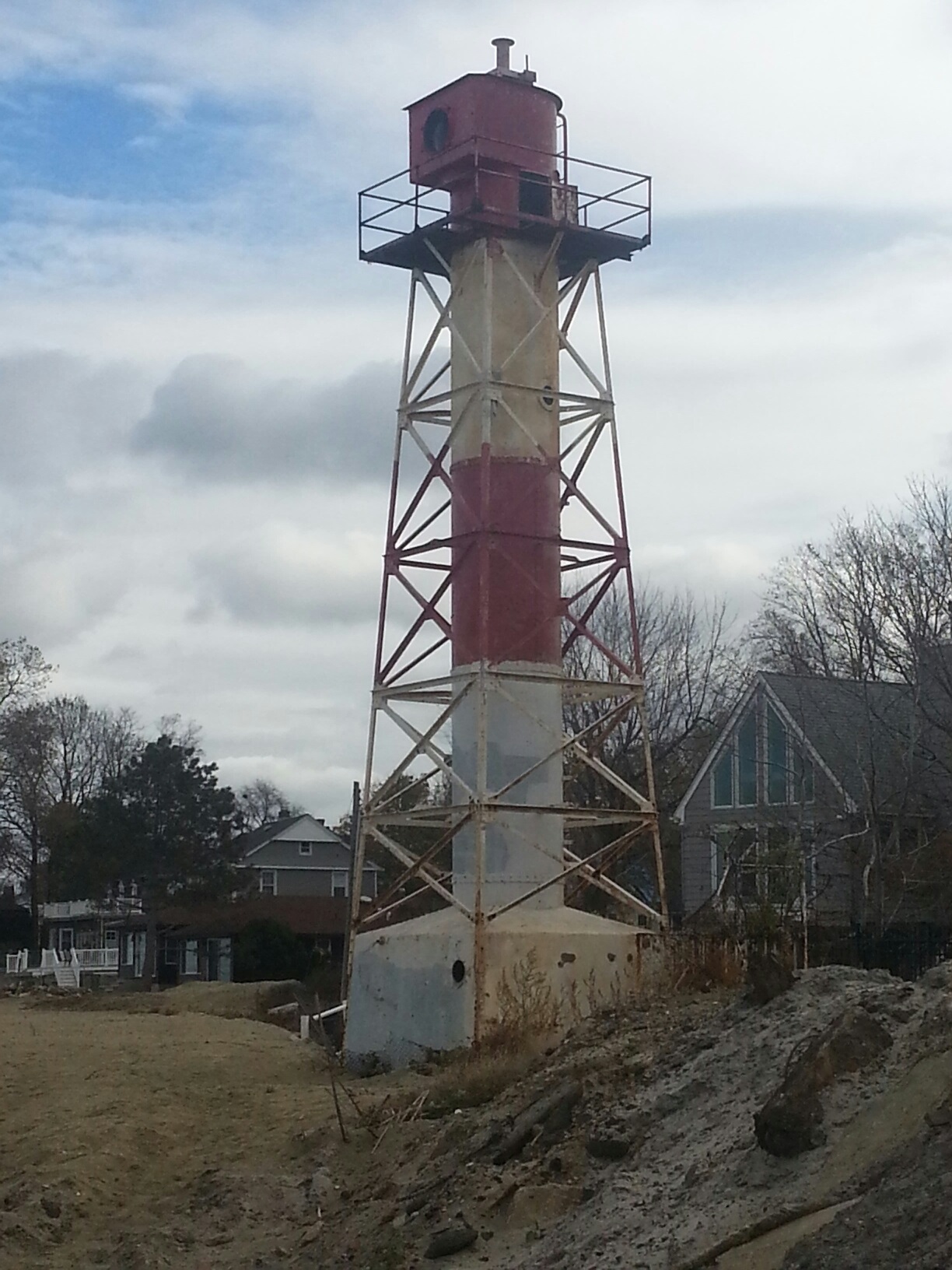
Conover Beacon
Lighthouse · 1.8 mi
Lighthouse in New Jersey, United States

Highlands–Sea Bright Bridge
Bridge · 2.6 mi
Bridge in United States of America

Museums and landmarks14

Dempsey Pump House
Monument and historic site · National Register of Historic Places · 1.9 mi
Historic building in Monmouth County, New Jersey

Fort Hancock and the Sandy Hook Proving Ground Historic District
Monument and historic site · National Register of Historic Places · 2.9 mi
Historic district and landmark in Monmouth County, New Jersey

Fort Hancock, U.S. Life Saving Station
Monument and historic site · National Register of Historic Places · 2.2 mi
Building in New Jersey, United States

Highlands Air Force Station
Monument and historic site · National Register of Historic Places · 2.2 mi
Former military installation in Middletown Township, New Jersey

MacLeod-Rice House
Monument and historic site · National Register of Historic Places · 1.7 mi
Historic house in Monmouth County, New Jersey

Navesink Twin Lights
Monument and historic site · National Register of Historic Places · 2.3 mi
Lighthouse in New Jersey, United States

Water Witch Club Casino
Monument and historic site · National Register of Historic Places · 1.8 mi
Building in New Jersey, United States

Water Witch Club Historic District
Monument and historic site · National Register of Historic Places · 1.7 mi
Historic district in New Jersey, United States

PS Alexander Hamilton
Monument and historic site · National Register of Historic Places · 0.8 mi

Halyburton Memorial
Monument and historic site · 2.8 mi
Memorial to Hamilton Douglas Halyburton at Sandy Hook, New Jersey


Atlantic Highlands Historica
Museum · 0.5 mi
27 Prospect Circle, Atlantic Highlands
2 more on the map.
Parks, trails and playgrounds8

Mount Mitchell Scenic Overlook County Park
Park · 1.1 mi
460 Ocean Boulevard, Atlantic Highlands
Mo-Su 07:00-20:00


Gateway National Recreation Area
Park · 3.1 mi
Parks and beaches in New York City and New Jersey


Restaurants and cafes14

Christine's
Restaurant · Italian · 0.7 mi
42 1st Avenue, Atlantic Highlands
Mo Closed; Tu-Sa 17:00-21:00; Su 16:00-21:00

Hudsen Cafe
Cafe · 0.7 mi
25 1st Avenue, Atlantic Highlands
Mo closed; Tu-Fr 08:00-14:00; Sa-Su 08:00-13:00
Chiafullo's
Restaurant · Italian · 0.8 mi
1010 NJ-36, Atlantic Highlands
Pomodoro Rosso Italian Grill & Pizzeria
Restaurant · Pizza, Italian · 1.0 mi
5 bayshore Plaza, Atlantic Highlands


McDonald's
Fast food · Burger · 1.2 mi
970 Route 36, Alantic Highlands
Mo-Th 07:00-22:00; Fr-Sa 07:00-23:00; Su 07:00-22:00
2 more on the map.
History
The town overlooks where the Atlantic Ocean and Raritan Bay meet at Sandy Hook, and its hills mark the highest point on the eastern seaboard of the U.S. south of Maine.
For hundreds of years, the original inhabitants were the Lenape, who lived in and along the cliffs and creeks of Atlantic Highlands. The Lenape traded with the Europeans and sold a group of English settlers an area that covered the entire peninsula that was named Portland Poynt. The area was laid out with 10 lots in 1667, making them the first European residents of present-day Atlantic Highlands.
Colonists convened the first Assembly of New Jersey in 1667 in what is now Atlantic Highlands. During Revolutionary War years, loyalists to the British crown and patriots of the new America clashed in repeated raids and counterattacks across these lands. Retreating English troops passed through after their defeat in 1778 by George Washington at the Battle of Monmouth.
During the late 1800s, the many farms were subdivided by resort developers, church groups and builders who created the Victorian core of the borough, attracting thousands of visitors and year-round residents.
In 1879, a surveyor was engaged to lay roads and lots for a permanent community. The Atlantic Highlands Association was formed by prominent members of the Methodist Church. This organization developed the community of Atlantic Highlands.
From the History section of Atlantic Highlands, New Jersey on Wikipedia, under CC BY-SA 4.0.
Churches and places of worship6
All Saint's Memorial Church
Church · Episcopal · National Register of Historic Places · 1.1 mi
202 Navesink Avenue, Atlantic Highlands
First Presbyterian Church of Rumson
Church · National Register of Historic Places · 2.7 mi
Shopping1
Super Foodtown of Atlantic Highlands
Grocery · 1.0 mi
3 Bayshore Plaza, Atlantic Highlands
Schools, colleges and libraries34
Keansburg Early Learning Center
School · 5.5 mi
142 Port Monmouth Road, Keansburg
Healthcare1
Bayshore Pharmacy
Clinic and pharmacy · 1.0 mi
2 Bayshore Plaza, Atlantic Highlands
Map of Atlantic Highlands
83 places. The map loads OpenStreetMap tiles when you open it.
Climate by month
Monthly table
| Month | High | Low | Rain |
|---|---|---|---|
| Jan | 42°F | 25°F | 4.2 in |
| Feb | 43°F | 26°F | 3.3 in |
| Mar | 49°F | 32°F | 4.3 in |
| Apr | 59°F | 41°F | 3.9 in |
| May | 68°F | 51°F | 4.1 in |
| Jun | 78°F | 61°F | 4.3 in |
| Jul | 84°F | 67°F | 4.4 in |
| Aug | 82°F | 65°F | 6.3 in |
| Sep | 76°F | 59°F | 4.3 in |
| Oct | 66°F | 47°F | 4.7 in |
| Nov | 56°F | 37°F | 3.8 in |
| Dec | 47°F | 30°F | 4.8 in |
U.S. Climate Normals 1991-2020 for Long Branch-Oakhurst Hcn (8 mi away), NOAA NCEI.
People and cost of living
American Community Survey 5-year estimates, 2020-2024, U.S. Census Bureau. Estimates have margins of error, larger for small towns.
Disaster history
Monmouth County has had 16 federal disaster declarations since 2000, most often for hurricanes.
- 2021-09-05: Remnants Of Hurricane Ida (Hurricane)
- 2021-09-02: Remnants Of Hurricane Ida (Hurricane)
- 2020-12-11: Tropical Storm Isaias (Hurricane)
- 2020-03-25: Covid-19 Pandemic (Biological)
- 2020-03-13: Covid-19 (Biological)
- 2016-03-14: Severe Winter Storm And Snowstorm (Severe Storm)
OpenFEMA disaster declarations summaries.
Getting there and nearby towns
Monmouth Executive Airport (BLM) is the nearest airport with scheduled flights listed in OpenStreetMap, 17 miles away.
- Red Bank 5 mi southwest, about 8 min by car
- Long Branch 8 mi south, about 13 min by car
- Eatontown 9 mi south, about 14 min by car
- Tinton Falls 11 mi south, about 17 min by car
- Asbury Park 13 mi south, about 21 min by car
- Perth Amboy 15 mi northwest, about 24 min by car
- Robertsville 15 mi west, about 25 min by car
- Sayreville 16 mi west, about 26 min by car
- Carteret 16 mi northwest, about 26 min by car
- New York 18 mi north, about 29 min by car
Drive times are estimates from straight-line distance, not routes.
Local news
Headlines from INDB, the NEMICO news database.
Reviews, tips and questions
Loading what members have shared...
Sources and licences
- NCES EDGE (Public domain): public schools
- NOAA NCEI U.S. Climate Normals 1991-2020 (Public domain): climate by month
- OpenFEMA (Public domain): disaster declarations
- OpenStreetMap contributors (ODbL 1.0): places, airports, map data
- U.S. Census Bureau (Public domain): population, income, housing, education, commute
- Wikidata (CC0 1.0): elevation, founding date, time zone, website, landmarks and historic places
- Wikimedia Commons (see each image): photos
- Wikipedia (CC BY-SA 4.0): overview and history text
Photo credits
- THE TOWERS, MONMOUTH COUNTY, NJ, JERRYE & ROY KLOTZ M.D., CC BY-SA 4.0
- Monmouth CR 8 wb, Atlantic Highlands, NJ (4), Sept. 2026, Mr. Matté (if there is an issue with this image, contact me using this image's Commons talk page , my Commons user talk page , or my English Wikipedia user talk page ; I'll know about it a lot faster), CC BY-SA 4.0
- Monmouth CR 8 wb at Lawrie Road, Atlantic Highlands, NJ, Sept. 2026, Mr. Matté (if there is an issue with this image, contact me using this image's Commons talk page , my Commons user talk page , or my English Wikipedia user talk page ; I'll know about it a lot faster), CC BY-SA 4.0
- Monmouth CR 8 wb, Atlantic Highlands, NJ (3), Sept. 2026, Mr. Matté (if there is an issue with this image, contact me using this image's Commons talk page , my Commons user talk page , or my English Wikipedia user talk page ; I'll know about it a lot faster), CC BY-SA 4.0
- Monmouth CR 8 wb at East Highland Avenue, Atlantic Highlands, NJ, Sept. 2026, Mr. Matté (if there is an issue with this image, contact me using this image's Commons talk page , my Commons user talk page , or my English Wikipedia user talk page ; I'll know about it a lot faster), CC BY-SA 4.0
- Grand Avenue sb at Mount Avenue overpass, Atlantic Highlands, NJ, Oct. 2026, Mr. Matté (if there is an issue with this image, contact me using this image's Commons talk page , my Commons user talk page , or my English Wikipedia user talk page ; I'll know about it a lot faster), CC BY-SA 4.0
- Grand Ave.,Atlantic Highlands, NJ - panoramio, febb, CC BY-SA 3.0
- Fishing Pier in Atlantic Highlands, NJ - panoramio, febb, CC BY-SA 3.0
- Monmouth CR 8 wb, Atlantic Highlands, NJ (5), Sept. 2026, Mr. Matté (if there is an issue with this image, contact me using this image's Commons talk page , my Commons user talk page , or my English Wikipedia user talk page ; I'll know about it a lot faster), CC BY-SA 4.0
- Monmouth CR 8 eb from First Avenue, Atlantic Highlands, NJ, Sept. 2026, Mr. Matté (if there is an issue with this image, contact me using this image's Commons talk page , my Commons user talk page , or my English Wikipedia user talk page ; I'll know about it a lot faster), CC BY-SA 4.0
- First Avenue sb, Atlantic Highlands, NJ, Dougtone, CC BY-SA 2.0
- First Avenue nb, Atlantic Highlands, NJ (2), Dougtone, CC BY-SA 2.0
- Monmouth CR 8 wb, Atlantic Highlands, NJ (2), Sept. 2026, Mr. Matté (if there is an issue with this image, contact me using this image's Commons talk page , my Commons user talk page , or my English Wikipedia user talk page ; I'll know about it a lot faster), CC BY-SA 4.0
- First Avenue nb, Atlantic Highlands, NJ (1), Dougtone, CC BY-SA 2.0
- Atlantic Highlands, NJ Municipal Building, Sept. 2026, Mr. Matté (if there is an issue with this image, contact me using this image's Commons talk page , my Commons user talk page , or my English Wikipedia user talk page ; I'll know about it a lot faster), CC BY-SA 4.0
- Veterans Park, Atlantic Highlands, NJ, Sept. 2026, Mr. Matté (if there is an issue with this image, contact me using this image's Commons talk page , my Commons user talk page , or my English Wikipedia user talk page ; I'll know about it a lot faster), CC BY-SA 4.0
- 2020-09-10 12 39 36 View south along New Jersey State Route 36 at the exit for Monmouth County Route 8A EAST (Locust Point, Rumson) in Atlantic Highlands, Monmouth County, New Jersey, Famartin, CC BY-SA 4.0
- Atlantic Highlands, NJ post office, Sept. 2026, Mr. Matté (if there is an issue with this image, contact me using this image's Commons talk page , my Commons user talk page , or my English Wikipedia user talk page ; I'll know about it a lot faster), CC BY-SA 4.0
- 2018-05-25 14 33 31 View north along New Jersey State Route 36 (Memorial Parkway) between 7th Avenue and 3rd Avenue in Atlantic Highlands, Monmouth County, New Jersey, Famartin, CC BY-SA 4.0
- Atlantic Highlands, NJ Elementary School, Sept. 2026, Mr. Matté (if there is an issue with this image, contact me using this image's Commons talk page , my Commons user talk page , or my English Wikipedia user talk page ; I'll know about it a lot faster), CC BY-SA 4.0
- 2018-05-25 15 45 08 View south along New Jersey State Route 36 (Memorial Parkway) between 3rd Avenue and 7th Avenue in Atlantic Highlands, Monmouth County, New Jersey, Famartin, CC BY-SA 4.0
- 2020-09-10 11 57 52 View north along New Jersey State Route 36 just south of the exit for Monmouth County Route 516 WEST (Leonardville Road, Highlands) in Atlantic Highlands, Monmouth County, New..., Famartin, CC BY-SA 4.0
- Monmouth CR 8 wb, Atlantic Highlands, NJ (1), Sept. 2026, Mr. Matté (if there is an issue with this image, contact me using this image's Commons talk page , my Commons user talk page , or my English Wikipedia user talk page ; I'll know about it a lot faster), CC BY-SA 4.0
- Atlantic Highlands, NJ, USA - panoramio, febb, CC BY-SA 3.0
- Atlantic Highlands, NJ, USA - panoramio - febb, febb, CC BY-SA 3.0
- Beautiful facade of All Saints, Navesink, Bestbudbrian, CC BY-SA 4.0
- MACLEOD- RICE HOUSE, MIDDLETOWN, MONMOUTH COUNTY, NJ, JERRYE & ROY KLOTZ, M.D., CC BY-SA 4.0
- Water Witch Club Casino, east view, Zeete, CC BY-SA 3.0
- First Presbyterian Church of Rumson (5), Apc106, CC BY-SA 3.0
- Water Witch Club Historic District, West Twin Road - 1, Zeete, CC BY-SA 3.0
- Fort Hancock US Life Saving Station, akaBuddy, CC BY-SA 3.0
- Navesink twin lights NJ2, Acroterion, CC BY-SA 4.0
- Dempsey Pump House, Leonardo, NJ, Zeete, CC BY-SA 4.0
- Navesink Military Reservation, Battery Lewis - casemate front, Zeete, CC BY-SA 4.0
- Ft Hancock, Wikijazz at en.wikipedia, Public domain
- PS Alexander Hamilton on Hudson 1966, Operabones, CC BY-SA 3.0
- Halyburton Memorial, Sandy Hook, NJ, Zeete, CC BY-SA 4.0
- Fishing at Canarsie Pier, Brooklyn, Joe Mazzola, Public domain
- Conover Beacon November 2013, DavidinNJ, CC BY-SA 3.0
- Highlandsprofilebridgenj, Tinton5, CC BY-SA 3.0


Page built October 30, 2026. Spotted a mistake? Tell us or suggest a place.