


Levittown, Pennsylvania
Levittown is a community of 50,926 people in Bucks County, Pennsylvania, founded in 1952.
Why visit Levittown
Townapedia lists 29 museums and landmarks, 33 parks and trails, 70 places to eat, 12 places to stay and 7 attractions in and around town.
Highlights include Cairn University, Delaware River – Turnpike Toll Bridge, Walt Disney Elementary School and Amos Palmer House.
July is the warmest month, with average highs of 86°F; January lows average 22°F.
Weather in Levittown
Forecast from the National Weather Service. Full forecast
About Levittown
Levittown is a census-designated place (CDP) and planned community in Bucks County, Pennsylvania, United States. The community includes portions of the municipalities of Bristol Township, Falls Township, Middletown Township and Tullytown Borough, but is not itself an independent municipality. Levittown is part of the Philadelphia metropolitan area with a population was 52,699 at the 2020 census, which is down from 52,983 at the 2010 census.
From the Wikipedia article Levittown, Pennsylvania (this version), under CC BY-SA 4.0.
Things to do7

Cairn University
School · 3.1 mi
Christian university near Philadelphia, PA

Delaware River – Turnpike Toll Bridge
Bridge · 2.7 mi
Bridge linking Pennsylvania and New Jersey turnpikes

Sesame Place Philadelphia
Monument and historic site · 2.5 mi
Children's theme park in Middletown Township, Bucks County, Pennsylvania, United States, themed after children's TV series Sesame Street

United Artists Oxford Valley Stadium 14
Cinema and theater · 2.8 mi
403 Middletown Boulevard, Langhorne
Museums and landmarks29

Walt Disney Elementary School
Monument and historic site · National Register of Historic Places · 1.8 mi

Amos Palmer House
Monument and historic site · National Register of Historic Places · 4.4 mi
House in Lower Makefield Township, Pennsylvania

Bristol Historic District
Monument and historic site · National Register of Historic Places · 3.8 mi
Historic district in Pennsylvania, United States

Bristol Industrial Historic District
Monument and historic site · National Register of Historic Places · 3.5 mi
Historic district in Pennsylvania, United States

Dorrance Mansion
Monument and historic site · National Register of Historic Places · 3.9 mi
Historic house in Pennsylvania, United States

Edgemont
Monument and historic site · National Register of Historic Places · 4.6 mi
Historic home located in Middletown Township, Bucks County, Pennsylvania
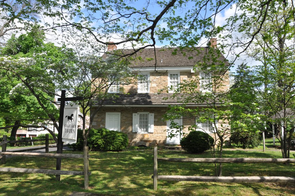
Fallsington Historic District
Monument and historic site · National Register of Historic Places · 2.9 mi
Historic district in Pennsylvania, United States
Gershom Craft House
Monument and historic site · National Register of Historic Places · 4.8 mi
Historic house in Pennsylvania, United States

Harewood and Beechwood
Monument and historic site · National Register of Historic Places · 3.7 mi
Historic house in Pennsylvania, United States

Harriman Historic District
Monument and historic site · National Register of Historic Places · 3.1 mi
Historic district in the United States

Hulmeville Historic District
Monument and historic site · National Register of Historic Places · 3.1 mi
Historic district in Pennsylvania, United States


Jefferson Avenue School
Monument and historic site · National Register of Historic Places · 3.6 mi
School building in Bristol, United States of America
17 more on the map.
Parks, trails and playgrounds33



21 more on the map.
Restaurants and cafes70

Bertucci's
Restaurant · Pizza, Italian · 2.5 mi
675 Middletown Boulevard, Langhorne
Mo-Th 11:30-21:30; Fr-Sa 11:30-22:30; Su 11:30-21:00
Chili's
Restaurant · Tex-Mex · 2.5 mi
610 Commerce Boulevard, Fairless Hills
Mo-Th,Su 11:00-22:00; Fr-Sa 11:00-23:00
Giovanni's Pizzeria
Restaurant · Pizza · 1.8 mi
928 Woodbourne Rd, Levittown
Mo-Th 10:30-22:00; Fr,Sa 10:30-23:00; Su 11:30-22:00
Margaritas
Restaurant · Mexican · 2.5 mi
198 North Bucks Town Drive, Langhorne
Mo-Th 11:00-23:00; Fr-Sa 11:00-24:00; Su 11:00-22:00

Miller's Ale House
Diner · American · 2.4 mi
2250 Lincoln Highway, Langhorne
Mo-Th 11:00-01:00, Fr-Sa 11:00-02:00, Su 11:00-24:00
Mission BBQ
Restaurant · Barbecue · 2.5 mi
636 Commerce Boulevard, Fairless Hills
Mo-Sa 11:00-21:00; Su 11:30-20:00
Olive Garden
Restaurant · Italian · 2.3 mi
2245 East Lincoln Highway, Langhorne
Mo-Th,Su 11:00-22:00; Fr-Sa 11:00-23:00
Outback Steakhouse
Restaurant · American, Steak · 2.6 mi
650 Commerce Boulevard, Fairless Hills
Mo-Th 11:00-21:30; Fr-Sa 11:00-22:30; Su 11:00-21:00
Red Lobster
Restaurant · Seafood · 2.3 mi
2275 East Lincoln Highway, Langhorne
Mo-Th,Su 11:00-22:00; Fr-Sa 11:00-23:00
Slacks Hoagie Shack
Restaurant · 2.1 mi
American restaurant in Fairless Hills
110 Lincoln Highway, Fairless Hills
Mo-Th, Su 10:00-20:00; Fr, Sa 10:00-21:00
Sports Pizza By Kio
Restaurant · Pizza, Italian, Sandwich, Wings · 1.5 mi
1572 Haines Road, Levittown
Mo-Th 11:00-22:00; Fr-Sa 11:00-23:00; Su 12:00-22:00
58 more on the map.
History
Most of the land on which Levittown is built was purchased in 1951. Levitt and Sons only built six models of houses in Levittown, all single-family dwellings with lawns: the Levittowner, the Rancher, the Jubilee, the Pennsylvanian, the Colonial and the Country Clubber, with only modest exterior variations within each model. The homes were moderately priced and required only a low down payment.
Construction of Levittown began in February 1952, soon after completion of Levittown, New York, located on Long Island. Levittown, Pennsylvania, was the second "Levittown" built by William J. Levitt, who is often credited as the creator of the modern American suburb.
To speed up construction, Levitt & Sons perfected a 26-step rationalized building method that was essentially an assembly line type of home building. The house remained stationary while construction workers moved from site to site, each repeatedly performing a task such as pouring foundations, putting up pre-fabricated walls, installing plumbing, or doing electrical work. At peak production, this highly regimented process enabled Levitt's workers to produce a finished house every sixteen minutes. Construction of the homes commenced in 1952 and when completed in 1958, 17,311 homes had been built.
From the History section of Levittown, Pennsylvania on Wikipedia, under CC BY-SA 4.0.
Where to stay12
SpringHill Suites Philadelphia Langhorne
Motel and hotel · 2.6 mi
200 North Bucks Town Drive, Langhorne
Motel 6 Levittown, PA - Bensalem
Motel and hotel · 2.1 mi
6401 Bristol Pike, Levittown
Churches and places of worship22
The Church of Saint Michael the Archangel
Church · Roman Catholic · 1.9 mi
66 Levittown Parkway, Levittown
Our Lady of Perpetual Help Byzantine Catholic Church
Place of worship · 0.9 mi
1773 Woodbourne Road, Levittown
Faith Presbyterian Church
Church · Presbyterian · 1.7 mi
525 South Olds Boulevard, Fairless Hills
Shopping20
Gas and EV charging21
Schools, colleges and libraries70
Healthcare8
Map of Levittown
250 places. The map loads OpenStreetMap tiles when you open it.
Climate by month
Monthly table
| Month | High | Low | Rain | Snow |
|---|---|---|---|---|
| Jan | 39°F | 22°F | 3.7 in | 7.0 in |
| Feb | 42°F | 23°F | 3.1 in | 5.7 in |
| Mar | 50°F | 29°F | 4.6 in | 3.5 in |
| Apr | 62°F | 40°F | 4.0 in | 0.0 in |
| May | 72°F | 50°F | 4.0 in | 0.0 in |
| Jun | 81°F | 60°F | 4.6 in | 0.0 in |
| Jul | 86°F | 65°F | 4.9 in | 0.0 in |
| Aug | 84°F | 64°F | 4.7 in | 0.0 in |
| Sep | 77°F | 56°F | 4.7 in | 0.0 in |
| Oct | 66°F | 44°F | 4.2 in | 0.1 in |
| Nov | 55°F | 33°F | 3.6 in | 0.2 in |
| Dec | 44°F | 26°F | 4.7 in | 3.4 in |
U.S. Climate Normals 1991-2020 for Neshaminy Falls (5 mi away), NOAA NCEI.
People and cost of living
American Community Survey 5-year estimates, 2020-2024, U.S. Census Bureau. Estimates have margins of error, larger for small towns.
Disaster history
Bucks County has had 17 federal disaster declarations since 2000, most often for hurricanes.
- 2021-09-10: Remnants Of Hurricane Ida (Hurricane)
- 2020-03-30: Covid-19 Pandemic (Biological)
- 2020-03-13: Covid-19 (Biological)
- 2016-03-23: Severe Winter Storm And Snowstorm (Snowstorm)
- 2014-02-06: Severe Winter Storm (Severe Ice Storm)
- 2013-01-10: Hurricane Sandy (Hurricane)
OpenFEMA disaster declarations summaries.
Getting there and nearby towns
Trenton Mercer Airport (TTN) is the nearest airport with scheduled flights listed in OpenStreetMap, 9 miles away.
- Trenton 7 mi northeast, about 11 min by car
- White Horse 8 mi east, about 14 min by car
- Mercerville 10 mi northeast, about 16 min by car
- Hamilton Square 12 mi northeast, about 19 min by car
- Moorestown-Lenola 14 mi southwest, about 23 min by car
- Horsham 15 mi west, about 25 min by car
- Princeton 17 mi northeast, about 28 min by car
- Cherry Hill Mall 17 mi southwest, about 27 min by car
- Philadelphia 18 mi southwest, about 29 min by car
- Marlton 18 mi south, about 29 min by car
Drive times are estimates from straight-line distance, not routes.
Local news
Headlines from INDB, the NEMICO news database.
Reviews, tips and questions
Loading what members have shared...
Sources and licences
- NCES EDGE (Public domain): public schools
- NOAA NCEI U.S. Climate Normals 1991-2020 (Public domain): climate by month
- OpenFEMA (Public domain): disaster declarations
- OpenStreetMap contributors (ODbL 1.0): places, airports, map data
- U.S. Census Bureau (Public domain): population, income, housing, education, commute
- Wikidata (CC0 1.0): elevation, founding date, time zone, website, landmarks and historic places
- Wikimedia Commons (see each image): photos
- Wikipedia (CC BY-SA 4.0): overview and history text
Photo credits
- LevittownPA, Unknown author, Public domain
- Levittown Town Center, Delaware Canal Towpath, Tullytown, PA - 2026, Zeete, CC BY-SA 4.0
- Delaware Canal State Park, Levittown Parkway, Tullytown, PA - 2026, Zeete, CC BY-SA 4.0
- 2022-07-30 17 34 08 View north along Interstate 95 (Pennsylvania Turnpike Delaware River Extension) at Exit 42 (U.S. Route 13, Levittown, Bristol) in Bristol Township, Bucks County, Pennsylvania, Famartin, CC BY-SA 4.0
- 2022-10-16 09 40 41 View south along U.S. Route 13 (Bristol Pike) just south of Levittown Parkway in Tullytown, Bucks County, Pennsylvania, Famartin, CC BY-SA 4.0
- Levittown station from US 13, Tullytown, PA, Aug. 2026, Mr. Matté (if there is an issue with this image, contact me using this image's Commons talk page , my Commons user talk page , or my English Wikipedia user talk page ; I'll know about it a lot faster), CC BY-SA 4.0
- US 13 NB past Levittown Parkway, Dough4872, CC BY-SA 4.0
- 2022-10-18 15 53 48 View north along U.S. Route 13 (Bristol Pike) just north of Levittown Parkway in Tullytown, Bucks County, Pennsylvania, Famartin, CC BY-SA 4.0
- 2018-09-23 15 42 44 View north along Interstate 95 (Pennsylvania Turnpike Delaware River Extension) at Exit 42 (U.S. Route 13, Levittown, Bristol) in Bristol Township, Bucks County, Pennsylvania, Famartin, CC BY-SA 4.0
- 2020-07-09 13 47 09 View north along Interstate 95 (Pennsylvania Turnpike Delaware River Extension) just south of Exit 42 (U.S. Route 13, Levittown, Bristol) in Bristol Township, Bucks County..., Famartin, CC BY-SA 4.0
- 2022-07-30 17 32 40 View north along Interstate 95 (Pennsylvania Turnpike Delaware River Extension) just south of Exit 42 (U.S. Route 13, Levittown, Bristol) in Bristol Township, Bucks County..., Famartin, CC BY-SA 4.0
- SEPTA Station Levittown PA, Robert Mortell, CC BY-SA 3.0
- Levittown SEPTA station November 2019, Dough4872, CC BY-SA 4.0
- Levittown station from Fallsington Avenue, Tullytown, PA, Aug. 2026, Mr. Matté (if there is an issue with this image, contact me using this image's Commons talk page , my Commons user talk page , or my English Wikipedia user talk page ; I'll know about it a lot faster), CC BY-SA 4.0
- 2022-07-30 08 15 30 View south along Interstate 95 (Pennsylvania Turnpike Delaware River Extension) at Exit 42 (U.S. Route 13, Levittown, Bristol) in Bristol Township, Bucks County, Pennsylvania, Famartin, CC BY-SA 4.0
- TullytownPA WaltDisneyElementarySchool, User:Magicpiano, CC BY-SA 4.0
- Pennsbury Manor 01, Shuvaev, CC BY-SA 3.0
- Dorrance Bristol, Smallbones, Public domain
- Harriman historic district, Marduk, CC0
- Langhorne HD 14, Hshuvaeva, CC BY-SA 3.0
- Jefferson Land Bristol, Smallbones, Public domain
- Amos Palmer House, Langhorne, PA 01, Hshuvaeva, CC BY-SA 3.0
- Edgemont HABS Photo, Jack E. Boucher, photographer, Public domain
- Industrial 1, Smallbones, Public domain
- Tomlinson-Huddleston House 01, Hshuvaeva, CC BY-SA 3.0
- FairlessHillsPA SotcherFarmhouse, User:Magicpiano, CC BY-SA 4.0
- Bristol Friends, Smallbones, Public domain
- FallsingtonPA StageCoachTavern, User:Magicpiano, CC BY-SA 4.0
- Langhorne Library 02, Hshuvaeva, CC BY-SA 3.0
- MiddletownTwpPA Beechwood, User:Magicpiano, CC BY-SA 4.0
- Jeff School Bristol, Smallbones, Public domain
- BristolPA PhineasPembertonHouse, User:Magicpiano, CC BY-SA 4.0
- Hulmeville Borough Hall, Marduk, CC0
- Woody Jeff, DahnDynasty, CC BY-SA 4.0
- Dogwood Hollow, OldsVistaCruiser, CC BY-SA 4.0
- Three Arches house, Fairless Hills, PA, Dec. 2025, Mr. Matté (if there is an issue with this image, contact me using this image's Commons talk page , my Commons user talk page , or my English Wikipedia user talk page ; I'll know about it a lot faster), CC BY-SA 4.0
- 2022-10-16 09 43 13 View south along U.S. Route 13 (Bristol Pike) just south of Haines Road in Bristol Township, Bucks County, Pennsylvania, Famartin, CC BY-SA 4.0
- Lock 4, Delaware Canal, Bristol Township, PA - 2025, Zeete, CC BY-SA 4.0
- Mitre Gates, Lock 4, Delaware Canal, Bristol Township, PA - 2025, Zeete, CC BY-SA 4.0
- 2020-07-12 09 43 30 View south along Interstate 95 (Pennsylvania Turnpike Delaware River Extension) 1 mile north of Exit 40 (Interstate 276 WEST-Pennsylvania Turnpike, Harrisburg) in Bristol..., Famartin, CC BY-SA 4.0


Page built October 30, 2026. Spotted a mistake? Tell us or suggest a place.