


Lexington, Virginia
Lexington is a city of 7,525 people in Lexington city, Virginia, founded in 1777.
Why visit Lexington
Townapedia lists 51 museums and landmarks, 12 parks and trails, 49 places to eat, 9 places to stay and 5 attractions in and around town.
Highlights include State Movies 3, Lime Kiln Theatre, Lexington Historic District and Stonewall Jackson House.
July is the warmest month, with average highs of 87°F; January lows average 23°F.
Weather in Lexington
Forecast from the National Weather Service. Full forecast
About Lexington
Lexington is an independent city in the Commonwealth of Virginia, United States. At the 2020 census, the population was 7,320. It is the county seat of Rockbridge County, although the two are separate jurisdictions, and is combined with it for statistical purposes by the Bureau of Economic Analysis. Lexington is within the Shenandoah Valley about 57 miles (92 km) east of the West Virginia border and is about 50 miles (80 km) north of Roanoke, Virginia.
From the Wikipedia article Lexington, Virginia (this version), under CC BY-SA 4.0.
Things to do5


Museums and landmarks51

Lexington Historic District
Monument and historic site · National Register of Historic Places
Listed on the NRHP in Lexington, Virginia
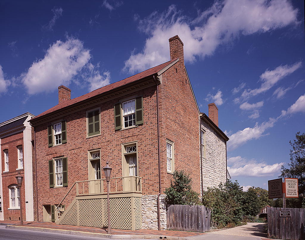
Stonewall Jackson House
Monument and historic site · National Register of Historic Places
Historic house in Virginia, United States

Virginia Military Institute Historic District
Monument and historic site · National Register of Historic Places · 0.7 mi
Historic district in Lexington, Virginia, USA
Alexander-Withrow House
Monument and historic site · National Register of Historic Places
United States historic place
Blandome
Monument and historic site · National Register of Historic Places
Historic house in Virginia, United States
Clifton
Monument and historic site · National Register of Historic Places · 1.5 mi
Historic house near Lexington, Virginia, United States
Col Alto
Monument and historic site · National Register of Historic Places
Historic building in Lexington, Virginia
Jordan's Point Historic District
Monument and historic site · National Register of Historic Places · 1.0 mi
Historic district in Virginia, United States
Lexington and Covington Turnpike Toll House
Monument and historic site · National Register of Historic Places · 0.6 mi
House in Lexington, United States of America
Lylburn Downing School
Monument and historic site · National Register of Historic Places · 1.2 mi
School building in Lexington, United States of America
Mulberry Hill
Monument and historic site · National Register of Historic Places · 0.6 mi
Building in Virginia, United States
Reid-White-Philbin House
Monument and historic site · National Register of Historic Places
Historic house in Virginia, United States
39 more on the map.
Parks, trails and playgrounds12





Restaurants and cafes49

Don Tequila
Restaurant · Mexican · 0.4 mi
487 East Nelson Street, Lexington
Mo-Th 11:00-22:00; Fr 11:00-22:30; Sa 12:00-22:30; Su 12:00-22:00
Heliotrope Brewery
Restaurant · Pizza, Salad
130 South Main Street
We 16:00-20:00; Th 16:00-21:00; Fr 16:00-22:00; Sa 12:00-22:00; Su...
Hong Kong Kitchen
Restaurant · Chinese · 0.8 mi
106 East Midland Trail, Lexington
Mo,We-Th,Su 11:00-22:00; Fr-Sa 11:00-22:30
Pizza Hut
Restaurant · Pizza · 0.7 mi
10 Rocklawn Lane, Lexington
Su-Th 10:00-22:00; Fr-Sa 10:00-00:00



37 more on the map.
History
Lexington was named in 1778. It was the second of what would be many American places named after Lexington, Massachusetts, known for being the place at which the first shot was fired in the American Revolution.
The Union General David Hunter led a raid on Virginia Military Institute during the American Civil War. Robert E. Lee and Thomas "Stonewall" Jackson are buried in the city. It is the site of the only house Jackson ever owned, now open to the public as a museum. Cyrus McCormick invented the horse-drawn mechanical reaper at his family's farm in Rockbridge County, and a statue of McCormick is located on the Washington and Lee University campus. McCormick Farm is now owned by Virginia Tech and is a satellite agricultural research center.
From the History section of Lexington, Virginia on Wikipedia, under CC BY-SA 4.0.
Where to stay9
Churches and places of worship18
First Baptist Church
Church · Baptist · National Register of Historic Places
103 North Main Street, Lexington
Lexington Presbyterian Church
Church · National Register of Historic Places
Lauderdale Associate Reformed Presbyterian Church
Church · Presbyterian
300 South Main Street, Lexington
Gospel Way Church of God in Christ
Church · Church Of God In Christ
109 East Henry Street, Lexington
Shopping19
Gas and EV charging7
Schools, colleges and libraries20
Healthcare8
Virginia Military Institute Health Center
Clinic and pharmacy · 0.9 mi
448 Institute Hill, Lexington
Map of Lexington
198 places. The map loads OpenStreetMap tiles when you open it.
Climate by month
Monthly table
| Month | High | Low | Rain | Snow |
|---|---|---|---|---|
| Jan | 45°F | 23°F | 3.1 in | 2.9 in |
| Feb | 49°F | 25°F | 2.8 in | 4.7 in |
| Mar | 57°F | 31°F | 3.5 in | 2.3 in |
| Apr | 68°F | 40°F | 3.7 in | 0.1 in |
| May | 76°F | 50°F | 4.1 in | 0.0 in |
| Jun | 83°F | 59°F | 4.8 in | 0.0 in |
| Jul | 87°F | 64°F | 4.1 in | 0.0 in |
| Aug | 85°F | 63°F | 3.3 in | 0.0 in |
| Sep | 79°F | 56°F | 3.7 in | 0.0 in |
| Oct | 69°F | 43°F | 3.1 in | 0.0 in |
| Nov | 58°F | 32°F | 3.2 in | 0.1 in |
| Dec | 48°F | 26°F | 3.5 in | 3.4 in |
U.S. Climate Normals 1991-2020 for Lexington Hcn (0 mi away), NOAA NCEI.
People and cost of living
American Community Survey 5-year estimates, 2020-2024, U.S. Census Bureau. Estimates have margins of error, larger for small towns.
Disaster history
Lexington city has had 7 federal disaster declarations since 2000, most often for hurricanes.
- 2026-01-23: Severe Winter Storm (Winter Storm)
- 2020-04-02: Covid-19 Pandemic (Biological)
- 2020-03-13: Covid-19 (Biological)
- 2018-09-11: Hurricane Florence (Hurricane)
- 2012-10-29: Hurricane Sandy (Hurricane)
- 2012-07-27: Severe Storms And Straight-Line Winds (Severe Storm)
OpenFEMA disaster declarations summaries.
Getting there and nearby towns
Ingalls Field (HSP) is the nearest airport with scheduled flights listed in OpenStreetMap, 24 miles away.
- East Lexington 2 mi northeast, about 3 min by car
- Buena Vista 6 mi southeast, about 10 min by car
- Glasgow 10 mi south, about 17 min by car
- Clifton Forge 21 mi west, about 34 min by car
- Craigsville 21 mi north, about 34 min by car
- Greenville 22 mi northeast, about 35 min by car
- Buchanan 23 mi southwest, about 36 min by car
- Amherst 26 mi southeast, about 41 min by car
- Stuarts Draft 28 mi northeast, about 45 min by car
- Lynchburg 30 mi southeast, about 48 min by car
Drive times are estimates from straight-line distance, not routes.
Local news
Headlines from INDB, the NEMICO news database.
Reviews, tips and questions
Loading what members have shared...
Sources and licences
- NCES EDGE (Public domain): public schools
- NOAA NCEI U.S. Climate Normals 1991-2020 (Public domain): climate by month
- OpenFEMA (Public domain): disaster declarations
- OpenStreetMap contributors (ODbL 1.0): places, airports, map data
- U.S. Census Bureau (Public domain): population, income, housing, education, commute
- Wikidata (CC0 1.0): elevation, founding date, time zone, website, landmarks and historic places
- Wikimedia Commons (see each image): photos
- Wikipedia (CC BY-SA 4.0): overview and history text
Photo credits
- South Main Street, Lexington, VA - looking north, Zeete, CC BY-SA 4.0
- 2017-06-13 19 00 25 View north along U.S. Route 11 Business (Main Street) between McDowell Street and Preston Street in Lexington, Virginia, Famartin, CC BY-SA 4.0
- 202 South Main Street, Lexington, VA - Manly Memorial Baptist Church, Zeete, CC BY-SA 4.0
- 2018-10-27 17 18 50 View north along U.S. Route 11 Business (Main Street) just south of U.S. Route 60 (Nelson Street) in Lexington, Virginia, Famartin, CC BY-SA 4.0
- 2018-10-27 17 19 12 View north along U.S. Route 11 Business (Main Street) just south of U.S. Route 60 (Nelson Street) in Lexington, Virginia, Famartin, CC BY-SA 4.0
- Lexington Presbyterian Church, Lexington, VA - view from South Main Street, Zeete, CC BY-SA 4.0
- 2017-06-13 19 00 54 View north along U.S. Route 11 Business (Main Street) at Nelson Street in Lexington, Virginia, Famartin, CC BY-SA 4.0
- Stonewall Jackson Monument, Oak Grove Cemetery, Lexington, VA, Zeete, Public domain
- Odd Fellows Rockbridge Lodge No. 58 11 East Nelson Street Lexington VA April 2023, Artaxerxes, CC BY-SA 4.0
- Lexington Presbyterian Church at night, Taber Andrew Bain, CC BY 2.0
- The Palms restaurant 101 West Nelson Street Lexington VA April 2023, Artaxerxes, CC BY-SA 4.0
- World War I German field gun 2 South Main Street downtown Lexington VA April 2023 rear, Artaxerxes, CC BY-SA 4.0
- World War I German field gun 2 South Main Street downtown Lexington VA April 2023 right, Artaxerxes, CC BY-SA 4.0
- VMI cadets W Nelson and S Jefferson Streets downtown Lexington VA April 2023, Artaxerxes, CC BY-SA 4.0
- World War I German field gun 2 South Main Street downtown Lexington VA April 2023 left, Artaxerxes, CC BY-SA 4.0
- The Gin Hotel 30 South Main Street Lexington VA April 2023, Artaxerxes, CC BY-SA 4.0
- Brennan Gilmore Gary Ruley and Mule Train Southern Inn Lexington VA December 2008, Artaxerxes, CC BY-SA 3.0
- 6 South Randolph Street, Lexington, VA - The Castle, Zeete, CC BY-SA 4.0
- Gary Ruley with Gary Ruley and Mule Train Southern Inn Main Street downtown Lexington VA December 2008, Artaxerxes, CC BY-SA 3.0
- Will Lee David Knicely Gary Ruley and Mule Train Southern Inn Lexington VA December 2008, Artaxerxes, CC BY-SA 3.0
- Danny Knicely plays with Gary Ruley and Mule Train Southern Inn Lexington VA December 2008, Artaxerxes, CC BY-SA 3.0
- Brennan Gilmore on mandolin Gary Ruley and Mule Train Southern Inn Lexington VA December 2008, Artaxerxes, CC BY-SA 3.0
- The Castle, Lexington, VA - history plaque, Zeete, CC BY-SA 4.0
- Southern Inn restaurant 37 South Main Street downtown Lexington VA July 2022, Artaxerxes, CC BY-SA 4.0
- 1. NORTH MAIN STREET, EAST SIDE, LOOKING NORTHEAST FROM BELOW THE DOLD BUILDING (1 NORTH MAIN STREET) - Main Street Area Survey, Lexington, Lexington, VA, Unknown author Unknown author, Public domain
- 2017-06-13 19 01 26 View north along U.S. Route 11 Business (Main Street) at Washington Street in Lexington, Virginia, Famartin, CC BY-SA 4.0
- German World War I field gun 2 South Main Street downtown Lexington VA July 2022, Artaxerxes, CC BY-SA 4.0
- The Stonewall Jackson House 8 East Washington Street Lexington VA April 2023 02, Artaxerxes, CC BY-SA 4.0
- Historical plaque The Stonewall Jackson House 8 East Washington Street Lexington VA April 2023, Artaxerxes, CC BY-SA 4.0
- The Stonewall Jackson House 8 East Washington Street Lexington VA April 2023 01, Artaxerxes, CC BY-SA 4.0
- North Main Street, Lexington, VA - from Washington Street intersection, Zeete, CC BY-SA 4.0
- The Red Hen restaurant 11 East Washington Street downtown Lexington VA April 2023, Artaxerxes, CC BY-SA 4.0
- Stonewall Jackson Home, Lexington, Virginia (10475890636), Gary Todd from Xinzheng, China, CC0
- Stonewall Jackson House, Lexington, Virginia (10476051514), Gary Todd from Xinzheng, China, CC0
- Patsy Cline sidewalk plaque downtown Lexington VA April 2023, Artaxerxes, CC BY-SA 4.0
- Washington and Lee University W Washington N Jefferson Streets downtown Lexington VA April 2023, Artaxerxes, CC BY-SA 4.0
- Greetings from Lexington, Virginia - Large Letter Postcard (8438082650), Steve Shook from Moscow, Idaho, USA, CC BY 2.0
- Stonewall Jackson House, Carol M. Highsmith, Public domain
- 2008-0831-VMI-ParadeGround, Bobak Ha'Eri, CC BY 3.0
- Lexington First Baptist Church, Nyttend, Public domain


Page built October 30, 2026. Spotted a mistake? Tell us or suggest a place.