


Coon Rapids, Minnesota
Coon Rapids is a city of 63,468 people in Anoka County, Minnesota.
Why visit Coon Rapids
Townapedia lists 12 museums and landmarks, 133 parks and trails, 170 places to eat, 12 places to stay and 7 attractions in and around town.
Highlights include Anoka–Champlin Mississippi River Bridge, AMC Coon Rapids 16, Anoka Post Office and Colonial Hall and Masonic Lodge No. 30.
July is the warmest month, with average highs of 82°F; January lows average 2°F, and about 44 inches of snow fall in a normal year.
Weather in Coon Rapids
Forecast from the National Weather Service. Full forecast
About Coon Rapids
Coon Rapids is a northern suburb of Minneapolis, and the second-largest city by population in Anoka County, Minnesota, United States. The population was 63,599 at the 2020 census, making it Minnesota's 15th-largest city and the seventh-largest Twin Cities suburb.
From the Wikipedia article Coon Rapids, Minnesota (this version), under CC BY-SA 4.0.
Things to do7

Anoka–Champlin Mississippi River Bridge
Bridge · National Register of Historic Places · 4.2 mi
Highway bridge across the Mississippi River between Anoka, Minnesota and Champlin, Minnesota


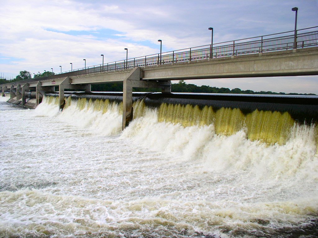
Coon Rapids Dam
Bridge · 2.2 mi
Dam on the Mississippi River, Minnesota, United States of America
Richard P. Braun Bridge
Bridge · 3.3 mi
Highway bridge across the Mississippi River between Brooklyn Park, Minnesota and Coon Rapids, Minnesota

Museums and landmarks12

Anoka Post Office
Monument and historic site · National Register of Historic Places · 4.0 mi
Former post office building in Anoka, Minnesota, United States

Colonial Hall and Masonic Lodge No. 30
Monument and historic site · National Register of Historic Places · 3.9 mi
House in Anoka, United States of America

District No. 28 School
Monument and historic site · National Register of Historic Places · 5.5 mi
Historic school building in Ramsey, Minnesota, United States
Heman L. Ticknor House
Monument and historic site · National Register of Historic Places · 3.9 mi
Historic house in Anoka, Minnesota, United States
Jackson Hotel
Monument and historic site · National Register of Historic Places · 4.0 mi
Listed on the National Register of Historic Places in Anoka County, Minnesota
Shaw–Hammons House
Monument and historic site · National Register of Historic Places · 4.3 mi
Oldest standing residential building in Anoka, Minnesota, United States


Windego Park Auditorium/Open Air Theater
Monument and historic site · National Register of Historic Places · 4.2 mi
Amphitheatre in Anoka, United States of America
Osseo Water Tower
Monument and historic site · National Register of Historic Places · 5.9 mi
Parks, trails and playgrounds133

Bunker Hills Golf Course
Golf course · 2.4 mi
12800 Bunker Prairie Road NW, Coon Rapids
sunrise-sunset

Andrews Park (Champlin, Minnesota)
Park · 3.1 mi
Park in Minnesota, United States of America


Doris A. Kemp Park
Park · 3.9 mi
Pretty green park with flower beds, a picnic area & gazebo beside a fishing & boating lake.
921 HWY 169, Champlin
121 more on the map.
Restaurants and cafes170

Hajime Restaurant & Lounge Bar
Restaurant · Japanese, Asian, Sushi · 3.9 mi
Japanese Restaurant
10950 Club West Parkway #220, Blaine
Aladdin Grill - Mediterranean & American Food
Restaurant · American, Mediterranean · 0.4 mi
2022 Northdale Boulevard Northwest
Mo-Sa 10:30-21:00; Su 10:30-20:00
Angkor Restaurant
Restaurant · 1.6 mi
Chinese and Cambodian Restaurant
506 Northdale BLVD NW
Tu-Su 12:00-19:00

Anoka Hardware Store
Bar and pub · Burger, Local, Tea · 4.1 mi
201 Jackson Street
We 16:00-22:00; Th 17:00-22:00; Fr 16:00-23:00; Sa 15:00-23:00

Caribou Coffee
Cafe · Coffee Shop · 3.9 mi
10400 Baltimore Street Northeast, Blaine
Mo-Th 05:30-21:00; Fr 05:30-22:00; Sa 06:30-22:00; Su 06:30-21:00
Chili Lime
Restaurant · Mexican, Tacos, Burrito, Comfort Food, Quick Bites · 4.0 mi
12490 Champlin Drive, Champlin
Mo-Su 11:00-20:00

Cold Stone Creamery
Ice cream · Ice Cream · 3.9 mi
10400 Baltimore Street Northeast #150, Blaine
Mo-Th 12:00-21:00; Fr 12:00-22:00; Sa 11:00-22:00; Su 11:00-21:00
Hope Breakfast Bar - Blaine
Restaurant · American, Breakfast, Pancake · 3.9 mi
10950 Club West Parkway Northeast
Sa-Su 07:00-15:00; Mo-Fr 07:00-14:00
Micholandia Ice Cream & Tacos
Restaurant · Ice Cream, Mexican · 4.1 mi
9927 Ulysses Street Northeast, Blaine
Su-Th 11:00-21:00; Fr-Sa 11:00-22:00
Noodles & Company
Restaurant · Pasta · 4.0 mi
10340 Baltimore Street Northeast, Blaine
Mo-Su 10:30-10:00
158 more on the map.
History
Settlers were first attracted to the area by Coon Creek, named for the many raccoons hunted in the 19th century at the mouth of the creek.
In 1835, the Red River Ox Cart Trail was laid to establish military and trade connections between Minneapolis and Anoka. The first industries of Coon Rapids sprung up around the road, including the prominent Anoka Pressed Brick and Terra Cotta Company, founded by D. C. Dunham in 1881. The clay excavation site—known locally as the "Clay Hole"—is one of the lasting reminders of Coon Rapids's industrial history. Today, the vital Red River Ox Cart Trail is known as Coon Rapids Boulevard and remains an important commercial corridor for the city.
In 1912, construction began on the Coon Rapids Dam and the influx of laborers and engineers increased the city's population to over 1,000 for the first time. Completed in 1914, the dam functioned as a regional power source for the Northern States Power Company until it was sold to the Hennepin County Park Board in 1969 and incorporated into the Coon Rapids Dam Regional Park.
When the dam was built, Anoka Township renamed itself Coon Creek Rapids, later shortened to Coon Rapids. In 1959, the Village of Coon Rapids voted to incorporate as a city and the City of Coon Rapids was born. The city's population increased from 14,000 in 1959 to more than 62,785 in 2022, making it the 15th-largest city in Minnesota.
From the History section of Coon Rapids, Minnesota on Wikipedia, under CC BY-SA 4.0.
Where to stay12
AmericInn by Wyndham Coon Rapids
Motel and hotel · 2.9 mi
3430 Northdale Boulevard Northwest, Coon Rapids
Best Western Plus Blaine At the National Sports Center
Motel and hotel · 3.9 mi
10580 Baltimore Street Northeast, Blaine
Country Inn & Suites, Coon Rapids, MN
Motel and hotel · 3.3 mi
155 Coon Rapids Boulevard Northwest, Coon Rapids
Fairfield Inn & Suites Minneapolis North/Blaine
Motel and hotel · 4.0 mi
10643 Baltimore Street Northeast, Blaine
Holiday Inn Express & Suites Coon Rapids-Blaine Area
Motel and hotel · 3.2 mi
9333 Springbrook Drive Northwest, Coon Rapids
Quality Inn
Motel and hotel · 3.6 mi
9052 University Avenue Northeast, Coon Rapids
Churches and places of worship19
Reedemer Lutheran Church
Church · Lutheran · 0.7 mi
2135 Northdale Boulevard Northwest, Coon Rapids
United Methodist Church- Anoka
Church · Methodist · 3.2 mi
850 South Street, Anoka
Believers Bible Chapel
Church · 2.2 mi
11024 University Avenue Northeast, Coon Rapids
Shopping33
Gas and EV charging26
Schools, colleges and libraries62
DaVinci Academy of Arts and Science
School · All · 3.9 mi
532 Bunker Lake Boulevard Northeast NE, Ham Lake
Anoka-Hennepin Regn Hs Summer Prog
School · 1.7 mi
1313 Coon Rapids Blvd Nw, Coon Rapids
Athlos Leadership Academy
School · 2.9 mi
10100 Noble Parkway North, Brooklyn Park
Healthcare26
Action Behavior Centers - ABA Therapy for Autism
Clinic and pharmacy · 2.5 mi
3777 Coon Rapids Blvd NW, coon rapids
Action Behavior Centers - ABA Therapy for Autism
Clinic and pharmacy · 3.7 mi
11855 Ulysses Street Northeast, Blaine
Action Behavior Centers - ABA Therapy for Autism
Clinic and pharmacy · 3.9 mi
6001 96th Lane North, Brooklyn Park
Allina Health Mercy Pharmacy
Clinic and pharmacy · 2.9 mi
11850 Blackfoot Street Northwest, Coon Rapids
Allina Health Clinic
Clinic and pharmacy · 3.4 mi
9055 Springbrook Drive Northwest, Coon Rapids
Map of Coon Rapids
250 places. The map loads OpenStreetMap tiles when you open it.
Climate by month
Monthly table
| Month | High | Low | Rain | Snow |
|---|---|---|---|---|
| Jan | 22°F | 2°F | 0.6 in | 5.1 in |
| Feb | 28°F | 7°F | 0.8 in | 9.6 in |
| Mar | 41°F | 19°F | 1.4 in | 6.3 in |
| Apr | 56°F | 32°F | 2.9 in | 5.7 in |
| May | 68°F | 45°F | 3.6 in | 0.0 in |
| Jun | 78°F | 55°F | 3.8 in | 0.0 in |
| Jul | 82°F | 60°F | 4.5 in | 0.0 in |
| Aug | 80°F | 57°F | 3.6 in | 0.0 in |
| Sep | 72°F | 48°F | 2.5 in | 0.0 in |
| Oct | 58°F | 36°F | 2.7 in | 0.7 in |
| Nov | 41°F | 23°F | 1.4 in | 4.3 in |
| Dec | 27°F | 11°F | 1.0 in | 12.4 in |
U.S. Climate Normals 1991-2020 for Andover 1N (5 mi away), NOAA NCEI.
People and cost of living
American Community Survey 5-year estimates, 2020-2024, U.S. Census Bureau. Estimates have margins of error, larger for small towns.
Disaster history
Anoka County has had 6 federal disaster declarations since 2000, most often for biologicals.
- 2020-04-07: Covid-19 Pandemic (Biological)
- 2020-03-13: Covid-19 (Biological)
- 2011-06-07: Severe Storms And Tornadoes (Severe Storm)
- 2005-09-13: Hurricane Katrina Evacuation (Hurricane)
- 2001-05-16: Severe Winter Storms, Flooding, And Tornadoes (Flood)
- 2000-10-20: Mn - Carlos Edge Fire Complex - 10/19/2000 (Fire)
OpenFEMA disaster declarations summaries.
Getting there and nearby towns
Crystal Airport (MIC) is the nearest airport with scheduled flights listed in OpenStreetMap, 8 miles away.
- Champlin 4 mi west, about 6 min by car
- Brooklyn Park 5 mi south, about 8 min by car
- Anoka 5 mi northwest, about 8 min by car
- Blaine 5 mi east, about 8 min by car
- Andover 5 mi north, about 9 min by car
- Brooklyn Center 7 mi south, about 12 min by car
- Columbia Heights 9 mi south, about 15 min by car
- Minneapolis 15 mi south, about 24 min by car
- St. Paul 19 mi southeast, about 30 min by car
- Bloomington 24 mi south, about 39 min by car
Drive times are estimates from straight-line distance, not routes.
Local news
Headlines from INDB, the NEMICO news database.
Reviews, tips and questions
Loading what members have shared...
Sources and licences
- NCES EDGE (Public domain): public schools
- NOAA NCEI U.S. Climate Normals 1991-2020 (Public domain): climate by month
- OpenFEMA (Public domain): disaster declarations
- OpenStreetMap contributors (ODbL 1.0): places, airports, map data
- U.S. Census Bureau (Public domain): population, income, housing, education, commute
- Wikidata (CC0 1.0): elevation, founding date, time zone, website, landmarks and historic places
- Wikimedia Commons (see each image): photos
- Wikipedia (CC BY-SA 4.0): overview and history text
Photo credits
- Coon Rapids Dam, McGhiever, CC BY-SA 3.0
- Michael Izen at Epiphany, Coon Rapids, Darth Stabro, CC BY-SA 4.0
- Coon Rapids, MN, USA - panoramio, Andrew Balfour, CC BY 3.0
- Northstar Commuter Coon Rapids Riverdale station, Mulad, Public domain
- Coon Rapids Dam 2021-03-28, August Schwerdfeger, CC BY 4.0
- Coon Rapids banner, August Schwerdfeger, CC BY 4.0
- Summer Ride on Coon Rapids Dam - panoramio, Wylbur, CC BY-SA 3.0
- Bike Ride at Coon Rapids Dam - panoramio, Wylbur, CC BY-SA 3.0
- Coon Rapids Dam October 2025, Milonica, CC BY 4.0
- Mercy Hospital, Coon Rapids, Minnesota, Widgetkid, CC BY-SA 4.0
- Windego Park 1, Elkman, CC BY-SA 3.0
- Anoka-Champlin Bridge, McGhiever, CC BY 4.0
- District 28 School 3, Elkman, CC BY-SA 3.0
- Anoka Post Office, McGhiever, CC BY-SA 4.0
- 1941 Eucharistic Congress pin, Darth Stabro, CC BY-SA 4.0
- Last train to Big Lake, chief_huddleston, CC BY 2.0
- Sunset - panoramio - Andrew Balfour, Andrew Balfour, CC BY 3.0
- Coon Creek Speed - panoramio, Wylbur, CC BY-SA 3.0
- ISS065-E-85831 - View of Earth, Earth Science and Remote Sensing Unit , Lyndon B. Johnson Space Center, Public domain
- ISS018-E-16176 - View of Earth, Earth Science and Remote Sensing Unit , Lyndon B. Johnson Space Center, Public domain
- Coon Creek trail - panoramio, Andrew Balfour, CC BY 3.0
- Coon Creek Train Bridge - panoramio, Andrew Balfour, CC BY 3.0
- Al Flynn Pond - panoramio, Andrew Balfour, CC BY 3.0
- Mississippi River Trail - panoramio (1), Gabriel Vanslette, CC BY 3.0
- CompaqPortableIII, Rwallmow, CC BY-SA 3.0
- IBM Simon in leather case, RWallmow, CC BY-SA 3.0
- Mississippi River Trail - panoramio, Gabriel Vanslette, CC BY 3.0
- CompaqPortableII, Rwallmow, CC BY-SA 3.0
- Dunning School, McGhiever, CC BY-SA 4.0
- Elevator Door Piece, CrownIron, CC BY-SA 4.0
- Perdita dolichocephala, iNaturalist user: gonodactylus, CC BY 4.0
- Strobilomyces strobilaceus 30161300, jenniferf4, CC0
- Sunset at Bunker Hills Regional Park Minnesota (29316156750), Tony Webster from Minneapolis, Minnesota, CC BY-SA 2.0
- RV Surge Protector EMS-PT30X Progressive Industries (53243778830), Tony Webster, CC BY 2.0
- Bunker Hills Regional Park, Minnesota (35331432836), Tony Webster from Minneapolis, Minnesota, United States, CC BY-SA 2.0
- Eidem Homestead, McGhiever, CC BY-SA 4.0
- Eidem Homestead 02, McGhiever, CC BY-SA 4.0
- Andrews Park, Champlin, Minnesota, Widgetkid, CC BY-SA 4.0
- Gymnosporangium globosum 108198399, Mathew Zappa, CC BY 4.0
- Colonial Hall Anoka, Elkman, CC BY-SA 3.0


Page built October 30, 2026. Spotted a mistake? Tell us or suggest a place.