




Little Falls, New York
Little Falls is a city of 4,550 people in Herkimer County, New York, founded in 1723.
Why visit Little Falls
Townapedia lists 15 museums and landmarks, 8 parks and trails, 1 place to eat and 1 place to stay in and around town.
Highlights include Little Falls City Hall and Herkimer County Trust Company Building.
July is the warmest month, with average highs of 81°F; January lows average 11°F.
Weather in Little Falls
Forecast from the National Weather Service. Full forecast
About Little Falls
Little Falls is a city in Herkimer County, New York, United States. The population was 4,605 at the time of the 2020 census, which is the second-smallest city population in the state, ahead of only the city of Sherrill. The city is built on both sides of the Mohawk River, at a point at which rapids had impeded travel upriver. Transportation through the valley was improved by construction of the Erie Canal, completed in 1825 and connecting the Great Lakes with the Hudson River.
From the Wikipedia article Little Falls, New York (this version), under CC BY-SA 4.0.
Museums and landmarks15

Little Falls City Hall
Monument and historic site · National Register of Historic Places
Historic government building in New York state, USA
659 East Main Street, Little Falls

Herkimer County Trust Company Building
Monument and historic site · National Register of Historic Places
Building in New York, United States

Italian Community Bake Oven
Monument and historic site · National Register of Historic Places · 1.2 mi
Historic community bake oven located at Little Falls in Herkimer County, New York, United States
James Sanders House
Monument and historic site · National Register of Historic Places
Historic house in New York, United States

Little Falls Historic District
Monument and historic site · National Register of Historic Places
Historic district in New York, United States
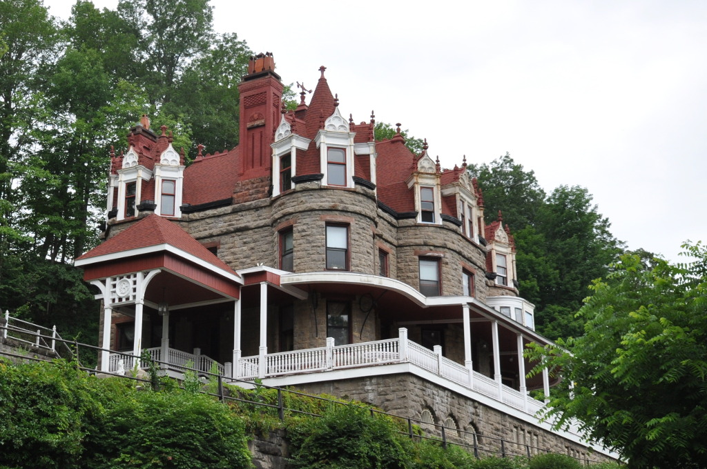
Overlook
Monument and historic site · National Register of Historic Places · 0.4 mi
Historic house in Little Falls, New York, United States

South Ann Street-Mill Street Historic District
Monument and historic site · National Register of Historic Places
Historic district in New York, United States
United States Post Office
Monument and historic site · National Register of Historic Places
Government building in Little Falls, New York


Herkimer Home State Historic Site
Monument and historic site · National Register of Historic Places · 2.4 mi

3 more on the map.
Parks, trails and playgrounds8


Restaurants and cafes1

Where to stay1

History
Little Falls was first settled by Europeans around 1723, when German Palatines were granted land under the Burnetsfield Patent. It was then the westernmost European settlement in the colony of New York. The need to portage around the falls promoted a trading location on the site of the future city. It was the first settlement in the town. The settlers were attacked during the French and Indian War, but rebuilt their farms.
The small settlement here was destroyed by Iroquois Indians, mostly Mohawk, and Tories in June 1782. The village was not resettled until 1790, and it was known at times as "Rockton" and "Rock City." Little Falls was incorporated as a village in 1811, and reincorporated in 1827. The City of Little Falls was chartered in 1895.
The Western Inland Canal (early attempt of the Erie Canal) was constructed in 1792 and helped the local economy. The Erie Canal, completed in 1825, passes through the city. Lock 17 of the New York State Erie Canal replaced the three locks of the original 1825 Erie Canal and is 40.5 feet (12.3 m) in height.
From the History section of Little Falls, New York on Wikipedia, under CC BY-SA 4.0.
Churches and places of worship13
Emmanuel Episcopal Church
Church · National Register of Historic Places
Saint Mary Catholic Church
Church · Roman Catholic
763 East Main Street, Little Falls
Shopping2
Gas and EV charging1
Schools, colleges and libraries11
James A Green Junior-Senior High School
School · 5.7 mi
38 Slawson St, Dolgeville
Little Falls Middle School/High School
School · 1.2 mi
251 High School Road, Little Falls
Mohawk Valley Christian Academy
School · 0.6 mi
144 West Monroe Street, Little Falls
Healthcare2
Map of Little Falls
54 places. The map loads OpenStreetMap tiles when you open it.
Climate by month
Monthly table
| Month | High | Low | Rain |
|---|---|---|---|
| Jan | 30°F | 11°F | 3.7 in |
| Feb | 32°F | 12°F | 3.7 in |
| Mar | 40°F | 20°F | 3.7 in |
| Apr | 54°F | 32°F | 4.2 in |
| May | 68°F | 44°F | 4.6 in |
| Jun | 76°F | 54°F | 4.8 in |
| Jul | 81°F | 58°F | 5.0 in |
| Aug | 79°F | 56°F | 4.5 in |
| Sep | 73°F | 48°F | 4.2 in |
| Oct | 59°F | 38°F | 5.0 in |
| Nov | 47°F | 28°F | 4.1 in |
| Dec | 35°F | 18°F | 4.6 in |
U.S. Climate Normals 1991-2020 for Little Falls City Rsch Hcn (1 mi away), rain and snow from Dolgeville 1.9 Nw, NOAA NCEI.
People and cost of living
American Community Survey 5-year estimates, 2020-2024, U.S. Census Bureau. Estimates have margins of error, larger for small towns.
Disaster history
Herkimer County has had 20 federal disaster declarations since 2000, most often for severe storms.
- 2020-03-20: Covid-19 Pandemic (Biological)
- 2020-03-13: Covid-19 (Biological)
- 2019-12-19: Severe Storms, Straight-Line Winds, And Flooding (Severe Storm)
- 2017-07-12: Severe Winter Storm And Snowstorm (Snowstorm)
- 2014-07-08: Severe Storms And Flooding (Severe Storm)
- 2013-07-12: Severe Storms And Flooding (Flood)
OpenFEMA disaster declarations summaries.
Getting there and nearby towns
Dolgeville Airport (1F6) is the nearest airport with scheduled flights listed in OpenStreetMap, 7 miles away.
- Dolgeville 6 mi northeast, about 9 min by car
- Herkimer 7 mi west, about 11 min by car
- Ilion 10 mi west, about 15 min by car
- St. Johnsville 10 mi east, about 15 min by car
- Frankfort 11 mi west, about 17 min by car
- Fort Plain 14 mi southeast, about 22 min by car
- Richfield Springs 15 mi southwest, about 24 min by car
- Canajoharie 18 mi southeast, about 29 min by car
- Utica 19 mi west, about 31 min by car
- New Hartford 22 mi west, about 35 min by car
Drive times are estimates from straight-line distance, not routes.
Local news
Headlines from INDB, the NEMICO news database.
Reviews, tips and questions
Loading what members have shared...
Sources and licences
- NCES EDGE (Public domain): public schools
- NOAA NCEI U.S. Climate Normals 1991-2020 (Public domain): climate by month
- OpenFEMA (Public domain): disaster declarations
- OpenStreetMap contributors (ODbL 1.0): places, airports, map data
- U.S. Census Bureau (Public domain): population, income, housing, education, commute
- Wikidata (CC0 1.0): elevation, founding date, time zone, website, landmarks and historic places
- Wikimedia Commons (see each image): photos
- Wikipedia (CC BY-SA 4.0): overview and history text
Photo credits
- City Hall, Little Falls, NY, Arjharris, CC BY-SA 3.0
- Emmanuel Episcopal Church Jun 09, Doug Kerr from Upstate New York, CC BY-SA 2.0
- LittleFallsNY OverlookMansion, Magicpiano, CC BY-SA 4.0
- LittleFallsNY PostOffice, Magicpiano, CC BY-SA 4.0
- James Sanders House Jun 09, Doug Kerr from Upstate New York, CC BY-SA 2.0
- Italian Community Bake Oven - Exterior angle, Apocheir, CC BY-SA 4.0
- LittleFallsNY SouthAnnMillStreetHD 3, Magicpiano, CC BY-SA 4.0
- St. Mary's Catholic Church Little Falls NY Jun 09, Doug Kerr from Albany, NY, United States, CC BY-SA 2.0
- LittleFallsNY HerkimerTrustCompanyBuilding, Magicpiano, CC BY-SA 4.0
- Herkimer House 2009, Wknight94 talk, CC BY-SA 3.0
Page built October 30, 2026. Spotted a mistake? Tell us or suggest a place.