


Millville, Utah
Millville is a city of 1,800 people in Cache County, Utah, founded in 1860.
Why visit Millville
Townapedia lists 11 museums and landmarks, 16 parks and trails, 4 places to eat, 1 place to stay and 1 attraction in and around town.
Highlights include Ellen Eccles Theatre, David Eccles House and Erick Lehi and Ingrid Larsen Olson House.
July is the warmest month, with average highs of 88°F; January lows average 12°F, and about 52 inches of snow fall in a normal year.
Weather in Millville
Forecast from the National Weather Service. Full forecast
About Millville
Millville is a city in Cache County, Utah, United States. The population was 2,222 at the 2020 census, with an estimated population of 2,300 in 2022. It is included in the Logan, Utah-Idaho Metropolitan Statistical Area.
From the Wikipedia article Millville, Utah (this version), under CC BY-SA 4.0.
Things to do1
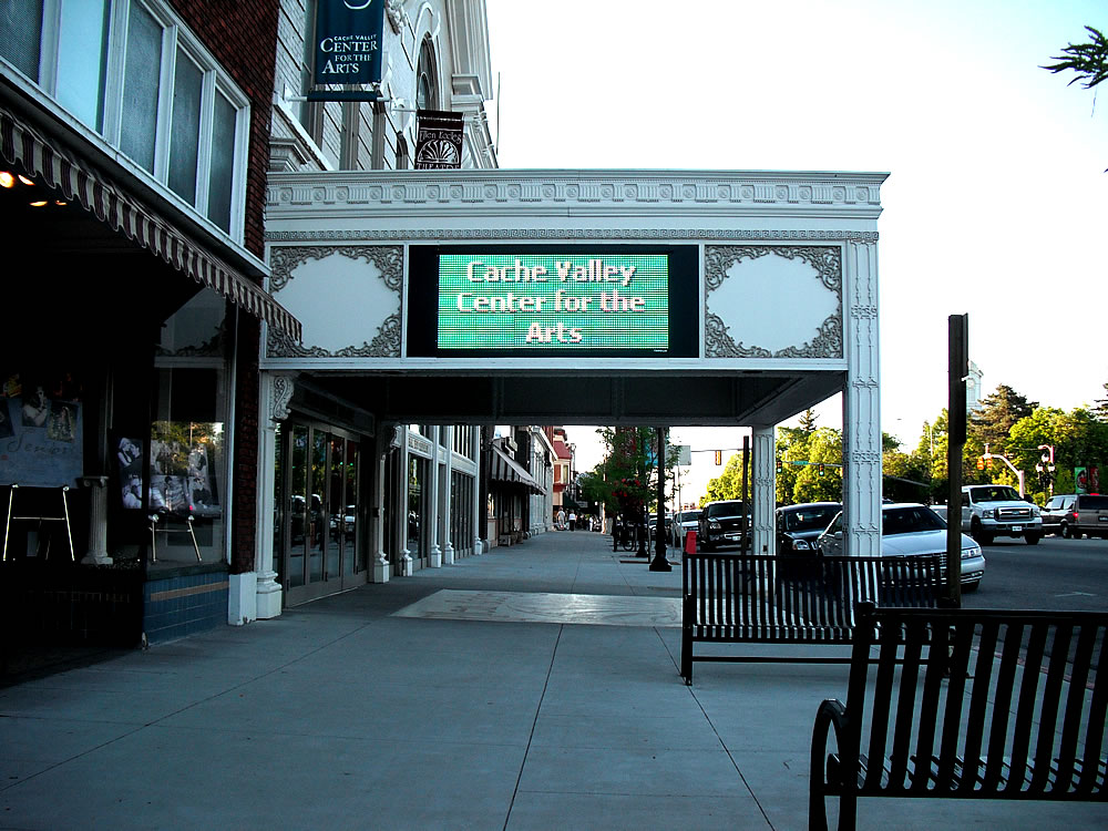
Ellen Eccles Theatre
Cinema and theater · 3.2 mi
Theater and former movie theater in Logan, Utah, United States
Museums and landmarks11

David Eccles House
Monument and historic site · National Register of Historic Places · 3.3 mi
Single-family detached home in Logan, United States of America

Erick Lehi and Ingrid Larsen Olson House
Monument and historic site · National Register of Historic Places · 2.5 mi
Historic house in River Heights, Utah

Logan High School Gymnasium
Monument and historic site · National Register of Historic Places · 3.1 mi
Gymnasium in Logan, Utah

Logan Utah Temple
Monument and historic site · National Register of Historic Places · 3.4 mi
Temple of The Church of Jesus Christ of Latter-day Saints in Logan, Utah, United States

Providence LDS Chapel and Meetinghouse
Monument and historic site · National Register of Historic Places · 1.6 mi
Historic building in Providence, Utah, United States
River Heights Sinclair Station
Monument and historic site · National Register of Historic Places · 2.5 mi
Gas station in River Heights, Utah

Whittier School
Monument and historic site · National Register of Historic Places · 3.6 mi
School building in Logan, United States of America

Crockett House
Monument and historic site · National Register of Historic Places · 3.4 mi


Logan Temple Barn
Monument and historic site · National Register of Historic Places · 3.5 mi

Parks, trails and playgrounds16

4 more on the map.
Restaurants and cafes4


Panda Express
Fast food · Chinese · 1.8 mi
16 North Highway 165, Providence
Mo-Th 09:30-22:00; Fr 09:30-22:30; Sa 10:00-22:30; Su 10:30-21:00
History
George White Pitkin built the first log home in Millville, before the settlement was organized or named. He and his sons, Ammon Paul Pitkin and George Orrin Pitkin, built the home in 1859. The family moved into it in late spring 1860. The present location of the home is 136 W. 100 South, in Millville. It became the Pitkin homestead. Church and school were held there. As George White Pitkin was an educated man, he taught until a "proper" church and school were built. Later, the Pitkin family built a two-story rock home with walls 2 feet (0.61 m) thick. George died at the age of 72 on November 26, 1873, and is buried in the Millville cemetery.
From the History section of Millville, Utah on Wikipedia, under CC BY-SA 4.0.
Where to stay1
Churches and places of worship11
Logan LDS Sixth Ward Church
Church · National Register of Historic Places · 2.8 mi
Logan Tabernacle
Church · National Register of Historic Places · 3.3 mi
The Church of Jesus Christ of Latter-day Saints
Church · Mormon · 0.9 mi
262 Canyon Road, Providence
The Church of Jesus Christ of Latter-day Saints
Church · Mormon · 1.5 mi
180 South 485 West, Providence
The Church of Jesus Christ of Latter-day Saints
Church · Mormon · 1.2 mi
309 South Main Street, Providence
The Church of Jesus Christ of Latter-day Saints
Church · Mormon · 1.8 mi
155 North 100 East, Providence
The Church of Jesus Christ of Latter-day Saints
Church · Latter-Day Saints · 0.8 mi
Shopping1
Gas and EV charging2
Schools, colleges and libraries31
Healthcare2
South Cache Valley Clinic
Clinic and pharmacy · 1.5 mi
190 South Highway 165, Providence
Map of Millville
80 places. The map loads OpenStreetMap tiles when you open it.
Climate by month
Monthly table
| Month | High | Low | Rain | Snow |
|---|---|---|---|---|
| Jan | 32°F | 12°F | 1.9 in | 12.5 in |
| Feb | 37°F | 16°F | 1.5 in | 11.7 in |
| Mar | 48°F | 27°F | 1.9 in | 5.9 in |
| Apr | 57°F | 34°F | 2.0 in | 2.5 in |
| May | 67°F | 41°F | 2.2 in | 0.1 in |
| Jun | 78°F | 48°F | 1.1 in | 0.0 in |
| Jul | 88°F | 54°F | 0.6 in | 0.0 in |
| Aug | 86°F | 53°F | 0.7 in | 0.0 in |
| Sep | 76°F | 43°F | 1.2 in | 0.0 in |
| Oct | 62°F | 32°F | 1.7 in | 1.0 in |
| Nov | 46°F | 24°F | 1.4 in | 4.7 in |
| Dec | 33°F | 14°F | 1.7 in | 13.2 in |
U.S. Climate Normals 1991-2020 for Logan 5 Sw Exp Farm (4 mi away), NOAA NCEI.
People and cost of living
American Community Survey 5-year estimates, 2020-2024, U.S. Census Bureau. Estimates have margins of error, larger for small towns.
Disaster history
Cache County has had 5 federal disaster declarations since 2000, most often for biologicals.
- 2020-04-04: Covid-19 Pandemic (Biological)
- 2020-03-13: Covid-19 (Biological)
- 2017-04-21: Severe Winter Storms And Flooding (Flood)
- 2011-08-08: Flooding (Flood)
- 2005-09-05: Hurricane Katrina Evacuation (Coastal Storm)
OpenFEMA disaster declarations summaries.
Getting there and nearby towns
Logan-Cache Airport (LGU) is the nearest airport with scheduled flights listed in OpenStreetMap, 7 miles away.
- Logan 4 mi north, about 6 min by car
- Hyrum 4 mi south, about 6 min by car
- North Logan 6 mi north, about 10 min by car
- Benson 7 mi northwest, about 12 min by car
- Hyde Park 8 mi north, about 13 min by car
- Mendon 8 mi west, about 13 min by car
- Smithfield 10 mi north, about 17 min by car
- Mantua 13 mi southwest, about 21 min by car
- Elwood 16 mi west, about 26 min by car
- Brigham City 17 mi southwest, about 28 min by car
Drive times are estimates from straight-line distance, not routes.
Local news
Headlines from INDB, the NEMICO news database.
Reviews, tips and questions
Loading what members have shared...
Sources and licences
- NCES EDGE (Public domain): public schools
- NOAA NCEI U.S. Climate Normals 1991-2020 (Public domain): climate by month
- OpenFEMA (Public domain): disaster declarations
- OpenStreetMap contributors (ODbL 1.0): places, airports, map data
- U.S. Census Bureau (Public domain): population, income, housing, education, commute
- Wikidata (CC0 1.0): elevation, founding date, time zone, website, landmarks and historic places
- Wikimedia Commons (see each image): photos
- Wikipedia (CC BY-SA 4.0): overview and history text
Photo credits
- Logan Utah Temple, Cory Maylett, CC BY-SA 3.0
- Whittier School Logan Utah, Tricia Simpson, CC BY-SA 3.0
- Logan Tabernacle (Logan, UT), Cornellrockey, CC BY-SA 2.5
- Old Rock Church Providence Utah, Tricia Simpson, CC BY-SA 3.0
- Eccles House Logan Utah, Ntsimp, CC0
- Sixth Ward Church Logan Utah, Tricia Simpson, CC BY-SA 3.0
- Olson House River Heights Utah, Ntsimp, CC0
- Logan Temple Barn, Louise T. Taft, Photographer, Public domain
- Crockett House Logan Utah, Tricia Simpson, CC BY-SA 3.0
- Ellen eccles theater, UtahStizzle, Public domain
- Forb Seed increase plot photo 1 (29528298653), Intermountain Forest Service, USDA Region 4 Photography, Public domain
- Bartschi Blacksmith Shop Providence Utah, Ntsimp, CC0
- Backlit by snow (Unsplash), Greg Rakozy grakozy, CC0
- STS122-E-11327 - View of Earth, NASA, Public domain
- STS122-E-11328 - View of Earth, NASA, Public domain
- ISS059-E-96082 - View of Wisconsin, Earth Science and Remote Sensing Unit, NASA Johnson Space Center, Public domain
- ISS047-E-96735 - View of Earth, Earth Science and Remote Sensing Unit , Lyndon B. Johnson Space Center, Public domain


Page built October 30, 2026. Spotted a mistake? Tell us or suggest a place.