


Montclair, Virginia
Montclair is a community of 22,387 people in Prince William County, Virginia.
Why visit Montclair
Townapedia lists 14 museums and landmarks, 11 parks and trails, 56 places to eat and 9 places to stay in and around town.
Highlights include Bel Air, Cabin Branch Pyrite Mine Historic District and Cloverdale Park.
July is the warmest month, with average highs of 88°F; January lows average 28°F.
Weather in Montclair
Forecast from the National Weather Service. Full forecast
About Montclair
Montclair is a census-designated place (CDP) in Prince William County, Virginia, United States. The population was 22,279 in the 2020 census. An affluent residential community surrounding a man-made lake and golf course, development began in the late 1960s and new home construction ended during the 1990s.
From the Wikipedia article Montclair, Virginia (this version), under CC BY-SA 4.0.
Museums and landmarks14

Bel Air
Monument and historic site · National Register of Historic Places · 2.1 mi
Colonial-era plantation manor in Virginia, United States

Cabin Branch Pyrite Mine Historic District
Monument and historic site · National Register of Historic Places · 2.6 mi
Historic district in Virginia, United States
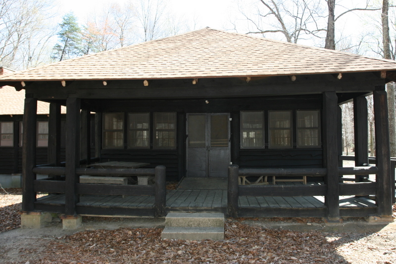
Chopawamsic Recreational Demonstration Area Cabin Camp 1
Monument and historic site · National Register of Historic Places · 1.4 mi
Civilian Conservation Corps campsite

Old Hotel
Monument and historic site · National Register of Historic Places · 3.3 mi
Hotel in Dumfries, Virginia
Orenda/SP-26 Historic District, Chopawamsic RDA Camp 3
Monument and historic site · National Register of Historic Places · 3.6 mi
Recreational demonstration camp
Pleasant Historic District, Chopawamsic RDA Camp 4
Monument and historic site · National Register of Historic Places · 1.7 mi
Historic district in Virginia, United States

Rippon Lodge
Monument and historic site · National Register of Historic Places · 3.5 mi
Human settlement in Virginia, United States of America

Weems–Botts Museum
Museum · National Register of Historic Places · 3.2 mi
Building in Virginia, United States


Old Town Hall and School
Monument and historic site · National Register of Historic Places · 3.3 mi
2 more on the map.
Parks, trails and playgrounds11




Restaurants and cafes56

Armetta's Italian Grill & Pizzeria
Restaurant · Italian · 2.1 mi
5524 Staples Mill Plaza, Woodbridge
Mo-Th 11:00-22:00; Fr, Sa 11:00-23:00; Su 12:00-22:00



44 more on the map.
Where to stay9


Candlewood Suites Dumfries - Quantico
Motel and hotel · 2.2 mi
16927 Old Stage Road, Dumfries
Churches and places of worship21
Dale City Baptist Church
Church · Baptist · 1.7 mi
3501 Dale Boulevard, Woodbridge
Evangelical Baptist Church
Church · Baptist · 2.2 mi
14836 Ashdale Avenue, Woodbridge
First Mount Zion Baptist Church
Church · Baptist · 1.7 mi
16622 Dumfries Road, Dumfries
First United Presbyterian church
Church · Presbyterian · 1.6 mi
14391 Minnieville Road, Woodbridge
Freedom Fellowship Church
Church · Nondenominational · 2.3 mi
4320 Dale Boulevard, Woodbridge
Good Shepheard United Methodist Church
Church · United Methodist · 1.9 mi
14999 Dale Boulevard, Dale City
Greenwood Primitive Baptist church
Church · Baptist · 1.6 mi
Cardinal Drive, Woodbridge
Little Union Baptist Church
Church · Baptist · 2.4 mi
17150 Batestown Road, Dumfries
Luthern Church of the Covenant
Church · Lutheran · 1.4 mi
15008 Cloverdale Road, Woodbridge
Montclair Tabernacle
Church · Church Of God · 0.9 mi
16120 Dumfries Road, Dumfries
Neabsco Baptist Church
Church · Baptist · 1.4 mi
15557 Cardinal Drive, Woodbridge
Shopping7
Gas and EV charging9
Schools, colleges and libraries56
Healthcare4
Dalewood Medical Clinic
Clinic and pharmacy · 2.1 mi
4158 Dale Boulevard, Woodbridge
Map of Montclair
187 places. The map loads OpenStreetMap tiles when you open it.
Climate by month
Monthly table
| Month | High | Low | Rain | Snow |
|---|---|---|---|---|
| Jan | 45°F | 28°F | 2.7 in | 3.5 in |
| Feb | 48°F | 30°F | 2.4 in | 5.8 in |
| Mar | 56°F | 37°F | 3.6 in | 1.4 in |
| Apr | 68°F | 47°F | 3.2 in | 0.0 in |
| May | 76°F | 57°F | 3.6 in | 0.0 in |
| Jun | 84°F | 66°F | 3.5 in | 0.0 in |
| Jul | 88°F | 71°F | 4.6 in | 0.0 in |
| Aug | 86°F | 69°F | 4.2 in | 0.0 in |
| Sep | 80°F | 62°F | 3.4 in | 0.0 in |
| Oct | 69°F | 50°F | 3.3 in | 0.0 in |
| Nov | 58°F | 39°F | 3.1 in | 0.0 in |
| Dec | 49°F | 32°F | 3.3 in | 1.7 in |
U.S. Climate Normals 1991-2020 for Quantico Mcas (8 mi away), NOAA NCEI.
People and cost of living
American Community Survey 5-year estimates, 2020-2024, U.S. Census Bureau. Estimates have margins of error, larger for small towns.
Disaster history
Prince William County has had 14 federal disaster declarations since 2000, most often for hurricanes.
- 2026-01-23: Severe Winter Storm (Winter Storm)
- 2020-04-02: Covid-19 Pandemic (Biological)
- 2020-03-13: Covid-19 (Biological)
- 2018-09-11: Hurricane Florence (Hurricane)
- 2016-03-07: Severe Winter Storm And Snowstorm (Snowstorm)
- 2012-11-26: Hurricane Sandy (Hurricane)
OpenFEMA disaster declarations summaries.
Getting there and nearby towns
Quantico Marine Corps Airfield/Turner Field (NYG) is the nearest airport with scheduled flights listed in OpenStreetMap, 8 miles away.
- Dale City 2 mi north, about 4 min by car
- Leesylvania 3 mi east, about 5 min by car
- Cherry Hill 4 mi southeast, about 7 min by car
- Independent Hill 5 mi northwest, about 8 min by car
- Lake Ridge 5 mi north, about 9 min by car
- Lorton 9 mi northeast, about 14 min by car
- Buckhall 9 mi northwest, about 14 min by car
- Manassas 12 mi northwest, about 19 min by car
- Burke 12 mi north, about 19 min by car
- Manassas Park 12 mi northwest, about 19 min by car
Drive times are estimates from straight-line distance, not routes.
Local news
Headlines from INDB, the NEMICO news database.
Reviews, tips and questions
Loading what members have shared...
Sources and licences
- NCES EDGE (Public domain): public schools
- NOAA NCEI U.S. Climate Normals 1991-2020 (Public domain): climate by month
- OpenFEMA (Public domain): disaster declarations
- OpenStreetMap contributors (ODbL 1.0): places, airports, map data
- U.S. Census Bureau (Public domain): population, income, housing, education, commute
- Wikidata (CC0 1.0): elevation, founding date, time zone, website, landmarks and historic places
- Wikimedia Commons (see each image): photos
- Wikipedia (CC BY-SA 4.0): overview and history text
Photo credits
- I-95 NB at HOT lanes entrance Montclair VA, Dough4872, CC BY-SA 3.0
- 2019-06-24 13 44 36 View south along Interstate 95 from the overpass for Virginia State Route 610 (Cardinal Drive) on the edge of Montclair and Neabsco in Prince William County, Virginia, Famartin, CC BY-SA 4.0
- 2019-10-18 13 10 41 View south along Virginia State Route 234 (Dumfries Road) at the exit for Interstate 95 SOUTH (Richmond) in Montclair, Prince William County, Virginia, Famartin, CC BY-SA 4.0
- 2019-05-29 11 55 05 View south along Interstate 95 at Exit 152B (Virginia State Route 234 NORTH, Manassas) on the edge of Montclair and Cherry Hill in Prince William County, Virginia, Famartin, CC BY-SA 4.0
- Chopawamsic Camp 4 dining VA NPS, National Park Service, Public domain
- Rippon Lodge Today, WhiteKMJK, Public domain
- Chopawamsic Camp 1 VA NPS, National Park Service, Public domain
- Weems-Botts House (Dumfries, Virginia) 001, Leonard J. DeFrancisci, CC BY-SA 3.0
- AACA concentrate bin ruins VA NPS, National Park Service, Public domain
- OLD HOTEL; PRINCE WILLIAM COUNTY, Jerrye & Roy Klotz, MD, CC BY-SA 3.0
- OLD TOWN HALL AND SCHOOL, PRINCE WILLIAM COUNTY, VA, Jerrye & Roy Klotz, MD, CC BY-SA 3.0
- Forest Park Senior High School, Northern-Virginia-Photographer, CC0
- Forest Park High School football (Woodbridge, Virginia), Muted Sunset, Northern-Virginia-Photographer, CC BY-SA 4.0
- Prince William Forest Park - January Walk - Pretty Creek (12021266824), Mrs. Gemstone from USA, CC BY-SA 2.0
- North Fork Quantico Creek and North Valley Trail - panoramio, Fredlyfish4, CC BY-SA 4.0
- Beaver in North Fork Quantico Creek - panoramio, Fredlyfish4, CC BY-SA 4.0
- Prince William Forest Park - January Walk - Pretty creek, Mrs. Gemstone from USA, CC BY-SA 2.0
- Beaver Dam on North Fork Quantico Creek - panoramio, Fredlyfish4, CC BY-SA 4.0
- Prince William Forest Park - January Walk - Panorama (12020910705), Mrs. Gemstone from USA, CC BY-SA 2.0
- On our way to North Carolinaeiou (7030771773), Antonio Zugaldia from Washington, D.C., United States, CC BY 2.0
- Quantico Falls PRWI, Ken, CC BY 2.0
- Prince William Forest Park - January Walk (12021728676), Mrs. Gemstone from USA, CC BY-SA 2.0
- Muzaffar Aazim, FinalImpact2, CC BY-SA 4.0
- Prince William Forest Park - January Walk (12021739366), Mrs. Gemstone from USA, CC BY-SA 2.0
- Prince William Forest Park - January Walk (12020891715), Mrs. Gemstone from USA, CC BY-SA 2.0
- Prince William Forest Park - January Walk - Miniature (12021181603), Mrs. Gemstone from USA, CC BY-SA 2.0
- Prince William Forest Park - January Walk - Sundog & Setting Sun (12020915935), Mrs. Gemstone from USA, CC BY-SA 2.0
- Virginia 2 - panoramio, On^ste82, CC BY 3.0
- Prince William Forest Park - January Walk (12021725876), Mrs. Gemstone from USA, CC BY-SA 2.0
- Virginia Woods - panoramio, On^ste82, CC BY 3.0
- Prince William Forest Park - January Walk - Tree (12020899025), Mrs. Gemstone from USA, CC BY-SA 2.0
- North Fork Quantico Creek Prince William Forest Park, Fredlyfish4, CC BY-SA 4.0
- 2019-06-24 13 46 28 View north along Interstate 95 from the overpass for Virginia State Route 610 (Cardinal Drive) on the edge of Dale City and Neabsco in Prince William County, Virginia, Famartin, CC BY-SA 4.0
- Venetian balusters stair transformation (29970868700), The Finishing Company Richmond Va from Richmond,Virginia, United States, CC BY 2.0
- Bel air East side, Cb350, CC BY-SA 3.0
- Alden Lake Hoist, This photo was taken by a private person in 1906 and never published., Public domain
- North Fork Quantico Creek - panoramio, Fredlyfish4, CC BY-SA 4.0
- USA - Virginia - Prince William Forest Park - 51983321055, Alexander Hatley, CC BY 2.0
- USA - Virginia - Prince William Forest Park - 51982771306, Alexander Hatley, CC BY 2.0
- 2012-366-51 Snow Lace (6913999851), cogdogblog, CC BY 2.0


Page built October 30, 2026. Spotted a mistake? Tell us or suggest a place.