


Why visit Moodus
Townapedia lists 9 museums and landmarks, 21 parks and trails, 3 places to eat, 2 places to stay and 3 attractions in and around town.
Highlights include Comstock's Bridge, East Haddam Bridge, Amasa Day House and East Haddam Historic District.
Weather in Moodus
Forecast from the National Weather Service. Full forecast
About Moodus
Moodus is a village in the town of East Haddam, Connecticut, United States. The village is the basis of a census-designated place (CDP) of the same name. The population of the CDP was 1,982 as of the census of 2020.
From the Wikipedia article Moodus, Connecticut (this version), under CC BY-SA 4.0.
Things to do3

Comstock's Bridge
Bridge · National Register of Historic Places · 3.6 mi

East Haddam Bridge
Bridge · 3.8 mi
Bridge in United States of America

Museums and landmarks9

Amasa Day House
Monument and historic site · National Register of Historic Places · 0.9 mi
Historic house in Connecticut, United States

East Haddam Historic District
Monument and historic site · National Register of Historic Places · 3.4 mi
Historic district in Connecticut, United States

Goodspeed Musicals
Cinema and theater · National Register of Historic Places · 3.7 mi
Theatre in East Haddam, Connecticut, United States
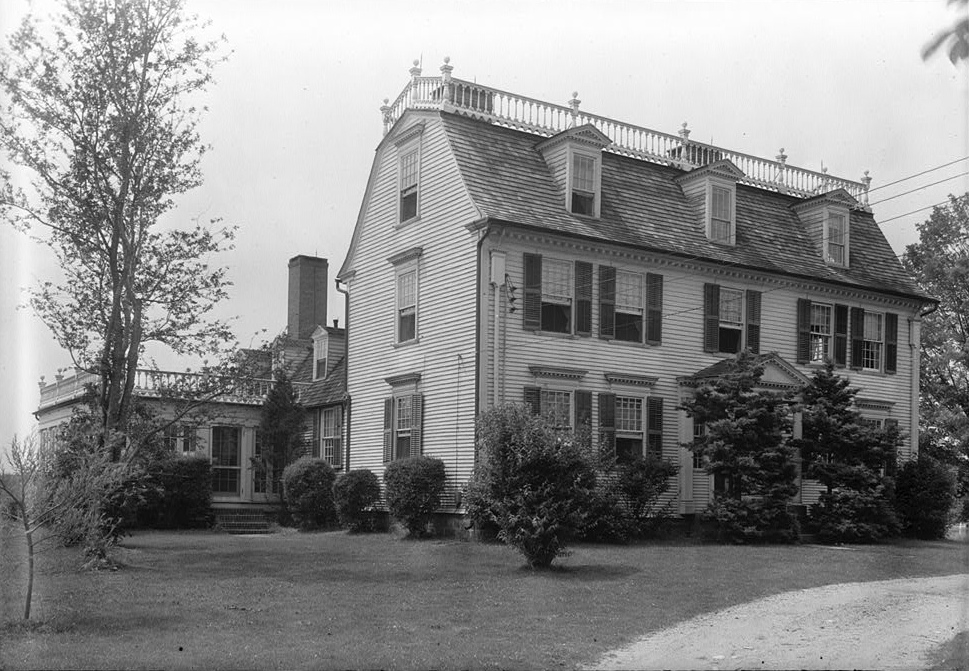
Henry Champion House
Monument and historic site · National Register of Historic Places · 3.1 mi
Historic house in Connecticut, United States

Little Haddam Historic District
Monument and historic site · National Register of Historic Places · 1.7 mi
Human settlement in Connecticut, United States of America

Warner House
Monument and historic site · National Register of Historic Places · 3.4 mi
United States national historic place


Wickham Road Historic District
Monument and historic site · National Register of Historic Places · 2.9 mi
Historic district in Connecticut, United States
Emery Johnson Homestead
Monument and historic site · 1.7 mi
59 Johnsonville Road, East Haddam
Parks, trails and playgrounds21



Town Open Space (Route 149)
Hiking and trails · 0.8 mi
Municipal, Open To Public Without Fee
9 more on the map.
Restaurants and cafes3


History
Prior to its purchase by English settlers in 1662, the area around Moodus was inhabited by Native American Algonquians. The names of three of the inhabiting tribes are known: the Wangunks, the Mohegans and the Nehantics. The name was derived from the Native American name for the area. The name was "Matchetmadosett" or "Matchitmoodus". It can be translated to the place of noises. Its name possibly because of the frequent earthquakes in the area. Numerous earthquakes were recorded in the area between 1638 and 1899. Loud rumblings, possibly the "Moodus Noises", could be heard for miles surrounding the epicenter of the quakes near Mt. Tom. The land, which is now the towns of Haddam and East Haddam, was purchased by settlers from the Indians in 1662 for thirty coats. In today's money, it is worth about $100.
From the History section of Moodus, Connecticut on Wikipedia, under CC BY-SA 4.0.
Where to stay2
Churches and places of worship4
Saint Bridget of Kildare (The Saint John Paul II Parish) Catholic Church
Church · Roman Catholic · 1.4 mi
75 Moodus Leesville Road, Moodus
Shopping1
Gas and EV charging1
Schools, colleges and libraries5
Healthcare1
Map of Moodus
50 places. The map loads OpenStreetMap tiles when you open it.
People and cost of living
American Community Survey 5-year estimates, 2020-2024, U.S. Census Bureau. Estimates have margins of error, larger for small towns.
Disaster history
The county has had 20 federal disaster declarations since 2000, most often for hurricanes.
- 2021-10-30: Remnants Of Hurricane Ida (Hurricane)
- 2021-08-22: Hurricane Henri (Hurricane)
- 2021-01-12: Tropical Storm Isaias (Hurricane)
- 2020-08-06: Tropical Storm Isaias (Hurricane)
- 2020-03-28: Covid-19 Pandemic (Biological)
- 2020-03-13: Covid-19 (Biological)
OpenFEMA disaster declarations summaries.
Getting there and nearby towns
Hartford–Brainard Airport (HFD) is the nearest airport with scheduled flights listed in OpenStreetMap, 20 miles away.
- East Hampton 6 mi northwest, about 9 min by car
- Higganum 6 mi west, about 10 min by car
- Lake Pocotopaug 7 mi northwest, about 12 min by car
- Chester Center 7 mi south, about 11 min by car
- Colchester 7 mi northeast, about 12 min by car
- Deep River Center 9 mi south, about 14 min by car
- Essex Village 10 mi south, about 17 min by car
- Middletown 12 mi west, about 19 min by car
- Durham 13 mi west, about 21 min by car
- Glastonbury Center 16 mi northwest, about 26 min by car
Drive times are estimates from straight-line distance, not routes.
Local news
Headlines from INDB, the NEMICO news database.
Reviews, tips and questions
Loading what members have shared...
Sources and licences
- NCES EDGE (Public domain): public schools
- OpenFEMA (Public domain): disaster declarations
- OpenStreetMap contributors (ODbL 1.0): places, airports, map data
- U.S. Census Bureau (Public domain): population, income, housing, education, commute
- Wikidata (CC0 1.0): elevation, founding date, time zone, website, landmarks and historic places
- Wikimedia Commons (see each image): photos
- Wikipedia (CC BY-SA 4.0): overview and history text
Photo credits
- Moodus United Methodist Church, Moodus CT, John Phelan, CC BY-SA 4.0
- East Haddam Free Public Library, Moodus CT, John Phelan, CC BY 4.0
- Gettysburg Soldier Memorial, Moodus CT, John Phelan, CC BY 4.0
- Amasa Day House, Moodus CT, John Phelan, CC BY 4.0
- Moodus, CT, CTsignhunt, CC0
- Moodus Reservoir Dam, East Haddam CT, John Phelan, CC BY 4.0
- WICKHAM ROAD HISTORIC DISTRICT, EAST HADDAM, MIDDLESEX COUNTY, CT, JERRYE & ROY KLOTZ, M.D., CC BY-SA 4.0
- GoodspeedOperaHouse, Arnold33 at English Wikipedia, Public domain
- Henry Champion House, Historic American Buildings Survey, creator, Public domain
- AmasaDayHouseMoodusCT, Jerry Dougherty, CC BY 2.5
- NathanHaleSchoolEastHaddamCT, Jerry Dougherty, CC BY 2.5
- Warner House, WPA Architectural Survey, WPA Architectural Survey, Public domain
- BBHTSalmonRiverComstockBridge2, H. Morrow Long, CC BY-SA 3.0
- IMG 4064 East Haddam bridge, Denimadept, CC BY-SA 3.0
- 2021 Ford Bronco Wildtrak 4-door soft-top front close-up, Nathan Dimartino, CC BY-SA 4.0
- Amasa Day House, CTLandmarks, CC BY-SA 4.0
- Preserved Phone Booth At East Haddam Municipal Offices September 2021, Nathan Dimartino, CC BY-SA 4.0
- EastHaddamCT AmasaDayHouse, Magicpiano, CC BY-SA 3.0
- Johnsonville Covered Bridge, Johnsonville Village CT, John Phelan, CC BY 4.0
- Chapel, Johnsonville CT, John Phelan, CC BY 4.0
- Resting place of Venture Smith, NoraInMoodus, CC BY-SA 4.0
- Johnsonville Road, Johnsonville CT, John Phelan, CC BY 4.0
- Schoolhouse, Johnsonville CT, John Phelan, CC BY 4.0
- Emory Johnson Homestead, Johnsonville CT, John Phelan, CC BY 4.0
- Johnson Milldam, Johnsonville CT, John Phelan, CC BY 4.0
- ISS067-E-141166 - View of Earth, Earth Science and Remote Sensing Unit , Lyndon B. Johnson Space Center, Public domain
- ISS026-E-16359 - View of Earth, Earth Science and Remote Sensing Unit , Lyndon B. Johnson Space Center, Public domain
- ISS050-E-20959 - View of Earth, Earth Science and Remote Sensing Unit , Lyndon B. Johnson Space Center, Public domain
- ISS011-E-6216 - View of New York, Earth Science and Remote Sensing Unit , Lyndon B. Johnson Space Center, Public domain
- CT Route 149, East Haddam CT, John Phelan, CC BY 4.0


Page built October 30, 2026. Spotted a mistake? Tell us or suggest a place.