




Why visit Mount Pleasant
Townapedia lists 26 museums and landmarks, 11 parks and trails, 24 places to eat, 4 places to stay and 2 attractions in and around town.
Highlights include Oakland Mills Bridge, Main Street Cinemas, Mount Pleasant City Hall and Brazelton House.
July is the warmest month, with average highs of 85°F; January lows average 12°F, and about 25 inches of snow fall in a normal year.
Weather in Mount Pleasant
Forecast from the National Weather Service. Full forecast
About Mount Pleasant
Mount Pleasant is a city in and the county seat of Henry County in the U.S. state of Iowa. The population was 9,274 in the 2020 census, an increase from 8,668 in the 2010 census. It was founded in 1835 by pioneer Presley Saunders.
From the Wikipedia article Mount Pleasant, Iowa (this version), under CC BY-SA 4.0.
Things to do2

Oakland Mills Bridge
Bridge · National Register of Historic Places · 4.1 mi
United States historic place

Museums and landmarks26

Mount Pleasant City Hall
Monument and historic site · National Register of Historic Places · 0.5 mi
Rathaus in Mount Pleasant, United States of America
Brazelton House
Monument and historic site · National Register of Historic Places · 0.6 mi
Historic house in Iowa, United States
Brazelton House Hotel
Monument and historic site · National Register of Historic Places · 0.4 mi
Hotel in Mount Pleasant, United States of America

Camp Harlan-Camp McKean Historic District
Monument and historic site · National Register of Historic Places · 2.0 mi
Nationally recognized historic district located northwest of Mount Pleasant, Iowa, United States

Dr. J.O. and Catherine Ball House
Monument and historic site · National Register of Historic Places · 0.7 mi
Historic house in Iowa, United States
First National Bank
Monument and historic site · National Register of Historic Places · 0.5 mi
Bank in Mount Pleasant, United States of America

Former Mount Pleasant Public Library
Monument and historic site · National Register of Historic Places · 0.5 mi
Public library in Mount Pleasant, United States of America
G. W. S. Allen House
Monument and historic site · National Register of Historic Places · 0.5 mi
United States historic place
George and Margaret Cooper House
Monument and historic site · National Register of Historic Places · 0.6 mi
Mount Pleasant, Iowa, listed on the NRHP in Iowa
Harlan House Hotel
Monument and historic site · National Register of Historic Places · 0.5 mi
Hotel building in Mount Pleasant, United States of America

Harlan-Lincoln House
Monument and historic site · National Register of Historic Places · 0.7 mi
Historic house in Iowa, United States


Henry Ambler House
Monument and historic site · National Register of Historic Places · 0.7 mi
United States historic place
14 more on the map.
Parks, trails and playgrounds11



Restaurants and cafes24

Sanity Coffee House
Cafe · Coffee Shop · 1.2 mi
104 South Iris Street, Mount Pleasant
Tu-Fr 05:00-14:00; Sa 06:00-14:00

The Grange Public House and Brewery
Restaurant · Burger, American, Asian, Steak House · 0.5 mi
129 South Jefferson Street, Mount Pleasant

Batter & Dough
Bakery · 0.4 mi
114 North Main Street, Mount Pleasant
Tu-Sa 06:30-14:00
12 more on the map.
History
The first permanent settlement at Mount Pleasant was made in 1833. Mount Pleasant was incorporated as a town in 1842, and again in 1851.
In 1869, Mount Pleasant was the site of a solar eclipse expedition, under the command of James Craig Watson and sponsored by National Almanac. The total solar eclipse occurred on August 7, 1869.
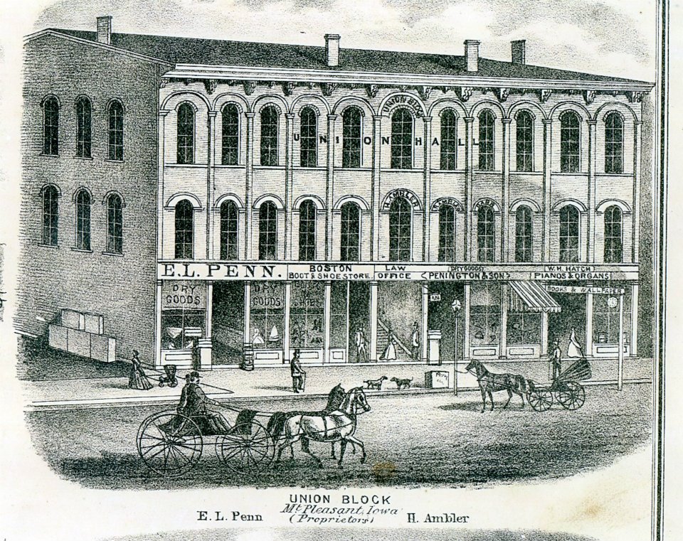
In the Union Block building in 1869, Arabella A. Mansfield became the first woman in the United States to be awarded a license to practice law. She had passed the bar exam with high scores and won a court case for entry to the bar. The legislature changed its statute.
The third floor of the Union Block housed the Opera House or Union Hall, a gathering place for the community. It attracted national speakers on tour, including abolitionists Frederick Douglass, Sojourner Truth, and Anna Dickinson. James Harlan also spoke there, as he was president of Iowa Wesleyan College in the town, and later was elected several times to the United States Senate. This building had been considered one of the most endangered historic sites in Iowa.
The Mount Pleasant Mental Health Institute was built in 1861. However, in 1936, a fire did great damage to the original building. Beginning in 1976, many of the hospital facilities were transferred to the Mount Pleasant Correctional Facility, which still occupies the campus. The hospital itself was closed in 2015.
From the History section of Mount Pleasant, Iowa on Wikipedia, under CC BY-SA 4.0.
Where to stay4
Churches and places of worship18
Second Baptist Church
Church · Baptist · National Register of Historic Places · 0.8 mi
Congregational Universalist Church
Church · Congregational
300 East Washington Street, Mount Pleasant
Saint Michael's Episcopal Church
Church · Episcopal
202 East Washington Street, Mount Pleasant
Shopping10
Gas and EV charging7
Schools, colleges and libraries13
Healthcare5
Hy-Vee Clinic Pharmacy
Clinic and pharmacy · 0.6 mi
501 South White Street, Mount Pleasant
Hy-Vee Pharmacy
Clinic and pharmacy · 0.9 mi
1700 East Washington Street, Mount Pleasant
Map of Mount Pleasant
120 places. The map loads OpenStreetMap tiles when you open it.
Climate by month
Monthly table
| Month | High | Low | Rain | Snow |
|---|---|---|---|---|
| Jan | 31°F | 12°F | 1.4 in | 7.2 in |
| Feb | 37°F | 16°F | 1.7 in | 7.1 in |
| Mar | 49°F | 27°F | 2.3 in | 2.8 in |
| Apr | 63°F | 38°F | 3.9 in | 1.1 in |
| May | 72°F | 49°F | 5.0 in | 0.0 in |
| Jun | 81°F | 58°F | 5.1 in | 0.0 in |
| Jul | 85°F | 62°F | 4.4 in | 0.0 in |
| Aug | 83°F | 60°F | 3.9 in | 0.0 in |
| Sep | 77°F | 52°F | 4.1 in | 0.0 in |
| Oct | 64°F | 40°F | 2.9 in | 0.0 in |
| Nov | 50°F | 29°F | 2.0 in | 0.5 in |
| Dec | 37°F | 18°F | 1.7 in | 6.1 in |
U.S. Climate Normals 1991-2020 for Mt Pleasant 1 Ssw Hcn (1 mi away), NOAA NCEI.
People and cost of living
American Community Survey 5-year estimates, 2020-2024, U.S. Census Bureau. Estimates have margins of error, larger for small towns.
Disaster history
Henry County has had 11 federal disaster declarations since 2000, most often for severe storms.
- 2020-03-23: Covid-19 Pandemic (Biological)
- 2020-03-13: Covid-19 (Biological)
- 2019-03-23: Severe Storms And Flooding (Flood)
- 2013-07-02: Severe Storms, Tornadoes, And Flooding (Severe Storm)
- 2010-07-29: Severe Storms, Flooding, And Tornadoes (Severe Storm)
- 2008-05-27: Severe Storms, Tornadoes, And Flooding (Severe Storm)
OpenFEMA disaster declarations summaries.
Getting there and nearby towns
Mount Pleasant Municipal Airport (MPZ) is the nearest airport with scheduled flights listed in OpenStreetMap, 2 miles away.
- Fairfield 22 mi west, about 36 min by car
- Columbus Junction 24 mi northeast, about 38 min by car
- Wapello 24 mi northeast, about 38 min by car
- Burlington 25 mi southeast, about 40 min by car
- Fort Madison 26 mi southeast, about 41 min by car
- Wellman 38 mi northwest, about 1 h by car
- Keokuk 39 mi south, about 1 h by car
- Muscatine 40 mi northeast, about 1 h by car
- Ottumwa 46 mi west, about 1 h 15 min by car
- Iowa City 48 mi north, about 1 h 15 min by car
Drive times are estimates from straight-line distance, not routes.
Local news
Headlines from INDB, the NEMICO news database.
Reviews, tips and questions
Loading what members have shared...
Sources and licences
- NCES EDGE (Public domain): public schools
- NOAA NCEI U.S. Climate Normals 1991-2020 (Public domain): climate by month
- OpenFEMA (Public domain): disaster declarations
- OpenStreetMap contributors (ODbL 1.0): places, airports, map data
- U.S. Census Bureau (Public domain): population, income, housing, education, commute
- Wikidata (CC0 1.0): elevation, founding date, time zone, website, landmarks and historic places
- Wikimedia Commons (see each image): photos
- Wikipedia (CC BY-SA 4.0): overview and history text
Photo credits
- Mount pleasant iowa, Billwhittaker ( talk ), CC BY-SA 3.0
- Image The Second Baptist Church, Boscophotos, CC BY-SA 3.0
- MT PLEASANT PUBLIC LIBRARY-1, MRobison, CC BY-SA 3.0
- Union Block 1870 Mt Pleasant Iowa, Andreas (Life time: 1870), Public domain
- Image The Swan House, Boscophotos, CC BY-SA 3.0
- Image The Zuhn Building, Boscophotos, CC BY-SA 3.0
- Oakland Mills Bridge, Jim Roberts, CC BY-SA 4.0
- Old Main, Iowa Wesleyan College, Robert Thall, Public domain
- Image The Ball House, Boscophotos, CC BY-SA 3.0
- Image The Harlan-Lincoln House, Boscophotos, CC BY-SA 3.0
- Henry Ambler House 1, David L Cordes, CC BY-SA 3.0
- Georgetown Loop No. 12 Tender, Douglas W. Jones, CC0
- MidwestCentralRR12, Douglas W. Jones, CC0
- MCRR Baldwin Mogul Number-6 001, Steam.airman, Public domain
- Image The Cooper House, Boscophotos, CC BY-SA 3.0
- Rauch and Lang electric car on display, BouncyDeer8, CC BY 4.0
- Braselton house hotel, MRobison, CC BY-SA 3.0
- 20160614 106 Mt. Pleasant, Iowa, David Wilson, CC BY 2.0
- MCRR Three Truck Shay Number-9 001, Steam.airman, Public domain
- Henry county courthouse iowa, Billwhittaker at en.wikipedia, CC BY-SA 3.0
- LOUISA BUILDING, MRobison, CC BY-SA 3.0
- Quincy 141 (1313829340), Dave Herholz from St. Louis, USA, CC BY-SA 2.0
- HENRY COUNTY SAVINGS BANK, MRobison, CC BY-SA 3.0
- Buddy-Singer Building, Jim Roberts, CC BY-SA 4.0
- Image The National State Bank, Boscophotos, CC BY-SA 3.0
- Union block, Billwhittaker at en.wikipedia, CC BY-SA 3.0
- Carbon Limestone D-9, Douglas W. Jones, CC0
- MidwestCentralDualGauge, Douglas W. Jones, CC0
- MCRR-MW101, Douglas W. Jones, CC0
- Carbon Limestone D-14, Douglas W. Jones, CC0
- Frederick Snare No 2, Douglas W. Jones, CC0
- Image The Masonic Temple Theater, Boscophotos, CC BY-SA 3.0
- MCCANDLESS BUILDING-1, MRobison, CC BY-SA 3.0
- Old Threshers Miehle Press End, Douglas W. Jones, CC0
- Midwest Central RR, Mt. Pleasant, Iowa - September 2017, David Wilson, CC BY 2.0
- Old Threshers Miehle Press Drum, Douglas W. Jones, CC0
- Old Threshers Miehle Press Side, Douglas W. Jones, CC0
- HARLAN HOUSE HOTEL-1, MRobison, CC BY-SA 3.0
- Image The Allen House, Boscophotos, CC BY-SA 3.0
- Murray Corliss Valve Gear, Douglas W. Jones, CC0


Page built October 30, 2026. Spotted a mistake? Tell us or suggest a place.