


Benito Juarez, Mexico
Benito Juárez
Benito Juarez is a town of 355,017 people in Mexico City, Mexico, founded in 1941.
Why visit Benito Juarez
Townapedia lists 54 museums and landmarks, 22 parks and trails, 366 places to eat, 15 places to stay and 23 attractions in and around town.
Highlights include Acuario Inbursa, Centro de Capacitación Cinematográfica, Alfredo Guati Rojo National Watercolor Museum and Antimonumenta.
Weather in Benito Juarez
Forecast from MET Norway (CC BY 4.0). Full forecast
About Benito Juarez
Benito Juárez (Spanish: [beˈnito ˈxwaɾes] ), is a borough (demarcación territorial) in Mexico City. It is a largely residential area, located to the south of historic center of Mexico City, although there are pressures for areas to convert to commercial use. It was named after Benito Juárez, president in the 19th century.
From the Wikipedia article Benito Juárez, Mexico City (this version), under CC BY-SA 4.0.
Things to do23


Centro de Capacitación Cinematográfica
School · 4.9 km
Film school in Mexico City

Instituto Tecnológico Autónomo de México
School · 7.4 km
Private research university in Mexico
La Feria Chapultepec Mágico
Monument and historic site · 4.4 km
Former amusement park in Mexico City, Mexico

Open and Distance Education University of Mexico
School · 4.3 km
Online public university of Mexico

Palace of Fine arts
Cinema and theater · 4.4 km
Cultural centre in Mexico City

Panamerican University
School · 3.8 km
Mexican university in Mexico City

Polyforum Cultural Siqueiros
Cinema and theater · 1.8 km
Building in Mexico City, Mexico

Royal and Pontifical University of Mexico
School · 4.8 km
Historic university in Mexico City (1551–1865)

Teatro de la Ciudad
Cinema and theater · 4.8 km
Theatre in Mexico City

Teatro de los Insurgentes
Cinema and theater · 4.6 km
Theatre in Mexico City
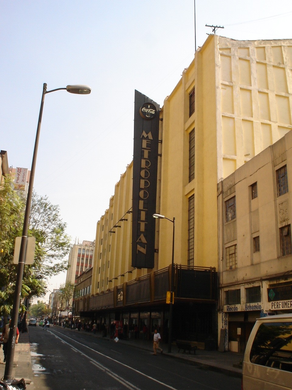
Teatro Metropólitan
Cinema and theater · 4.0 km
Music venue and theater in Mexico City, formerly a movie theater
11 more on the map.
Museums and landmarks54

Alfredo Guati Rojo National Watercolor Museum
Museum · 5.9 km
Art Museum in Mexico City
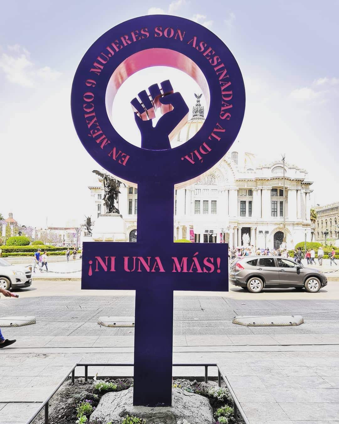
Antimonumenta
Monument and historic site · 4.3 km
Anti-monument in Mexico City

Antimonumento +43
Monument and historic site · 4.2 km
Memorial in Mexico City

Borda House
Monument and historic site · 4.4 km
Palace in Mexico City

Bust of Albert Einstein
Monument and historic site · 1.9 km
Sculpture in Mexico City, Mexico


Colon Monument
Monument and historic site · 4.7 km
Located in Buenavista, Delegación Cuauhtémoc, Mexico City. Sculpture by Manuel Vilar and base from Juan Agea.

Complejo Cultural Los Pinos
Museum · 4.0 km
Mexico City cultural complex

Copilco
Monument and historic site · 7.3 km
Archaeological site in Mexico City, Mexico

David y Miguel
Monument and historic site · 4.3 km
Antimonument in Mexico City


42 more on the map.
Parks, trails and playgrounds22


Viveros de Coyoacán
Park · 5.1 km
Parque nacional de la ciudad de México



10 more on the map.
Restaurants and cafes366

La Cebolla Morada
Restaurant · Regional, Mexican · 1.6 km
Cochinita pibil en tacos, tortas y panuchos
221 Avenida Nuevo León, Ciudad de México
Mo-Su 12:00-17:00
La Casa de Las Enchiladas (Bajío)
Restaurant · Mexican · 1.4 km
374-A Calle Bajío, Ciudad de México
Mo-Su 08:00-19:00
La Casa de la Yeya
Restaurant · Regional, Mexican · 1.6 km
303 Calle Concepción Beistegui, CDMX
Lunes 08:00 - 19:00 Martes 08:00 - 19:00 Miércoles 08:00 - 19:00...

Patisserie Dominique
Cafe · Bakery, Tea, Dessert · 1.7 km
157 Chiapas
Tu-Sa 07:30-18:30, Su 09:00-14:00
Pinche Gringo BBQ
Restaurant · Texas Bbq · 0.8 km
360 Cumbres de Maltrada, Ciudad de México
We-Fr 13:00-18:30
354 more on the map.
Where to stay15
Krystal Grand Suites Insurgentes
Motel and hotel · 1.7 km
724 Avenida Insurgentes Sur, Ciudad de México
Fiesta Inn Insurgentes Viaducto
Motel and hotel · 1.4 km
553 Insurgentes Sur, Ciudad de México
Churches and places of worship25
Shopping50
Gas and EV charging12
Schools, colleges and libraries18
Escuela Primaria Secretaria de Programación y Presupuesto
School
37 José Enrique Pestalozzi
Healthcare54
Farmacias Capuchinas
Clinic and pharmacy · 0.8 km
767 Cuauhtémoc, Ciudad de México
Map of Benito Juarez
250 places. The map loads OpenStreetMap tiles when you open it.
Getting there and nearby towns
Mexico City International Airport (MEX) is the nearest airport with scheduled flights listed in OpenStreetMap, 10 km away.
- Mexico City 5 km northeast, about 5 min by car
- Cuauhtémoc 5 km north, about 5 min by car
- Iztacalco 6 km east, about 6 min by car
- Coyoacán 6 km south, about 6 min by car
- Miguel Hidalgo 6 km northwest, about 6 min by car
- Magdalena Contreras 9 km southwest, about 9 min by car
- Tlalpan 11 km south, about 11 min by car
- Ciudad Nezahualcoyotl 15 km east, about 15 min by car
- Xochimilco 17 km south, about 17 min by car
- Ecatepec de Morelos 25 km northeast, about 25 min by car
Drive times are estimates from straight-line distance, not routes.
Local news
Headlines from INDB.
Reviews, tips and questions
Loading what members have shared...
Sources and licences
- GeoNames (CC BY 4.0): population, coordinates, regions and time zone
- OpenStreetMap contributors (ODbL 1.0): places, airports, map data
- Wikidata (CC0 1.0): elevation, founding date, time zone, website, landmarks and historic places
- Wikimedia Commons (see each image): photos
- Wikipedia (CC BY-SA 4.0): overview and history text
Photo credits
- Torre wtc mexico, Daniel Manrique ([email protected]), CC BY-SA 3.0
- Acuario Inbursa entrance, Keizers, CC BY-SA 3.0
- Entrada del Centro de Capacitación Cinematográfica, CENART, TSolange, CC BY-SA 4.0
- Plaza Roja, ITAM, ITAM, CC BY-SA 4.0
- La Feria Chapultepec Mágico, Dag Lindgren, Public domain
- Atardecer En Bellas Artes Vertical, Octavio Alonso Maya Castro, CC BY-SA 3.0
- PolyforumSiqueiros06, AlejandroLinaresGarcia, CC BY-SA 3.0
- Placa relativa a la Real y Pontificia Universidad de México, Patricia Alzuarte Díaz, CC BY-SA 3.0
- Teatro de la Ciudad de Mexico, Arturo de Albornoz, CC BY-SA 2.0
- Teatro de los Insurgentes, StellarD, CC BY-SA 4.0
- TEATRO METROPOLITAN EN EL D. F., No machine-readable author provided. JEDIKNIGHT1970 assumed (based on copyright claims)., CC BY-SA 2.5
- MainHouseAcuarela, AlejandroLinaresGarcia, CC BY-SA 4.0
- Antimonumenta 01, Wotancito, CC BY-SA 4.0
- Antimonumento +43, Eduardo Ibañez, CC BY-SA 4.0
- BordaHouseDF, Thelmadatter, CC BY-SA 3.0
- Mexico City (2018) - 591, Another Believer, CC BY-SA 4.0
- Museo Júmex front, Keizers, CC BY-SA 3.0
- Monumento a Colón (Buenavista, Ciudad de México) - 9, ProtoplasmaKid, CC BY-SA 4.0
- Los Pinos, Mexico 2018, Drkgk, CC BY-SA 4.0
- Antimonumento David y Miguel 3, Wotancito, CC BY-SA 4.0
- El Carmen Church San Angel, Ymblanter, CC BY-SA 4.0
- UpperStoriesMAPDF, AlejandroLinaresGarcia, CC BY-SA 4.0
- Alameda Central CDMX IMG 0731 (25892685445), Gobierno CDMX, CC0
- Dgzentradachapultepec, Nonbeach, CC BY-SA 3.0
- Jardín Ramón López Velarde, Haakon S. Krohn, CC BY-SA 3.0
- MonumentAlvaroObrgonDF, Thelmadatter, Public domain
- Homenaje a José José en Parque de la China - 1, ProtoplasmaKid, CC BY-SA 4.0
- Parque Hundido1, Andrés Tonini, CC BY-SA 3.0
- ClockTowerPolancoDF, Thelmadatter, Public domain
- Parque Lira - Arco de Entrada (Francesco Saverio Cavallari), Keizers, CC BY-SA 3.0
- CirclePathViverosCoyoacanDF, Thelmadatter, CC BY-SA 3.0
- FacadeSoledadDF3, Thelmadatter, CC BY-SA 3.0
- ValvaneraChurchDF, Thelmadatter, Public domain
- TEMPLO DE SAN BERNARDO 1, Tonatiuh101, CC BY-SA 3.0
- Convento de San Francisco - Ciudad de México - 1, ProtoplasmaKid, CC BY-SA 3.0
- Facade - Saint Ines Church - Mexico 2024, José Luiz, CC BY-SA 4.0
- CourtyardJLCMuseumDF, Thelmadatter, Public domain
- FacadeLaEnseñanza1DF, Thelmadatter, Public domain
- Templo de la Santísima Trinidad 2012-09-03 19-30-26, EdwinDlacruz, CC BY-SA 3.0
- Catedral Metropolitana de la Ciudad de México 1, ProtoplasmaKid, CC BY-SA 4.0
- LoretoChurchBackDF, Thelmadatter, Public domain
- JM19, Pumario2008, CC BY-SA 3.0
- Templo de Porta Coeli frente, Adán 1209, CC BY-SA 3.0
- UnADM, UNAMD, Public domain
- Jardín López Velarde 39, Álvaro de la Paz Franco, CC0


Page built November 4, 2026. Spotted a mistake? Tell us or suggest a place.