


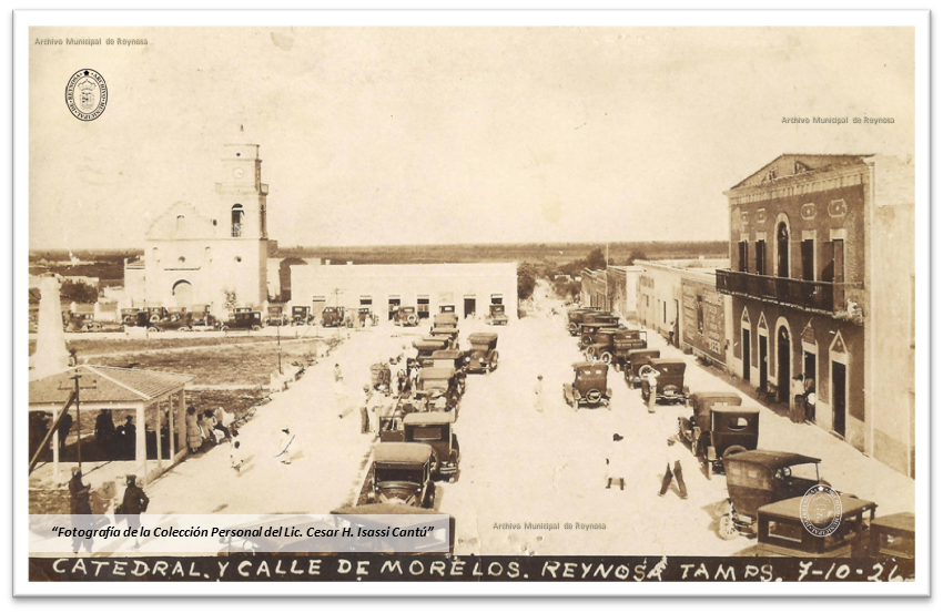

Reynosa, Mexico
Reynosa is a town of 589,466 people in Tamaulipas, Mexico, founded in March 14, 1749.
Why visit Reynosa
Townapedia lists 6 museums and landmarks, 18 parks and trails, 11 places to eat, 2 places to stay and 2 attractions in and around town.
Highlights include Anzalduas International Bridge and McAllen–Hidalgo–Reynosa International Bridge.
Weather in Reynosa
Forecast from MET Norway (CC BY 4.0). Full forecast
About Reynosa
Reynosa (Spanish pronunciation: [rejˈnosa]) is the municipal seat of Reynosa Municipality and the largest city of the state of Tamaulipas, in Mexico.
From the Wikipedia article Reynosa (this version), under CC BY-SA 4.0.
Travel tips from other travellers: Reynosa on Wikivoyage (CC BY-SA 4.0).
Things to do2

Anzalduas International Bridge
Bridge · 5.3 km
Bridge in United States of America
Museums and landmarks6


Parks, trails and playgrounds18


6 more on the map.
Restaurants and cafes11



La Hormiga
Fast food · 1.7 km
Calle Benito Juárez esq. con Ignacio Allende, Reynosa
History
On 6 July 1686, Agustín Echeverz y Zuvízar, governor of the Nuevo Reino de León, camped in what is now Reynosa during an exploratory expedition.
In December 1748, an expedition led by José de Escandón y Helguera left from Querétaro, planning to establish 14 villages; the caravan consisted of 1500 colonists and 755 soldiers.
On 14 March 1749, was founded (in its original location) the Villa de Nuestra Señora de Guadalupe de Reynosa, by the captain Carlos Cantú on behalf of Escandón, being as well in political and military command. There were 279 pioneer residents in the charge of Friar Agustín Fragoso.
The city was named Reynosa after Reinosa, birthplace of the viceroy Juan Francisco de Güemes y Horcasitas.
In August 1750, the first flood was documented in the village.
In April 1757, Reynosa had it first political conflict, when Escandón dismissed Carlos Cantú as the mayor of the village, replacing him by Pedro de Estrada, second mayor of Reynosa.
On 9 July 1757, arrives to the village the captain José Tineda y Cuervo and the engineer Agustín López, both viceroyalty inspectors, to do a population census according to which Reynosa had 280 inhabitants.
As a result of the census, they obtained authorization from the King of Spain to move the village to a placed named Santa María de las Lajas, which was not done because Escandón didn't consider the river a flooding risk anymore.
From the History section of Reynosa on Wikipedia, under CC BY-SA 4.0.
Where to stay2
Churches and places of worship1
Shopping9
Gas and EV charging2
Schools, colleges and libraries7
Biblioteca pública Agapito Cepeda Uriegas
Library · 0.8 km
630 5 de mayo, Reynosa
Healthcare8
Centro Medico Siglo XXI
Clinic and pharmacy · 1.1 km
1350 Tiburcio Garza Zamora, Reynosa
Map of Reynosa
66 places. The map loads OpenStreetMap tiles when you open it.
Getting there and nearby towns
General Lucio Blanco International Airport (REX) is the nearest airport with scheduled flights listed in OpenStreetMap, 10 km away.
- Hidalgo 5 km northeast, about 5 min by car
- Pharr 13 km northeast, about 13 min by car
- Mission 14 km north, about 14 min by car
- McAllen 17 km north, about 17 min by car
- San Juan 18 km northeast, about 18 min by car
- Palmview South 17 km northwest, about 17 min by car
- Palmview 19 km northwest, about 19 min by car
- Alamo 20 km northeast, about 20 min by car
- South Alamo 19 km northeast, about 19 min by car
- Palmhurst 20 km north, about 20 min by car
Drive times are estimates from straight-line distance, not routes.
Local news
Headlines from INDB.
Reviews, tips and questions
Loading what members have shared...
Sources and licences
- GeoNames (CC BY 4.0): population, coordinates, regions and time zone
- OpenStreetMap contributors (ODbL 1.0): places, airports, map data
- Wikidata (CC0 1.0): elevation, founding date, time zone, website, landmarks and historic places
- Wikimedia Commons (see each image): photos
- Wikipedia (CC BY-SA 4.0): overview and history text
Photo credits
- Vista desde el tejado, Robox91, CC BY-SA 3.0
- Casa Consistorial, Iglesia y Plaza durante los festejos del primer puente Internacional, 10 de Julio de 1926, Unknown author Unknown author, CC BY-SA 3.0
Page built November 4, 2026. Spotted a mistake? Tell us or suggest a place.