
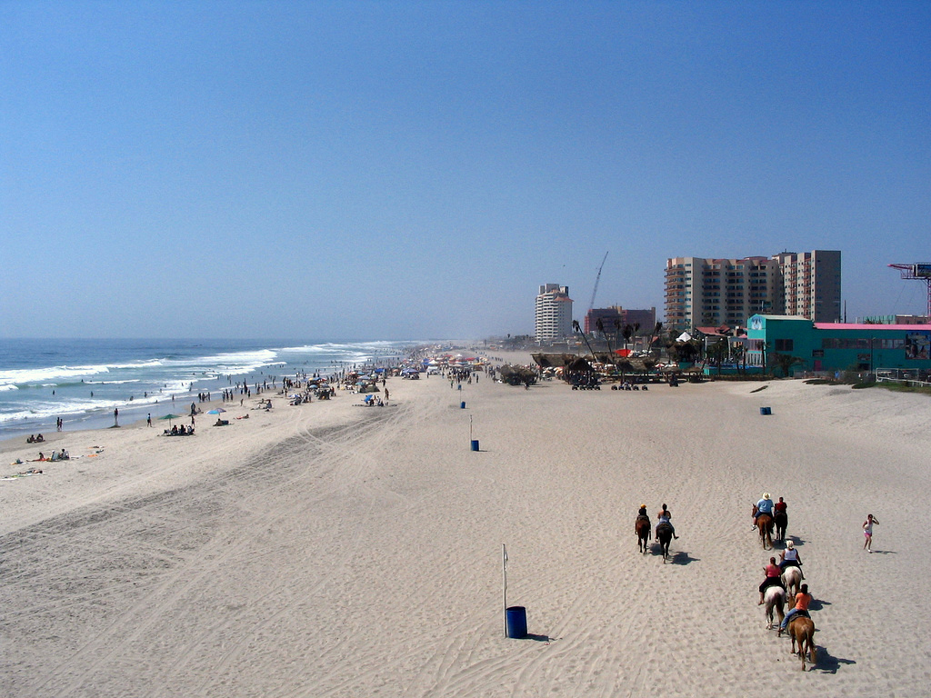


Rosarito, Mexico
Rosarito is a town of 100,660 people in Baja California, Mexico, founded in May 14, 1885.
Why visit Rosarito
Townapedia lists 5 museums and landmarks, 15 parks and trails, 47 places to eat, 13 places to stay and 3 attractions in and around town.
Highlights include Chikis818 and Ciencia y tecnologia del estado.
Weather in Rosarito
Forecast from MET Norway (CC BY 4.0). Full forecast
About Rosarito
Rosarito is a coastal city in Playas de Rosarito Municipality, Baja California, on the Pacific Coast of Mexico. As of 2010, the city had a population of 65,278. Located 10 miles (16 km) south of the US–Mexico border, Rosarito is a part of the greater San Diego–Tijuana region and one of the westernmost cities in Mexico. Rosarito is a major tourist destination, known for its beaches, resorts, and events like the Baja Beach Fest.
From the Wikipedia article Rosarito (this version), under CC BY-SA 4.0.
Things to do3


Museums and landmarks5


Ciencia y tecnologia del estado
Museum · 1.3 km
José Haros Aguilar, Playas de Rosarito
Mo-Sa 08:00-20:00
Museo de Letras
Museum · 1.5 km
José Haros Aguilar, Playas de Rosarito
Mo-Sa 08:00-20:00
Parks, trails and playgrounds15


Escuela Primaria Constitución de 1917
Park · 0.8 km
Calle Artículo 27 Constitucional, Playas de Rosarito
Parque Emiliano Zapata
Park · 1.5 km
Boulevard Benito Juárez García, Playas de Rosarito
3 more on the map.
Restaurants and cafes47

Unicycle Books & Coffee
Cafe · 2.2 km
29 Boulevard Benito Juárez García, Playas de Rosarito
Mo-Su 08:00-22:00
El Patio del Conejo Café
Cafe · Coffee, Crepe, Waffle · 2.4 km
13-4 Calle del Encino, Playas de Rosarito
Tu-Su 15:00-21:40

Fat Cat Pancake House
Restaurant · Breakfast · 2.3 km
300-7 Boulevard Benito Juárez García
Fr-We 08:00-14:00
Ji Xiang
Restaurant · Chinese · 1.2 km
6616125577 José Haroz Aguilar
toda la semana

La Escondida Antro Bar & Mucho Karaoke
Bar and pub · 2.4 km
Boulevard Benito Juárez García, Playas de Rosarito
Mo-Su 20:00-05:00
Ochuna
Restaurant · Regional, Mexicana · 1.9 km
Boulevard Benito Juárez García, Playas de Rosarito
12:30-22:30
Starbucks
Cafe · Coffee Shop · 1.7 km
Boulevard Benito Juárez García, Playas de Rosarito
Mo-Su 06:00-23:00
Tacos Manuel
Restaurant · Mexican · 1.3 km
256 Boulevard Benito Juárez García
Mo-Su 08:00-23:00
Las Potrancas
Restaurant · Mexican · 2.3 km
4A Boulevard Benito Juárez García, Playas de Rosarito
Birrieria Isabel
Restaurant · Mexican · 1.3 km
José Haros Aguilar, Playas de Rosarito
35 more on the map.
History
Evidence of the presence of Paleo-Indians in the region has been dated as early as 2,000 BC. By 1,000 BC, a group emerged that is recognizable as the Yuman ancestors of the Kumeyaay, who continued to inhabit the northern portion of the Baja California Peninsula at the time of European contact. The Kumeyaay referred to the area now known as Rosarito as Wa-cuatay, which translates to "big houses" in the Kumeyaay language.
From the History section of Rosarito on Wikipedia, under CC BY-SA 4.0.
Where to stay13
Los Pelicanos
Motel and hotel · Regional, Seafood · 2.3 km
115 Calle del Ebano, Playas de Rosarito
Las Brisas
Motel and hotel · 2.1 km
Boulevard Benito Juárez García, Playas de Rosarito
Motel Villa de Lis
Motel and hotel · 2.3 km
200 Calle Costa Azul, Playas de Rosarito
Del Sol Inn
Motel and hotel · 2.5 km
Boulevard Benito Juárez García, Playas de Rosarito
Motel ensueno
Motel and hotel · 1.6 km
Privada Rodolfo Sánchez, Playas de Rosarito
Oceana
Motel and hotel · 2.4 km
Boulevard Benito Juárez García, Playas de Rosarito
Churches and places of worship8
Iglesia de los tiempos
Church · Catholic · 1.5 km
José Haros Aguilar, Playas de Rosarito
Ministerios ELIM
Church · Christian · 1.0 km
Calle Artículo Tercero, Playas de Rosarito
Santisimo Sacramento
Church · Catholic · 0.8 km
Calle Artículo 27 Constitucional, Rosarito
Shopping14
La Esperanza 3
Hardware store · 1.0 km
Calle Artículo Tercero, Playas de Rosarito
Gas and EV charging8
Pemex
Gas station · 1.0 km
Calle Artículo 27 Constitucional;Artículo 27, Playas de Rosarito
Schools, colleges and libraries42
Secundaria Tecnica Num. 37 Amado Nervo
School · 1.3 km
Avenida Las Palmas Num. 28
Universidad Rosaritense
School
Paseo de Las Flores Num. 100, Fracc. Vista Hermosa
Centenario de La Revolucion Mexicana
School · 1.0 km
SN Arca de Noe S/N Fracc. Cumbres de Rosarito
Colegio de Bachilleres de Baja California Plantel Rosarito
School · 2.2 km
SN Juan Jacobo Rosseau S/N
Healthcare13
Similares
Clinic and pharmacy · 1.3 km
Boulevard Benito Juárez García, Playas de Rosarito
Map of Rosarito
168 places. The map loads OpenStreetMap tiles when you open it.
Getting there and nearby towns
Tijuana International Airport (TIJ) is the nearest airport with scheduled flights listed in OpenStreetMap, 21 km away.
- Tijuana 16 km north, about 16 min by car
- Imperial Beach 24 km north, about 24 min by car
- Chula Vista 30 km north, about 30 min by car
- National City 34 km north, about 34 min by car
- Coronado 35 km north, about 35 min by car
- Bonita 35 km north, about 35 min by car
- La Presa 39 km north, about 39 min by car
- Spring Valley 42 km north, about 42 min by car
- Lemon Grove 41 km north, about 41 min by car
- San Diego 53 km north, about 53 min by car
Drive times are estimates from straight-line distance, not routes.
Local news
Headlines from INDB.
Reviews, tips and questions
Loading what members have shared...
Sources and licences
- GeoNames (CC BY 4.0): population, coordinates, regions and time zone
- OpenStreetMap contributors (ODbL 1.0): places, airports, map data
- Wikidata (CC0 1.0): elevation, founding date, time zone, website
- Wikimedia Commons (see each image): photos
- Wikipedia (CC BY-SA 4.0): overview and history text
Photo credits
- Rosarito Beach, cesar bojorquez from Tijuana, Mexico, CC BY 2.0
- Rosarito's Beach, Liliana Saeb, CC BY 2.0
- The snow looks pretty well in Mexico, too (4221140430), Antonio Zugaldia from Washington, D.C., United States, CC BY 2.0
- Gaviotas, Raúl Ponce, CC BY 3.0
- Playa de Azul - panoramio, ty sterns, CC BY 3.0
Page built November 4, 2026. Spotted a mistake? Tell us or suggest a place.