


Why visit Oakville
Townapedia lists 24 museums and landmarks, 10 parks and trails, 16 places to eat and 5 attractions in and around town.
Highlights include Country Cinema, Sheffield Street Bridge, Bank Street Historic District and Benedict-Miller House.
Weather in Oakville
Forecast from the National Weather Service. Full forecast
About Oakville
Oakville is a census-designated place (CDP) and neighborhood section of Watertown, in Litchfield County, Connecticut, United States. As of the 2020 census, Oakville had a population of 9,504. It is the most populous community in Watertown, with more than twice as many people as the center village of Watertown. The ZIP code for Oakville is 06779.
From the Wikipedia article Oakville, Connecticut (this version), under CC BY-SA 4.0.
Things to do5


Sheffield Street Bridge
Bridge · National Register of Historic Places · 2.3 mi
Historic lenticular truss bridge spanning Hancock Brook in Waterbury, Connecticut

Post University
School · 3.8 mi
For-profit university in Waterbury, Connecticut

Museums and landmarks24

Bank Street Historic District
Monument and historic site · National Register of Historic Places · 3.6 mi
Listed on the NRHP
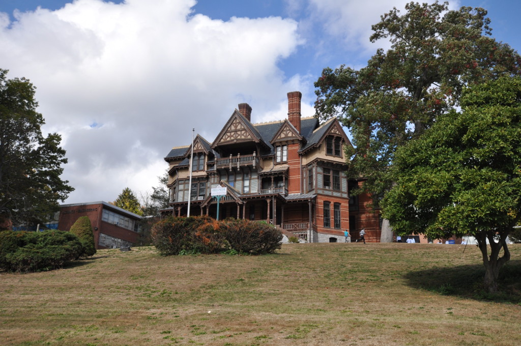
Benedict-Miller House
Monument and historic site · National Register of Historic Places · 3.2 mi
Historic house in Connecticut, United States

Beth El Synagogue
Monument and historic site · National Register of Historic Places · 3.0 mi
Synagogue in Waterbury, Connecticut, USA

Bishop School
Monument and historic site · National Register of Historic Places · 3.3 mi
Historic school building in Waterbury, Connecticut, United States

Downtown Waterbury Historic District
Monument and historic site · National Register of Historic Places · 3.3 mi
Historic district in Waterbury, Connecticut, United States

Elton Hotel
Monument and historic site · National Register of Historic Places · 3.4 mi
Historic building in Waterbury, Connecticut, United States

Enoch Hibbard House and George Granniss House
Monument and historic site · National Register of Historic Places · 3.3 mi
Historic houses in Connecticut, United States

George S. Abbott Building
Monument and historic site · National Register of Historic Places · 3.4 mi
Building in Connecticut, United States

Hillside Historic District
Monument and historic site · National Register of Historic Places · 3.2 mi
Historic district in Waterbury, Connecticut, United States

John Kendrick House
Monument and historic site · National Register of Historic Places · 3.4 mi
Historic house in Connecticut, United States

Josiah Bronson House
Monument and historic site · National Register of Historic Places · 3.4 mi
Historic house in Connecticut, United States

Nathaniel Richardson House
Monument and historic site · National Register of Historic Places · 3.1 mi
Historic house on Kelly Street in Middlebury, Connecticut
12 more on the map.
Parks, trails and playgrounds10


Lewis Fulton Memorial Park
Park · National Register of Historic Places · 2.9 mi
Park in Waterbury, United States of America


Sylvan Lake Park
Hiking and trails · 1.2 mi
Municipal, Open To Public Without Fee
Restaurants and cafes16

Gayle's Depot Square Farm Shoppe
Restaurant · Diner · 1.5 mi
51 Depot Street, Watertown
Mo-We 07:00-15:00; Th-Sa 07:00-19:00; Su 07:00-13:00
Mary's Diner
Restaurant · Breakfast, American · 2.1 mi
579 Watertown Avenue, Waterbury
Mo-Su 06:00-15:00
Simply Bowls & Co.
Restaurant · 1.7 mi
469 Main Street, Watertown
Tu-Th 09:00-16:00; Fr 08:00-16:00; Sa 08:00-15:00

Thai BowL
Restaurant · Thai · 1.7 mi
515 Main Street, Watertown
Mo-Th 11:30-21:00; Fr-Sa 11:30-22:00



Dunkin'
Fast food · Donut, Coffee Shop · 1.0 mi
1174 Main Street;Main Street West, Watertown
Mo-Sa 04:00-21:00; Su 05:00-21:00
4 more on the map.
Churches and places of worship7
Our Lady of Loreto Church
Church · Catholic · 1.4 mi
12;635 Ardsley Road;Bunker Hill Avenue, Watertown;Waterbury
Walnut Hill Community Church Waterbury Campus
Church · Evangelical · 1.8 mi
274 Bunker Hill Avenue, Waterbury
Saint Mary Magdalene Catholic Church
Church · Roman Catholic · 0.4 mi
2 Buckingham Street, Watertown
Union Congregational Church
Church · United Church Of Christ · 0.4 mi
167 Buckingham Street, Watertown
Shopping3
Gas and EV charging4
Schools, colleges and libraries49
Healthcare2
Map of Oakville
120 places. The map loads OpenStreetMap tiles when you open it.
People and cost of living
American Community Survey 5-year estimates, 2020-2024, U.S. Census Bureau. Estimates have margins of error, larger for small towns.
Disaster history
The county has had 23 federal disaster declarations since 2000, most often for hurricanes.
- 2024-09-20: Severe Storm, Flooding, Landslides, And Mudslides (Severe Storm)
- 2024-08-21: Severe Storms, Flooding, Landslides, And Mudslides (Severe Storm)
- 2021-10-30: Remnants Of Hurricane Ida (Hurricane)
- 2021-08-22: Hurricane Henri (Hurricane)
- 2021-01-12: Tropical Storm Isaias (Hurricane)
- 2020-08-06: Tropical Storm Isaias (Hurricane)
OpenFEMA disaster declarations summaries.
Getting there and nearby towns
Waterbury-Oxford Airport (OXC) is the nearest airport with scheduled flights listed in OpenStreetMap, 8 miles away.
- Waterbury 3 mi southeast, about 6 min by car
- Naugatuck 7 mi south, about 12 min by car
- Woodbury Center 7 mi southwest, about 11 min by car
- Bethlehem Village 7 mi northwest, about 11 min by car
- Bristol 10 mi northeast, about 16 min by car
- Heritage Village 10 mi southwest, about 17 min by car
- Cheshire Village 12 mi southeast, about 19 min by car
- Litchfield 12 mi northwest, about 19 min by car
- Northwest Harwinton 13 mi north, about 21 min by car
- Meriden 16 mi east, about 25 min by car
Drive times are estimates from straight-line distance, not routes.
Local news
Headlines from INDB, the NEMICO news database.
Reviews, tips and questions
Loading what members have shared...
Sources and licences
- NCES EDGE (Public domain): public schools
- OpenFEMA (Public domain): disaster declarations
- OpenStreetMap contributors (ODbL 1.0): places, airports, map data
- U.S. Census Bureau (Public domain): population, income, housing, education, commute
- Wikidata (CC0 1.0): elevation, founding date, time zone, website, landmarks and historic places
- Wikimedia Commons (see each image): photos
- Wikipedia (CC BY-SA 4.0): overview and history text
Photo credits
- Main Street, Oakville CT, John Phelan, CC BY-SA 4.0
- Post Office, Oakville CT, John Phelan, CC BY-SA 4.0
- Streetcars in Oakville postcard, Unknown author Unknown author, Public domain
- Saint Mary Magdalene Catholic Church, Oakville CT, John Phelan, CC BY-SA 4.0
- Oakville, CT, CTsignhunt, CC0
- John Kendrick House, Waterbury, CT, Daniel Case, CC BY-SA 3.0
- WaterburyCT BethElSynagogue, Magicpiano, CC BY-SA 4.0
- NathanielRichardsonHouse, Bruce Clouette, Public domain
- WaterburyCT HillsideHD 4, Magicpiano, CC BY-SA 4.0
- Downtown Waterbury, CT, Daniel Case, CC BY-SA 3.0
- PalaceTheater-WaterburyCT-1, Koskenart, CC BY-SA 4.0
- MiddleburyCT JosiahBronsonHouse, Magicpiano, CC BY-SA 4.0
- MunsonMemorialParkWatertownCT, Jerry Dougherty, CC BY 2.5
- WaterburyCT WaterburyClockCompany, Magicpiano, CC BY-SA 4.0
- WaterburyCT HibbardAndGrannissHouses, Magicpiano, CC BY-SA 4.0
- Bank Street Historic District, Waterbury, CT, Daniel Case, CC BY-SA 3.0
- WaterburyCT WebsterSchool, Magicpiano, CC BY-SA 4.0
- Elton Hotel, Waterbury, CT, Daniel Case, CC BY-SA 3.0
- Sheffield Street Bridge spanning Hancock Brook. 9-17-2013, Robert E. Brown, CC BY-SA 3.0
- Grand entrance to the school April 2015 jpg, Robert E. Brown, CC BY-SA 4.0
- WaterburyCT BishopSchool, Magicpiano, CC BY-SA 4.0
- WaterburyCT OverlookHD 3, Magicpiano, CC BY-SA 4.0
- WaterburyCT HillsideHD 2, Magicpiano, CC BY-SA 4.0
- WaterburyCT GeorgeSAbbottBuilding, Magicpiano, CC BY-SA 4.0
- Stone Gazebo, Fulton Park, Waterbury, Ct. 6-7-14, Robert E. Brown, CC BY-SA 3.0
- Chase Building, Waterbury, CT, Daniel Case, CC BY-SA 3.0
- Mattatuck Museum 1 - front exterior, Jllm06, CC BY-SA 4.0
- Torrance Hall, Wipost, CC BY-SA 4.0
- CFPAWhitestoneCliffsTrailView1, H. Morrow Long, CC BY-SA 3.0
- Watertown High School, Watertown CT, John Phelan, CC BY 4.0
- ISS043-E-243803 - View of Earth, Earth Science and Remote Sensing Unit , Lyndon B. Johnson Space Center, Public domain
- ISS014-E-17464 - View of New York, Earth Science and Remote Sensing Unit , Lyndon B. Johnson Space Center, Public domain
- ISS043-E-243804 - View of Earth, Earth Science and Remote Sensing Unit , Lyndon B. Johnson Space Center, Public domain
- ISS049-E-1281 - View of Earth, Earth Science and Remote Sensing Unit , Lyndon B. Johnson Space Center, Public domain
- Red Squirrel, Mathew Schwartz, CC BY 3.0
- Piping Plover Migration, Mathew Schwartz, CC BY 3.0
- Hawk Above, Mathew Schwartz, CC BY 3.0
- Face To Face, Nduja974, CC0
- Endangered Piping Plover, Mathew Schwartz, CC BY 3.0
- Mystery Woman (Unsplash), Zach Guinta zach_guinta, CC0


Page built October 30, 2026. Spotted a mistake? Tell us or suggest a place.