
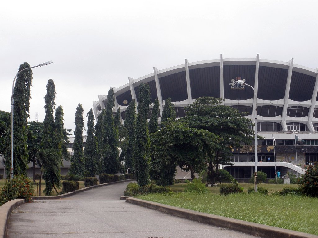


Why visit Surulere
Townapedia lists 6 museums and landmarks, 5 parks and trails, 7 places to eat, 8 places to stay and 11 attractions in and around town.
Highlights include Ozone Cinema, Apapa Amusement Park, National Arts Theatre and Centre For Black And African Arts And Civilization.
Weather in Surulere
Forecast from MET Norway (CC BY 4.0). Full forecast
About Surulere
Surulere () is a city and local government area located on the mainland in Lagos State, Nigeria. It has an area of 23 km2 (8.9 sq mi). At the 2006 census, there were 503,975 inhabitants, with a population density of 21,864 inhabitants per square kilometer. The local government area is bordered by Yaba, Mushin, and Ebute-Metta.
From the Wikipedia article Surulere (this version), under CC BY-SA 4.0.
Travel tips from other travellers: Surulere on Wikivoyage (CC BY-SA 4.0).
Things to do11

Apapa Amusement Park
Monument and historic site · 6.5 km
Theme park in Lagos, Nigeria


Delta State University, Abraka
School · 3.5 km
Public state-owned university in Abraka town, in Ethiope-East Local Government Area, Delta State, Nigeria


Lagos Business School
School · 7.4 km
School for intending business professionals established in Lagos State
Lebanese Community School
School · 1.9 km
An academic institution in Nigeria
Nigerian University of Technology and Management
School · 5.8 km
University in Nigeria


University of Lagos
School · 3.5 km
Public research university in Lagos, Nigeria
Museums and landmarks6

National Arts Theatre
Monument and historic site · 3.1 km
Theater in Lagos, Nigeria

Centre For Black And African Arts And Civilization
Museum · 6.9 km
CBAAC is a parastatal under the Federal Ministry of Culture and Information which is statutorily charged with the responsibility of...

National Gallery of Modern Art
Museum · 3.1 km
National gallery in Nigeria

Rio de la plata
Monument and historic site · 5.3 km
Official residence of Oba of Lagos, Lagos Nigeria

Tinubu Square
Monument and historic site · 6.3 km
Landmark in Lagos, Nigeria
Parks, trails and playgrounds5




Restaurants and cafes7




History
During the rapid urbanization of Lagos, the city expanded to the west of its lagoon, which included present-day Surulere. Families from different regions of the country have historically settled in Surulere. In addition to the local settlers of Lagos, during the nineteenth century, various emancipated African Brazilians and Cubans, who were referred to as Aguda or Saros, settled in Surulere. Nigerians from the Northern region initially ended at Idi-Araba, while many people from the eastern part were in various quarters but predominantly at Obele, Ikate, and Aguda areas. Residents of Lagos Island who bought or leased land from the government and Aworis settled in New Lagos. In contrast, others lived in the neighborhoods of Itire, Lawanson, Ojuelegba, Animashaun, and Shitta. The New Lagos neighborhood, also known as the Surulere Re-Housing Estate, is among the first public housing projects in Nigeria. Itire, one of the quarters in Surulere, has a recognized traditional authority in the Onitire of Itire.
From the History section of Surulere on Wikipedia, under CC BY-SA 4.0.
Where to stay8
Churches and places of worship26
Anwar-ul-Islam Islamic Movement
Place of worship · 3.3 km
Layi Oyekanmi Street, Mushin
Shopping5
Gas and EV charging11
Schools, colleges and libraries22
Healthcare105
Map of Surulere
206 places. The map loads OpenStreetMap tiles when you open it.
Getting there and nearby towns
Murtala Mohammed International Airport (LOS) is the nearest airport with scheduled flights listed in OpenStreetMap, 9 km away.
- Mushin 3 km north, about 3 min by car
- Shomolu 5 km northeast, about 5 min by car
- Aiyetoro 5 km south, about 5 min by car
- Lagos 7 km southeast, about 7 min by car
- Ajegunle 6 km southwest, about 6 min by car
- Oshodi 6 km north, about 6 min by car
- Aliayabiagba 6 km southwest, about 6 min by car
- Obalende 9 km southeast, about 9 min by car
- Ikeja 11 km north, about 11 min by car
- Agege 13 km north, about 13 min by car
Drive times are estimates from straight-line distance, not routes.
Local news
Headlines from INDB.
Reviews, tips and questions
Loading what members have shared...
Sources and licences
- GeoNames (CC BY 4.0): population, coordinates, regions and time zone
- OpenStreetMap contributors (ODbL 1.0): places, airports, map data
- Wikidata (CC0 1.0): elevation, founding date, time zone, website, landmarks and historic places
- Wikimedia Commons (see each image): photos
- Wikipedia (CC BY-SA 4.0): overview and history text
Photo credits
- 2009 National Arts Theatre Lagos Nigeria 6350723082, crashdburnd, CC BY-SA 2.0
- Main-bowl-national-stadium-surulere-lagos, S.aderogba, CC BY-SA 4.0
- Main-bowl-teslim-balogun-stadium-surulere-lagos, S.aderogba, CC BY-SA 4.0
- Indoor-sports-complex-national-stadium-surulere-lagos, S.aderogba, CC BY-SA 4.0
- Super Star, Freak Out and KMG Booster, night, Unknown author, CC BY-SA 2.0
- Carter Brdge 001, Solasly, CC BY-SA 4.0
- Main gate, Douglas Oraka, CC BY-SA 3.0
- Eko cater bridge in Lagos State-Nigeria, Omoeko Media, CC BY-SA 4.0
- Third-mainland-bridge--lagos 2, S.aderogba, CC BY-SA 4.0
- Garden front of National Theater, Iganmu, Lagos, Omoeko Media, CC BY-SA 4.0
- Iga iduganran, Yeniajayiii, CC BY-SA 4.0
- 2014 Tinubu Square Lagos Nigeria 14640600637, Jeremy Weate from Abuja, Nigeria, CC BY 2.0
- Holy Cross Cathedral Lagos, Kelechinaba, CC BY-SA 4.0
- University of Lagos2, Contimm at English Wikipedia, Public domain
- National arts theatre (19799909141), dotun55, CC BY-SA 2.0
- Mechanical workshop, Yabatech, Abiolakintrunde, CC BY-SA 4.0
- Cross segment of igbobi college front view, Bamidele Olaoluwa Emmanuel, CC BY-SA 4.0
- Nurse checking triplets, Mike Blyth, CC BY-SA 3.0
- National Orthopedic Hospital, Igbobi, Kaizenify, CC BY-SA 4.0
- MORNING MARKET, Koyejoadejoye, CC BY-SA 4.0
- (Photo-walk Nigeria),front view of the Federal College of Education (Tech), Yemi festus, CC BY-SA 4.0
- National Stadium Surulere, Juganutt, CC BY-SA 4.0
- Yaba Tech second gate, Official alade, CC BY-SA 4.0
- Igbobi autopedic hospital Lagos, Olayinka luqman oniyo (Blacksaltphotography), CC BY-SA 4.0
- Eyo festival stilt performer, Slashme, CC BY-SA 3.0
- Fire carrier, Slashme, CC BY-SA 3.0
- Young Eyo from above, Slashme, CC BY-SA 3.0
- Eyo Iga Etti with fire carrier, Slashme, CC BY-SA 3.0
- Eyo Iga Opeluwa banner, Slashme, CC BY-SA 3.0
- Young Eyo, Slashme, CC BY-SA 3.0
- Eyo Olokun, Slashme, CC BY-SA 3.0
- CrouchingEyo, Slashme, CC BY-SA 3.0
- Eyo Iga Etti, Slashme, CC BY-SA 3.0
- Eyo Iga Taiwo Olowo banner, Slashme, CC BY-SA 3.0
- Young Eyo performers, Slashme, CC BY-SA 3.0
- Eyo Awise banner, Slashme, CC BY-SA 3.0
- Eyo Iga Jump, Slashme, CC BY-SA 3.0
- Eko O Ni Baje bus, Slashme, CC BY-SA 3.0
- Eyo Iga Faji procession, Slashme, CC BY-SA 3.0
- Branded food, Slashme, CC BY-SA 3.0


Page built November 3, 2026. Spotted a mistake? Tell us or suggest a place.