



Why visit North Oaks
Townapedia lists 3 museums and landmarks, 25 parks and trails and 8 places to eat in and around town.
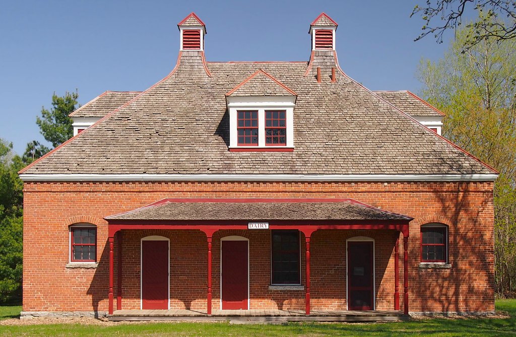
Highlights include E. H. Hobe House-Solheim, James J. Hill's North Oaks Farm, Dairy Building, Shamrock Park and Bucher Park.
July is the warmest month, with average highs of 83°F; January lows average 8°F.
Weather in North Oaks
Forecast from the National Weather Service. Full forecast
About North Oaks
North Oaks is an exurban city 10 miles (16 km) north of St. Paul in Ramsey County in the U.S. state of Minnesota. The population was 5,272 at the 2020 census.
From the Wikipedia article North Oaks, Minnesota (this version), under CC BY-SA 4.0.
Museums and landmarks3


E. H. Hobe House-Solheim
Monument and historic site · National Register of Historic Places · 3.7 mi
Historic house in Minnesota, United States

James J. Hill's North Oaks Farm, Dairy Building
Monument and historic site · National Register of Historic Places · 0.9 mi
Building in North Oaks, Minnesota, United States

Parks, trails and playgrounds25

Shamrock Park
Park · 3.3 mi
Park in Shoreview, Minnesota, United States

13 more on the map.
Restaurants and cafes8

Big Dipper Creamery
Ice cream · 1.8 mi
115 Village Center Drive, North Oaks
Mo-Sa 11:00-21:00, Su 13:00-21:00

Suishin Japanese Restaurant
Restaurant · Japanese, Sushi · 1.8 mi
A Japanese restaurant with a small sushi bar. Quiet and peaceful. In a strip mall just off Highway 96.
125 Village Center Drive


Jersey Mike's Subs
Fast food · Sandwich · 1.8 mi
119B Village Center Drive, North Oaks
Su-Sa 10:00-21:00
Churches and places of worship2

History
Structured around Pleasant Lake, the area began as a water source for the Saint Paul municipal water system, which still maintains water access rights today. The land was later purchased by Saint Paul magnate James J. Hill in 1883 and expanded into a 5,000-acre (20 km2) breeding and hobby farm.
Hill's son, Louis, later owned North Oaks Farm until his death in 1948. Ownership passed to Louis' children who decided to develop the land into a model residential community. They incorporated the North Oaks Company with a mission to build with respect for the natural environment, having witnessed metropolitan sprawl during this time. To ensure their mission would be fulfilled, land was subdivided and sold with a warranty deed that created the North Oaks Home Owners’ Association (NOHOA) to be responsible for roads and recreation. Each deed placed each home's property line halfway into the street, placing all roads into private ownership.
The remaining land in the city is owned by the North Oaks Company. The original farm buildings have been restored with informational displays. They are not open to the public, however, as North Oaks is private. Two of the remaining structures, the Blacksmith Shop and Machine Shop and Dairy Building, are listed on the National Register of Historic Places.
From the History section of North Oaks, Minnesota on Wikipedia, under CC BY-SA 4.0.
Shopping1
Gas and EV charging3
Schools, colleges and libraries42
Healthcare2
Map of North Oaks
86 places. The map loads OpenStreetMap tiles when you open it.
Climate by month
Monthly table
| Month | High | Low | Rain |
|---|---|---|---|
| Jan | 25°F | 8°F | 0.8 in |
| Feb | 30°F | 11°F | 0.8 in |
| Mar | 42°F | 24°F | 1.5 in |
| Apr | 56°F | 37°F | 3.1 in |
| May | 69°F | 50°F | 4.3 in |
| Jun | 79°F | 60°F | 4.5 in |
| Jul | 83°F | 64°F | 4.5 in |
| Aug | 81°F | 62°F | 4.5 in |
| Sep | 73°F | 54°F | 3.1 in |
| Oct | 59°F | 42°F | 3.1 in |
| Nov | 43°F | 28°F | 1.8 in |
| Dec | 30°F | 16°F | 1.1 in |
U.S. Climate Normals 1991-2020 for Vadnais Lake (4 mi away), NOAA NCEI.
People and cost of living
American Community Survey 5-year estimates, 2020-2024, U.S. Census Bureau. Estimates have margins of error, larger for small towns.
Disaster history
Ramsey County has had 10 federal disaster declarations since 2000, most often for floods.
- 2020-04-07: Covid-19 Pandemic (Biological)
- 2020-03-13: Covid-19 (Biological)
- 2019-06-12: Severe Winter Storm, Straight-Line Winds, And Flooding (Flood)
- 2014-07-21: Severe Storms, Straight-Line Winds, Flooding, Landslides, And Mudslides (Flood)
- 2011-05-10: Severe Storms And Flooding (Flood)
- 2010-04-19: Flooding (Flood)
OpenFEMA disaster declarations summaries.
Getting there and nearby towns
St. Paul Downtown Airport (STP) is the nearest airport with scheduled flights listed in OpenStreetMap, 12 miles away.
- Shoreview 2 mi southwest, about 4 min by car
- Vadnais Heights 4 mi southeast, about 6 min by car
- Circle Pines 4 mi northwest, about 6 min by car
- Lino Lakes 4 mi north, about 6 min by car
- Arden Hills 4 mi southwest, about 6 min by car
- Lexington 4 mi northwest, about 7 min by car
- White Bear Lake 5 mi southeast, about 8 min by car
- Mounds View 5 mi west, about 8 min by car
- Centerville 5 mi northeast, about 8 min by car
- New Brighton 6 mi southwest, about 9 min by car
Drive times are estimates from straight-line distance, not routes.
Local news
Headlines from INDB, the NEMICO news database.
Reviews, tips and questions
Loading what members have shared...
Sources and licences
- NCES EDGE (Public domain): public schools
- NOAA NCEI U.S. Climate Normals 1991-2020 (Public domain): climate by month
- OpenFEMA (Public domain): disaster declarations
- OpenStreetMap contributors (ODbL 1.0): places, airports, map data
- U.S. Census Bureau (Public domain): population, income, housing, education, commute
- Wikidata (CC0 1.0): elevation, founding date, time zone, website, landmarks and historic places
- Wikimedia Commons (see each image): photos
- Wikipedia (CC BY-SA 4.0): overview and history text
Photo credits
- 2009-0810-NorthOaks-HillFarm, Bobak Ha'Eri, CC BY 3.0
- North Oaks Farm Dairy Building, McGhiever, CC BY-SA 3.0
- E. H. Hobe House, McGhiever, CC BY-SA 3.0
- ISS018-E-16177 - View of Earth, Earth Science and Remote Sensing Unit , Lyndon B. Johnson Space Center, Public domain
- ISS023-E-6557 - View of Earth, Earth Science and Remote Sensing Unit , Lyndon B. Johnson Space Center, Public domain
- Nepa apiculata 571126515, Dr Ben Cull, CC BY 4.0
- Gray Tree Frog (20060078473), U.S. Fish and Wildlife Service - Midwest Region, Public domain
- 2016-08-05 20 15 07 View south towards downtown Saint Paul, Ramsey County, Minnesota from a plane departing Minneapolis-Saint Paul International Airport, Famartin, CC BY-SA 4.0
- User'sPicture, Hashi10, CC0
- Lake Johanna Fire Department - Shoreview, MN - panoramio, Gabriel Vanslette, CC BY 3.0
- Lexington and Co. Rd I - Shoreview, MN - panoramio, Gabriel Vanslette, CC BY 3.0
- Wilhelm (William) Nast, Photo originally taken at Baker's Art Gallery. 106 South High St. Columbus Ohio., CC BY-SA 4.0
- Wilhelm (William) Nast (cropped), Photo originally taken at Baker's Art Gallery. 106 South High St. Columbus Ohio., CC BY-SA 4.0
- ParthenocissusVitacea, AndyKorth, CC BY-SA 3.0
- Mycena haematopus 326170462, Kevin C, CC0
- Mycena haematopus 326170434, Kevin C, CC0


Page built October 30, 2026. Spotted a mistake? Tell us or suggest a place.