


North Ridgeville, Ohio
North Ridgeville is a city of 36,627 people in Lorain County, Ohio.
Why visit North Ridgeville
Townapedia lists 6 museums and landmarks, 39 parks and trails, 72 places to eat, 1 place to stay and 3 attractions in and around town.
Highlights include Aut-o-Rama Drive-in, Regal Cinemas 20, Elyria High School and Avon Isle.
July is the warmest month, with average highs of 85°F; January lows average 22°F, and about 44 inches of snow fall in a normal year.
Weather in North Ridgeville
Forecast from the National Weather Service. Full forecast
About North Ridgeville
North Ridgeville is a city located along the eastern border of Lorain County, Ohio, United States. The city's population was 35,280 as of the 2020 census. A part of the Cleveland metropolitan area, North Ridgeville is the fastest-growing city in northern Ohio. It has been ranked the 13th safest city in the United States and the safest in Ohio.
From the Wikipedia article North Ridgeville, Ohio (this version), under CC BY-SA 4.0.
Things to do3

Olde Towne Hall Theatre
Cinema and theater
36119 Center Ridge Road, North Ridgeville
Museums and landmarks6

Elyria High School
Monument and historic site · National Register of Historic Places · 4.7 mi
High school in Ohio, United States
601 Middle Ave, Elyria
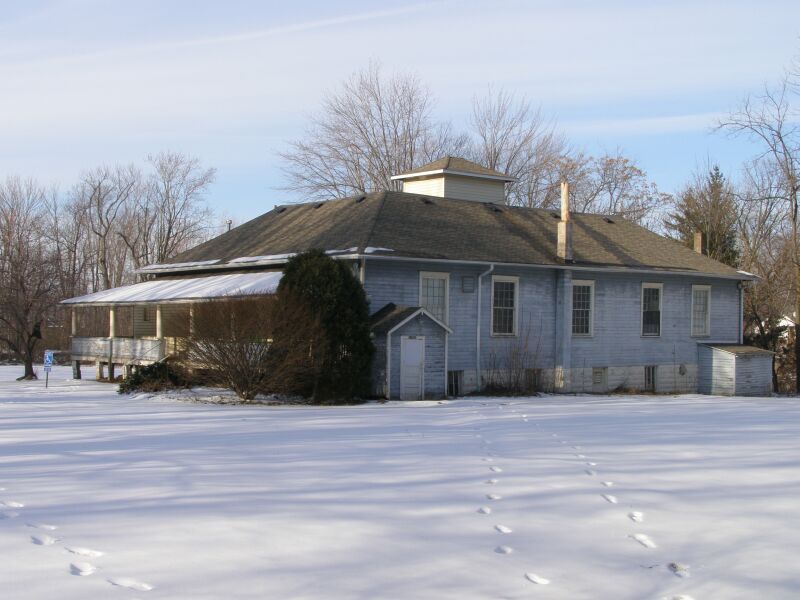
Avon Isle
Monument and historic site · National Register of Historic Places · 4.4 mi
Building in Ohio, United States

Elyria Elks Club
Monument and historic site · National Register of Historic Places · 4.6 mi
Building in Ohio, United States

St. Mary's Roman Catholic Church
Monument and historic site · National Register of Historic Places · 4.6 mi
Church in Elyria, Ohio, USA
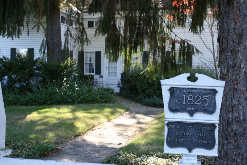
Wilbur Cahoon House
Monument and historic site · National Register of Historic Places · 4.2 mi
Historic house in Ohio, United States

Parks, trails and playgrounds39






27 more on the map.
Restaurants and cafes72

Pizza Pan
Restaurant · Pizza, Italian · 2.1 mi
33009 Lorain Road, North Ridgeville
Tu-Th 10:00-21:00; Fr 10:00-23:00; Sa 10:00-22:00; Su 10:00-21:00

Cookies' 10 Pin
Bar and pub · 3.0 mi
252 South Abbe Road, Elyria
Mo-Th 16:00-24:00; Fr-Sa 12:00-01:00; Su 16:00-24:00


Unplugged Brewing Co.
Brewery and winery · 4.1 mi
201 East Bridge Street
Mo-Th 16:00-22:00; Fr 16:00-23:00; Sa 11:00-23:00; Su 11:00-22:00
Angelina's Pizza
Restaurant · Italian · 2.0 mi
34887 Lorain Road, North Ridgeville
Biggby Coffee
Cafe · Coffee Shop · 1.0 mi
35065 Center Ridge Road, North Ridgeville
Corso's Italian Restaurant
Restaurant · Italian · 4.0 mi
29691 Lorain Road, North Olmsted

60 more on the map.
History
The first settlement of what is now North Ridgeville was made in 1810. The village was named for a ridge near the original town site.
The former North Ridgeville Town Hall and Samuel C. Cahoon House are listed on the National Register of Historic Places.
From the History section of North Ridgeville, Ohio on Wikipedia, under CC BY-SA 4.0.
Where to stay1
Churches and places of worship20
First Church of Christ, Scientist
Church · National Register of Historic Places · 4.5 mi
First United Methodist Church
Church · National Register of Historic Places · 4.6 mi
First Universalist Church of Olmsted
Church · National Register of Historic Places · 5.3 mi
Old St. John's Church
Church · National Register of Historic Places · 4.7 mi
St. Andrew's Episcopal Church
Church · National Register of Historic Places · 4.6 mi
Christ the King Vineyard Church
Church · Evangelical · 3.5 mi
30635 Lorain Road, North Olmsted
College Heights Baptist Church
Church · Baptist · 3.4 mi
980 North Abbe Road, Elyria
Faith Baptist Temple
Church · Baptist · 1.8 mi
34361 Lorain Road, North Ridgeville
The Church of Saint Clarence
Church · Catholic · 3.7 mi
30106 Lorain Road, North Olmsted
Shopping15
Gas and EV charging15
Schools, colleges and libraries42
Lake Ridge Academy
School · 0.9 mi
37501 Center Ridge Road, North Ridgeville
North Ridgeville High School
School · 1.1 mi
34600 Bainbridge Road, North Ridgeville
Healthcare15
Cleveland Clinic - Sheffield Family Health Center
Clinic and pharmacy · 3.6 mi
5334 Meadow Lane, Sheffield Village
Cleveland Clinic - Family Health & Surgery Center
Hospital · 3.6 mi
303 Chestnut Commons Drive, Elyria
Cleveland Clinic Medical Outpatient Center
Clinic and pharmacy · 1.1 mi
34960 Center Ridge Road, North Ridgeville
Cleveland Clinic Primary Care & Optometry Services
Clinic and pharmacy · 0.9 mi
35105 Center Ridge Road, North Ridgeville
Discount Drug Mart
Clinic and pharmacy · 1.9 mi
33633 Bagley Road, North Ridgeville
Discount Drug Mart
Clinic and pharmacy · 3.8 mi
5298 Detroit Road, Sheffield Village
Map of North Ridgeville
228 places. The map loads OpenStreetMap tiles when you open it.
Climate by month
Monthly table
| Month | High | Low | Rain | Snow |
|---|---|---|---|---|
| Jan | 36°F | 22°F | 2.8 in | 12.9 in |
| Feb | 40°F | 23°F | 2.4 in | 10.2 in |
| Mar | 49°F | 30°F | 3.0 in | 7.6 in |
| Apr | 63°F | 40°F | 3.8 in | 1.9 in |
| May | 73°F | 51°F | 3.9 in | 0.0 in |
| Jun | 81°F | 60°F | 4.0 in | 0.0 in |
| Jul | 85°F | 65°F | 4.1 in | 0.0 in |
| Aug | 83°F | 63°F | 4.1 in | 0.0 in |
| Sep | 77°F | 56°F | 4.0 in | 0.0 in |
| Oct | 65°F | 46°F | 3.6 in | 0.0 in |
| Nov | 52°F | 36°F | 3.0 in | 2.2 in |
| Dec | 41°F | 27°F | 3.1 in | 8.8 in |
U.S. Climate Normals 1991-2020 for Elyria 3 E (2 mi away), NOAA NCEI.
People and cost of living
American Community Survey 5-year estimates, 2020-2024, U.S. Census Bureau. Estimates have margins of error, larger for small towns.
Disaster history
Lorain County has had 9 federal disaster declarations since 2000, most often for severe storms.
- 2020-03-31: Covid-19 Pandemic (Biological)
- 2020-03-13: Covid-19 (Biological)
- 2012-06-30: Severe Storms (Severe Storm)
- 2005-09-13: Hurricane Katrina Evacuation (Hurricane)
- 2005-02-15: Severe Winter Storms, Flooding, And Mudslides (Severe Storm)
- 2004-09-19: Severe Storms And Flooding (Severe Storm)
OpenFEMA disaster declarations summaries.
Getting there and nearby towns
Cleveland Hopkins International Airport (CLE) is the nearest airport with scheduled flights listed in OpenStreetMap, 9 miles away.
- Elyria 4 mi west, about 6 min by car
- Avon 4 mi north, about 7 min by car
- North Olmsted 6 mi east, about 9 min by car
- Westlake 6 mi northeast, about 10 min by car
- Avon Lake 7 mi north, about 12 min by car
- Berea 8 mi east, about 14 min by car
- Lorain 9 mi northwest, about 14 min by car
- Bay Village 9 mi northeast, about 14 min by car
- Fairview Park 10 mi northeast, about 15 min by car
- Rocky River 11 mi northeast, about 17 min by car
Drive times are estimates from straight-line distance, not routes.
Local news
Headlines from INDB, the NEMICO news database.
Reviews, tips and questions
Loading what members have shared...
Sources and licences
- NCES EDGE (Public domain): public schools
- NOAA NCEI U.S. Climate Normals 1991-2020 (Public domain): climate by month
- OpenFEMA (Public domain): disaster declarations
- OpenStreetMap contributors (ODbL 1.0): places, airports, map data
- U.S. Census Bureau (Public domain): population, income, housing, education, commute
- Wikidata (CC0 1.0): elevation, founding date, time zone, website, landmarks and historic places
- Wikimedia Commons (see each image): photos
- Wikipedia (CC BY-SA 4.0): overview and history text
Photo credits
- North Ridgeville City Hall with water tower, Nyttend, Public domain
- North Ridgeville First Congregational UCC, Nyttend, Public domain
- Elyria 3-12-24 thumbnail IMG 5732, SilentMatt Psychedelic, CC BY-SA 4.0
- First Universalist Church of Olmsted, Carl F. Waite, Public domain
- Burger King near downtown Elyria, Nyttend, Public domain
- First Church of Christ, Scientist, TnrSmith, CC BY-SA 3.0
- 2940 Stoney Ridge Wilbur Cahoon Home IMG 2073, Chris Light, CC BY-SA 3.0
- StAndrews Episcopal Church Elyria OH, TnrSmith, CC BY-SA 3.0
- StMary"s Catholic Church Elyria OH, TnrSmith, CC BY-SA 3.0
- First United Methodist Elyria OH, TnrSmith, CC BY-SA 3.0
- Elyria Elks Club, Nyttend, Public domain
- Avon Isle Park22, Chris Light, CC BY-SA 3.0
- 2004 Ford Ranger XLT Regular Cab in Oxford White, front right, 09-26-2026, Cutlass, CC0
- Samuel C. Cahoon House, Nyttend, Public domain
- 2024 Total Solar Eclipse Creative Commons No. 2 - Flickr - wx412, James Watt, CC0
- 2024 Total Solar Eclipse Creative Commons No. 1 (53641779786), James Watt, CC0
- 2024 Total Solar Eclipse Creative Commons No. 1 (CROPPED) (53643120298), James Watt, CC0
- Anas platyrhynchos × acuta, Ben Meredyk, CC BY 4.0
- Silver-tailed Petalcutter imported from iNaturalist photo 22960505 on 27 February 2022, (c) Amy Schnebelin, some rights reserved (CC BY), CC BY 4.0
- Parasitellus (Ohio, USA), Amy Schnebelin, CC BY 4.0
- Patchwork Leafcutter Bee imported from iNaturalist photo 50948271 on 17 November 2023, (c) Amy Schnebelin, some rights reserved (CC BY), CC BY 4.0
- Halictus confusus 179630823, Amy Schnebelin, CC BY 4.0
- Halictus confusus 111124089, Amy Schnebelin, CC BY 4.0
- Halictus confusus 150346404, Amy Schnebelin, CC BY 4.0
- Halictus confusus 111124092, Amy Schnebelin, CC BY 4.0
- Halictus confusus 179630827, Amy Schnebelin, CC BY 4.0
- Halictus confusus 129319653, Amy Schnebelin, CC BY 4.0
- Finwood Estate (49317912168), rabesphoto from Avon Lake, Ohio, USA, CC BY 2.0
- L-22-04-29-A-002 (52039513109), US Department of Labor, CC BY 2.0
- L-22-04-29-A-007 (52039777755), US Department of Labor, CC BY 2.0
- L-22-04-29-A-052 (52039261241), US Department of Labor, CC BY 2.0
- L-22-04-29-A-056 (52039512804), US Department of Labor, CC BY 2.0
- L-22-04-29-A-153 (52039260701), US Department of Labor, CC BY 2.0
- L-22-04-29-A-125 (52039512634), US Department of Labor, CC BY 2.0
- L-22-04-29-A-042 (52039309513), US Department of Labor, CC BY 2.0
- L-22-04-29-A-066 (52039309343), US Department of Labor, CC BY 2.0
- L-22-04-29-A-129 (52039260816), US Department of Labor, CC BY 2.0


Page built October 30, 2026. Spotted a mistake? Tell us or suggest a place.