


Batuan, Philippines
Batuan is a town of 4,053 people in Central Visayas, Philippines, founded in October 31, 1903.
Why visit Batuan
Townapedia lists 7 museums and landmarks, 3 parks and trails, 17 places to eat, 17 places to stay and 4 attractions in and around town.
Highlights include Chocolate Hills and Chocolate Hills Natural Monument.
Weather in Batuan
Forecast from MET Norway (CC BY 4.0). Full forecast
About Batuan
Batuan, officially the Municipality of Batuan (Cebuano: Lungsod sa Batuan; Tagalog: Bayan ng Batuan), is a municipality in the province of Bohol, Philippines. According to the 2024 census, it has a population of 14,423 people.
From the Wikipedia article Batuan, Bohol (this version), under CC BY-SA 4.0.
Things to do4


Museums and landmarks7


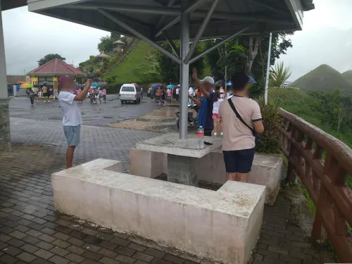
Chocolate Hills Adventure Park (CHAP)
Monument and historic site · 1.4 km
Balilihan-Hanopol-Batuan Road
Parks, trails and playgrounds3

Chocolate Hills Natural Monument
Hiking and trails · 5.8 km
Designated as Natural Monument at National level in 1988. It covers 140.89 km2.

Restaurants and cafes17





5 more on the map.
History
This interior town used to be a barrio of Bilar during the Spanish regime and was called Lindugon. During the early years of the American regime, this barrio was made into a municipality by Act No. 968 dated Oct 31, 1903 that provided the following: “The Municipality of Batuan shall consist of the territory of the barrio of Batuan in the present Municipality of Bilar, with the seat of the municipal government at the present barrio of Batuan.” (Acts of the Philippine Commission, Vol. XIV. Washington: Government Printing Office, 1904).
Batuan became a separate municipality through the efforts of local leaders such as Manuel Decasa, Alejandro Barril, and Victor Tiongson, who were even imprisoned for strongly advocating its separation from its mother town, Bilar. Despite this, they continued to pursue their goal after their release. The Municipality of Batuan was eventually established, initially comprising five barangays, namely Lindugon, Cambacay, Rosariohan, Janlud, and Cantigdas, and has since expanded to a total of fifteen barangays.
The early years of local administration saw its seat at Lindugon, now Poblacion Vieja. In 1911 however, the Municipal Hall, the seat of local government, was transferred to sitio Tinagacan for reasons of accessibility. Eventually, the parish church was also relocated to its present site at the Poblacion.
From the History section of Batuan, Bohol on Wikipedia, under CC BY-SA 4.0.
Where to stay17
Churches and places of worship9
Saint James The Apostle Parish
Church · Roman Catholic
Loay Interior Road, Batuan
Shopping5
Gas and EV charging6
Schools, colleges and libraries40
Healthcare7
Congressman Simeon G. Toribio Memorial Hospital
Hospital · 6.7 km
Loay Interior Road
Map of Batuan
115 places. The map loads OpenStreetMap tiles when you open it.
Getting there and nearby towns
Bohol-Panglao International Airport (TAG) is the nearest airport with scheduled flights listed in OpenStreetMap, 47 km away.
- Carmen 7 km northeast, about 7 min by car
- Sierra Bullones 16 km east, about 16 min by car
- Valencia 20 km south, about 20 min by car
- Loboc 20 km southwest, about 20 min by car
- Garcia Hernandez 24 km southeast, about 24 min by car
- Jagna 28 km southeast, about 28 min by car
- Inabanga 29 km north, about 29 min by car
- Tagbilaran City 35 km southwest, about 35 min by car
- Dauis 35 km southwest, about 35 min by car
- Guindulman 37 km east, about 37 min by car
Drive times are estimates from straight-line distance, not routes.
Local news
Headlines from INDB.
Reviews, tips and questions
Loading what members have shared...
Sources and licences
- GeoNames (CC BY 4.0): population, coordinates, regions and time zone
- Mapillary (see each image): photos
- OpenStreetMap contributors (ODbL 1.0): places, airports, map data
- Wikidata (CC0 1.0): elevation, founding date, time zone, website
- Wikimedia Commons (see each image): photos
- Wikipedia (CC BY-SA 4.0): overview and history text
Photo credits
- Batuan Bohol 1, P199, CC BY-SA 3.0
- Batuan, Central Visayas (8361228044), Sergey Norin from Moscow, Russia, CC BY 2.0
- Batuan, Central Visayas (8360778990), Sergey Norin from Moscow, Russia, CC BY 2.0
- Chocolate Hills overview, P199, CC BY-SA 3.0
- Chocolate Hills-bohol, Kleomarlo, CC BY-SA 4.0
- Chocolate Hills Bohol, P199, CC BY-SA 3.0
- Philippines - Bohol - Chocolate Hills, Didier Baertschiger, CC BY-SA 2.0
- Bohol's Chocolate Hills, rogel tura, CC0
- Chocolate hills under clouds, This photo was taken by Anton Zelenov . Please credit this with : Photo : Anton Zelenov in the immediate vicinity of the image. If you use one of my photos, please email me (account needed) or leave..., CC BY-SA 4.0
- The Chocolate Hills - panoramio, Tuderna, CC BY 3.0
- The Chocolate Hills - panoramio - Tuderna (1), Tuderna, CC BY 3.0
- The Chocolate Hills - panoramio - Tuderna, Tuderna, CC BY 3.0
- Chocolade Hills, Djuna Vaesen, CC BY-SA 4.0
- The Chocolate Hills - panoramio - Tuderna (2), Tuderna, CC BY 3.0
- Chocalate Hills, Bohol, Philippines, Marie Antoinette Calvez, CC BY-SA 4.0
- Bohol Chocolate Hills 1, Ed it12, CC BY-SA 4.0
- Chocolate Hills - panoramio (1), Qaalvin, CC BY 3.0
- Bohol Chocolate Hills 2, Ed it12, CC BY-SA 4.0
- Chocolate Hills - panoramio, Qaalvin, CC BY 3.0
- Bohol, Chocolate hills - panoramio, Павел Бондарчук, CC BY 3.0
- The amazing Choklate Hills - panoramio, matzi01, CC BY-SA 3.0
- THE CHOCOLATE HILLS, OfficialMetro, CC BY-SA 4.0
- Bohol - panoramio (1), Павел Бондарчук, CC BY 3.0
- The Chocolate Hills - panoramio - Tuderna (3), Tuderna, CC BY 3.0
- The Chocolate Hills in Bohol, rogel tura, CC0
- A Green Chocolate, Abundio Noel M. Libot, CC BY-SA 4.0
- Chocolate Hills II, Mark Levitin, CC BY-SA 4.0
- Chocolate Hills 1, Mark Levitin, CC BY-SA 4.0
- Bohol, Chocolate Hills, Andronette, CC BY-SA 4.0
- Chocolate Hills, Carmen, Bohol, Philippines, ChiyukiRen, CC BY-SA 4.0
- Chocolate Hills, Bohol (1), P.A.V. Mahusay, CC0
- Chocolate Hills, Bohol (2), P.A.V. Mahusay, CC0
- Cynocephalus volans 58339590, James Telford, CC BY 4.0
- Chocolate Hills from Sagbayan Peak, Francisco M. Pajares, Jr., CC BY-SA 4.0
- Bohol - Bohol1919, lumoplank, CC0
- Bohol - Bohol1932, lumoplank, CC0
- Bohol - Bohol1917, lumoplank, CC0
- View from chocolate hills - panoramio, Qaalvin, CC BY 3.0
- Carmen - panoramio, Robert Breivik, CC BY-SA 3.0
- Carmen, Bohol downtown area (pic 2), OxyLight, CC0
- Street-level photo, Vermut, CC BY-SA 4.0
- Street-level photo, Vermut, CC BY-SA 4.0


Page built November 7, 2026. Spotted a mistake? Tell us or suggest a place.