


Calinog, Philippines
Calinog is a town of 5,552 people in Western Visayas, Philippines, founded in 1763.
Why visit Calinog
Townapedia lists 14 museums and landmarks, 9 parks and trails, 70 places to eat, 11 places to stay and 3 attractions in and around town.
Highlights include Mount Palauan, Lapuz Lapuz Cave, Fork Junction and Bulabog Putian National Park.
Weather in Calinog
Forecast from MET Norway (CC BY 4.0). Full forecast
About Calinog
Calinog, officially known as the Municipality of Calinog (Kinaray-a: Banwa kang Calinog, Hiligaynon: Banwa sang Calinog, Tagalog: Bayan ng Calinog [pronounced Bayan nang Kah-lee-nog]), is a municipality in the province of Iloilo, Philippines. According to the 2024 census, it has a population of 63,896 people.
From the Wikipedia article Calinog (this version), under CC BY-SA 4.0.
Things to do3

Museums and landmarks14

Lapuz Lapuz Cave
Monument and historic site · 13.9 km
Cave and archaeological site in the Philippines
Fork Junction
Monument and historic site · 10.2 km
Purok 5 Lambunao-INCA Bypass Road
24/7
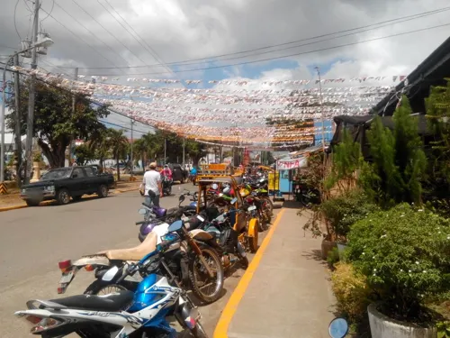
Perlas Monument
Monument and historic site · 8.3 km
F. Palmares Sr. Street, Passi
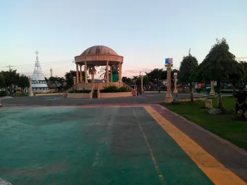
Ephraim's Prayer Garden (Cross of Ephraim)
Monument and historic site · 11.3 km
Highest point overlooking Brgy Santo Tomas ; a wooden cross and a prayer garden overlooking the community lit at night by Solar Light...
Simboryo ni Tomas Ford
Monument and historic site · 11.4 km
Ruins of an Old Mascuvado Sugar Mill Smokestack of the former estate owner still standing ,
World War II Memorial
Monument and historic site · 8.1 km
Railway bridge where Japanese beheadead many Passinhon
2 more on the map.
Parks, trails and playgrounds9



Restaurants and cafes70







58 more on the map.
History
Calinog is situated in the central part of Panay Island in the Philippines. By one local account, it was one of the areas where Datu Marikudo, the Ati chieftain, chose to settle after ceding the lowland regions of Panay to the Malay settlers in exchange for gold and other goods. This event, often dated to around the 13th century, is rooted in oral tradition and is referenced in the Maragtas, a semi-legendary account of the early history of Panay.
From the History section of Calinog on Wikipedia, under CC BY-SA 4.0.
Where to stay11
Balay ni Mayang Ermitanya
Motel and hotel · 11.7 km
Santo Tomas - Bitaogan Road, passi
Churches and places of worship42
7th Day Adventist Church
Church · Seventh Day Adventist · 10.5 km
Old Iloilo-Capiz Road
Immaculate Concepcion of Mary Parish Church
Church · Roman Catholic · 3.2 km
Rizal Street
Mary, Help of Christians Parish
Church · Roman Catholic · 10.9 km
Palabrica Street
Parish of Saint William Church
Church · Roman Catholic · 8.2 km
F. Palmares Sr. Street
Shopping23
Gas and EV charging14
Schools, colleges and libraries195
St. Therese Learnig Center
School · Roman Catholic · 11.0 km
Palabrica Street, San Enrique, Iloilo
Don Eugenio Ladrido Memorial Elementary School
School · 11.7 km
Ladrido Street, Lambunao
Healthcare31
Dr. Ricardo S. Provido Sr. Memorial Hospital
Hospital · 3.1 km
Old Iloilo-Capiz Road
Map of Calinog
250 places. The map loads OpenStreetMap tiles when you open it.
Getting there and nearby towns
Iloilo International Airport (ILO) is the nearest airport with scheduled flights listed in OpenStreetMap, 32 km away.
- Passi 8 km east, about 8 min by car
- San Enrique 11 km southeast, about 11 min by car
- Lambunao 12 km southwest, about 12 min by car
- Tapas 16 km north, about 16 min by car
- Dingle 17 km southeast, about 17 min by car
- Janiuay 20 km south, about 20 min by car
- Pototan 21 km south, about 21 min by car
- Dumarao 21 km northeast, about 21 min by car
- Cabatuan 28 km south, about 28 min by car
- Barotac Nuevo 29 km southeast, about 29 min by car
Drive times are estimates from straight-line distance, not routes.
Local news
Headlines from INDB.
Reviews, tips and questions
Loading what members have shared...
Sources and licences
- GeoNames (CC BY 4.0): population, coordinates, regions and time zone
- Mapillary (see each image): photos
- OpenStreetMap contributors (ODbL 1.0): places, airports, map data
- Wikidata (CC0 1.0): elevation, founding date, time zone, website, landmarks and historic places
- Wikimedia Commons (see each image): photos
- Wikipedia (CC BY-SA 4.0): overview and history text
Photo credits
- Bulabog entrance, BSrap, CC BY-SA 4.0
- Dueñas Church, Iloilo, Joelaldor, CC BY-SA 4.0
- Passi Church, Iloilo, Joelaldor, CC BY-SA 4.0
- ISS048-E-22842 - View of Earth, Earth Science and Remote Sensing Unit , Lyndon B. Johnson Space Center, Public domain
- Dueñas, Iloilo IMG 12022015 014444 PM, BSrap, CC BY-SA 4.0
- BINANOG DANCE, Pinkfabulous23, CC BY-SA 4.0
- ISS023-E-32557 - View of Earth, Earth Science and Remote Sensing Unit , Lyndon B. Johnson Space Center, Public domain
- ISS038-E-15730 - View of Earth, Earth Science and Remote Sensing Unit , Lyndon B. Johnson Space Center, Public domain
- Welcome arc of Passi City, Iloilo 20240218 143125, BSrap, CC BY 4.0
- Passi, Iloilo, 20220221, BSrap, CC BY-SA 4.0
- Passi, Iloilo 05-2022, BSrap, CC BY-SA 4.0
- Passi public market 20220625 114648, BSrap, CC BY-SA 4.0
- Jalaur River in Passi, Iloilo 05-2022, BSrap, CC BY-SA 4.0
- Passi parish church 09-12-20, BSrap, CC BY-SA 4.0
- Passi City, Iloilo 20230320 111948, BSrap, CC BY-SA 4.0
- Jalaur River passes through San Enrique, Iloilo 20230107 142750, BSrap, CC BY-SA 4.0
- Jalaur River passing through San Enrique, Iloilo20230107 142750, BSrap, CC BY-SA 4.0
- Dueñas, Iloilo IMG 12022015 124248 PM, BSrap, CC BY-SA 4.0
- US Navy 080701-N-5961C-011 Aviation Warfare Systems Operator 2nd Class Anthony Chavez, a native of San Bernardino, Calif., works with a soldier from the Armed forces of the Philippines to move relief..., U.S. Navy photo by Senior Chief Mass Communication Specialist Spike Call, Public domain
- ISS023-E-32558 - View of Earth, Earth Science and Remote Sensing Unit , Lyndon B. Johnson Space Center, Public domain
- ISS043-E-254413 - View of Earth, Earth Science and Remote Sensing Unit , Lyndon B. Johnson Space Center, Public domain
- ISS048-E-22841 - View of Earth, Earth Science and Remote Sensing Unit , Lyndon B. Johnson Space Center, Public domain
- ISS043-E-254414 - View of Earth, Earth Science and Remote Sensing Unit , Lyndon B. Johnson Space Center, Public domain
- Street-level photo, oslec, CC BY-SA 4.0
- Street-level photo, oslec, CC BY-SA 4.0
- Street-level photo, oslec, CC BY-SA 4.0


Page built November 7, 2026. Spotted a mistake? Tell us or suggest a place.