
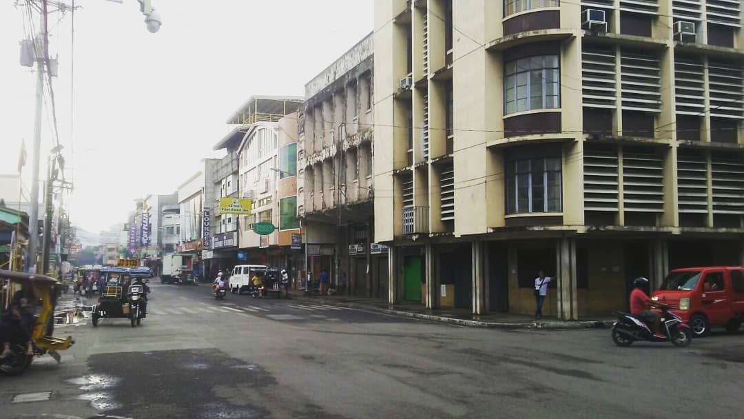


Dipolog, Philippines
Dipolog is a town of 93,549 people in Zamboanga Peninsula, Philippines, founded in July 1, 1913.
Why visit Dipolog
Townapedia lists 13 museums and landmarks, 7 parks and trails, 135 places to eat, 54 places to stay and 3 attractions in and around town.
Highlights include Jose Rizal Memorial Protected Landscape and Jose Rizal's Farm.
Weather in Dipolog
Forecast from MET Norway (CC BY 4.0). Full forecast
About Dipolog
Dipolog ([diˈpɔʔlɔg]), officially the City of Dipolog, is a component city and capital of the province of Zamboanga del Norte, Philippines. According to the 2024 census, it has a population of 136,528 people making it the most populous in the province.
From the Wikipedia article Dipolog (this version), under CC BY-SA 4.0.
Travel tips from other travellers: Dipolog on Wikivoyage (CC BY-SA 4.0).
Things to do3



Museums and landmarks13


Jose Rizal Memorial Protected Landscape
Monument and historic site · 14.4 km
Memorial Landscape of José Rizal

Jose Rizal Monument
Monument and historic site · 8.3 km
The Statue of Rizal at JRMSU

1 more on the map.
Parks, trails and playgrounds7



Restaurants and cafes135

Bistro Chasah
Cafe · Coffee Shop · 2.0 km
Tomas Claudio Street, Dipolog City
Tu-Su 10:00-20:00, Mo off
Galley Cafe
Cafe · Coffee Shop · 2.2 km
Arellano Street, Dipolog City
Tu-Su 09:00-22:00
Uncle Brew Prime
Cafe · Coffee Shop, Bubble Tea · 2.5 km
Padre Jose A. Ramon Street, Dipolog City
Mo-Fr 09:00-22:00, Su 07:00-22:00, Sa off

Yoshidon Cafe
Restaurant · Ramen, Japanese · 2.6 km
Dipolog-Polanco Road, Dipolog City
Mo-Th 11:00-21:00; Fr-Su 11:00-22:00
Ikkokuya Ramen Bistro
Restaurant · Ramen · 2.6 km
Dipolog-Polanco Road, Dipolog City
Mo 16:00-22:00; Tu-Th,Su 11:00-22:00; Fr-Sa 11:00-23:00

Heritage Bakery
Bakery · 2.6 km
Dipolog-Polanco Road, Dipolog City
Mo-Su 06:00-22:00
Baba Ayman's Satti
Restaurant · Regional, Filipino · 3.7 km
Felipe Lacaya Street Extension
123 more on the map.
Where to stay54
Filipinas Hostel
Motel and hotel · 2.5 km
Padre Jose A. Ramon Street, Dipolog City
AFP Transient Facility Dipolog
Motel and hotel · 3.3 km
General John J. Pershing Highway, Dipolog City
Churches and places of worship34
Medalla Milagrosa Chapel
Church · Roman Catholic · 1.5 km
One Heart Road, Dipolog City
Cathedral of Our Lady of the Most Holy Rosary
Church · Roman Catholic · 2.4 km
Padre Ramon Street, Dipolog City
Holy Family - Bagakayan Chapel
Church · Roman Catholic · 3.2 km
Eugenio R. Margate Road, Dipolog City
Kingdom Hall of Jehovah's Witnesses
Church · Jehovahs Witness · 2.7 km
General John J. Pershing Highway, Dipolog City
Lokal ng Dipolog City, Iglesia ni Cristo
Church · Iglesia Ni Cristo · 1.7 km
Magsaysay street
Our Lady of Fatima Parish
Church · Roman Catholic
Dipolog-Oroquieta Road, Dipolog
Our Lady of Perpetual Help Parish
Church · Roman Catholic · 6.0 km
Dipolog-Oroquieta Road, Dipolog
Parish of Saint Roch
Church · Roman Catholic · 6.2 km
Sicayab Circumferential Road, Dipolog City
Saint Anthony De Padua Chapel
Church · Roman Catholic · 10.3 km
Dipolog-Sindangan-Liloy Road, Katipunan
Saint Anthony of Padua Parish, Gulayon
Church · Roman Catholic · 3.5 km
Polanco - Piñan Road, Dipolog City
Saint Isidore the Laborer Chapel
Church · Roman Catholic · 2.4 km
Banicapt Road, Dipolog
Shopping37
Atheena's Japanese Korean Mart
Grocery · 2.6 km
Dipolog-Polanco Road, Dipolog City
Gas and EV charging41
Schools, colleges and libraries128
Jose Rizal Memorial State University-Katipunan
School · 8.3 km
Dipolog-Sindangan-Liloy Road, Katipunan
Saint Vincent's College
School · Roman Catholic · 2.4 km
Padre Jose A. Ramon Street, Dipolog City
Zamboanga Norte National High School
School · 2.3 km
Cirilo Sorronda Road, Dipolog City
Cor Jesu Seminary
School · Roman Catholic · 1.2 km
Padre Patangan Road, Dipolog City
Saint Mary's Academy
School · Catholic · 2.3 km
Padre Jose A. Ramon Street, Dipolog City
Healthcare40
Corazon C. Aquino Hospital
Hospital · 3.0 km
Doctor Santiago Calo Road, Dipolog
Dr. Jose Rizal Memorial Hospital
Hospital · 12.0 km
Dapitan Park National Road, Dapitan City
Zamboanga Del Norte Medical Center
Hospital · 4.5 km
Dipolog-Oroquieta Road, Dipolog
The AGAPE Health Care Center
Clinic and pharmacy · 2.1 km
35 Felicisimo Herrera Street, Dipolog City
A4M Pharmacy and Convenience Store
Clinic and pharmacy · 2.1 km
Tomas Claudio Street, Dipolog City
Dipolog Cherry Pharmacy
Clinic and pharmacy · 2.4 km
Felipe Lacaya Street, Dipolog
Dipolog City Dialysis Center
Clinic and pharmacy · 2.2 km
Padre Jose A. Ramon Street, Dipolog City
Map of Dipolog
250 places. The map loads OpenStreetMap tiles when you open it.
Getting there and nearby towns
Dipolog Airport (DPL) is the nearest airport with scheduled flights listed in OpenStreetMap, 4 km away.
- Dapitan 14 km northeast, about 14 min by car
- Oroquieta 52 km east, about 52 min by car
- Dauin 70 km north, about 1 h 15 min by car
- Lazi 71 km northeast, about 1 h 15 min by car
- Ozamiz City 73 km southeast, about 1 h 15 min by car
- Tangub 72 km southeast, about 1 h 15 min by car
- Siquijor 75 km north, about 1 h 15 min by car
- Tubod 76 km southeast, about 1 h 15 min by car
- Dumaguete 82 km north, about 1 h 15 min by car
- Pagadian 83 km south, about 1 h 30 min by car
Drive times are estimates from straight-line distance, not routes.
Local news
Headlines from INDB.
Reviews, tips and questions
Loading what members have shared...
Sources and licences
- GeoNames (CC BY 4.0): population, coordinates, regions and time zone
- OpenStreetMap contributors (ODbL 1.0): places, airports, map data
- Wikidata (CC0 1.0): elevation, founding date, time zone, website, landmarks and historic places
- Wikimedia Commons (see each image): photos
- Wikipedia (CC BY-SA 4.0): overview and history text
Photo credits
- Downtown Dipolog early morning (2019), Xander Wu, CC BY-SA 4.0
- Dipolog Cathedral (2016), Xander Wu, CC BY-SA 4.0
- Zamboanga Del Norte National HS (Sorronda, Dipolog, Zamboanga Del Norte; 10-17-2023), Patrickroque01, CC BY-SA 4.0
- Blessing & Inauguration of Dipolog Port Terminal (1), Zamboanga del Norte Provincial News Network, Public domain
- Dipolog coast and bay monochrome - Flickr, R924 from USA, CC BY 2.0
- Explore Dipolog Landmark, Briarbaron1998, CC BY-SA 4.0
- Blessing & Inauguration of Dipolog Port Terminal (2), Zamboanga del Norte Provincial News Network, Public domain
- Dipolog City Land Transport Terminal, Dipolog City Government, Public domain
- Lee Plaza Dipolog under construction (2007), Placelover, Public domain
- Zamboanga del Norte, Dipolog, Miputak, Quezon Avenue (2017-02-16), Xander Wu, CC BY-SA 4.0
- McDonald's Dipolog (2016 Grand Opening), Xander Wu, CC BY-SA 4.0
- Dipolog Santa Cruz Marker (Rizal Avenue-Martinez, Dipolog, Zamboanga Del Norte; 10-17-2023), Patrickroque01, CC BY-SA 4.0
- Dipolog Central, Rizal Avenue-Lacaya (Dipolog, Zamboanga Del Norte; 10-17-2023), Patrickroque01, CC BY-SA 4.0
- KFC Dipolog Opening Day 2022-1114, Dipolog City Government, Public domain
- Dipolog Magsaysay Park (Herrera, Dipolog, Zamboanga Del Norte; 10-17-2023), Patrickroque01, CC BY-SA 4.0
- Dipolog Central, Rizal Avenue (Dipolog, Zamboanga Del Norte; 10-17-2023), Patrickroque01, CC BY-SA 4.0
- Dipolog Rotonda, Marwan Khan, CC BY-SA 4.0
- Rice harvesting in Dipolog - Flickr, Ronnie from Yahoo, CC BY 2.0
- Dipolog Airport Access Road, Marwan Khan, CC BY-SA 3.0
- Dipolog Airport Terminal 17Dec2019, RFNirmala, CC0
- Jose Rizal Shrine, Dapitan, Zamboanga del Norte, Ric Canizares, CC BY-SA 3.0
- Corazon C. Aquino Hospital, 2020, Freger Reyes/Dipolog City Government, Public domain
- Dr. Jose Rizal Memorial Hospital NHCP Marker, Leocvlauzon, CC BY-SA 4.0
- ABCollege GP Building, Xander Wu, CC BY-SA 4.0
- Zamboanga del Norte Medical Center, Placelover at English Wikipedia, Public domain
- ABCollege GP Building 2016, Xander Wu, CC BY 4.0
- STA. CRUZ - (Punta Corro), Dastreetfilmer, CC BY-SA 3.0
- "ANGELS AND CROTONS" A SOLO ART EXHIBIT OF MEINARDO Y. VELASCO 001, Dipolog City Government, Public domain
- Parked Cessna 150, Carl homer d, CC BY 4.0
- BATA NGA DUNA’Y SAKIT TYPE 1 DIABETES GITABANGAN SA NGO 002, Dipolog City Government, Public domain
- PSHS-ZRC 2nd Commencement Exercises (25), Dipolog City Government, Public domain
- PSHS-ZRC 2nd Commencement Exercises (18), Dipolog City Government, Public domain
- PSHS-ZRC 2nd Commencement Exercises (15), Dipolog City Government, Public domain
- PSHS-ZRC 2nd Commencement Exercises (17), Dipolog City Government, Public domain
- Oct 15 Story 3 Barra Bridge (2), Department of Public Works and Highways (Philippines), Public domain
- CCAH-Divine Mercy Chapel exterior, Xander Wu, CC BY-SA 4.0
- CCAH-Divine Mercy Chapel plaque, Xander Wu, CC BY-SA 4.0
- CCAH-Divine Mercy Chapel interior, Xander Wu, CC BY-SA 4.0
- Polanco Poblacion, Marwan Khan, CC BY-SA 3.0
- Polanco Municipal Hall 2020, Local Government Unit of Polanco, Zamboanga del Norte, Public domain


Page built November 7, 2026. Spotted a mistake? Tell us or suggest a place.