
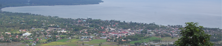

Gingoog, Philippines
Gingoog is a city of 138,895 people in Northern Mindanao, Philippines.
Why visit Gingoog
Townapedia lists 4 museums and landmarks, 5 parks and trails, 12 places to eat, 7 places to stay and 12 attractions in and around town.
Highlights include Macahambus Cave.
Weather in Gingoog
Forecast from MET Norway (CC BY 4.0). Full forecast
About Gingoog
Gingoog (Binukid pronunciation: ['hiŋuʔog] HEE-ngu-og), officially the City of Gingoog (Cebuano: Dakbayan sa Hingoog; Filipino: Lungsod ng Gingoog), is a component city in the province of Misamis Oriental, Philippines. According to the 2024 census, it has a population of 138,895 people.
From the Wikipedia article Gingoog (this version), under CC BY-SA 4.0.
Travel tips from other travellers: Gingoog on Wikivoyage (CC BY-SA 4.0).
Things to do12


Macahambus Cave
Monument and historic site · 14.0 km
Scenic cave in the Philippines



Museums and landmarks4

Parks, trails and playgrounds5

Da Grove at Highway 955
Park · 14.8 km
Civoleg, Brgy. Lunotan Gingoog-Claveria-Villanueva Road, Gingoog City


Restaurants and cafes12

Guzmana Avenue
Restaurant · Regional, Coffee Shop · 14.3 km
Sitio Civoleg Brgy. Lunotan, Gingoog City

Ice Cream Station No. 1
Ice cream
Rizal Street
Mo-Su 14:00-21:00
Civoleg Hill Top Garden Hub
Restaurant · Filipino, Coffee Shop · 14.0 km


Vege-To-Go
Fast food · 1.1 km
Mo-Th,Su 09:00-18:00; Fr 09:00-15:00; Sa off
History
The term Gingoog originally came from the word "Hingoog", which means "Goodluck", from a Lumad tribe of Manobo who settled in the area. The word implies good fortune, thus Gingoog means the "City of Good Luck". The natives of this place are the ones with the family names of "Gingco", and "Gingoyon".
Gingoog was founded as a mission by Spanish missionaries in 1750. It was one of the oldest localities in Misamis Oriental Province, older than the province's capital and economic hub, Cagayan de Oro which was founded in 1871. During the late Spanish colonial period, influential families of Spanish descent settled and governed the area. They built large, two-story wooden ancestral houses in the traditional Spanish-colonial style, which remain preserved in the old downtown (Poblacion) area today. Among them, Don Manuel Lugod became the town's first Spanish language teacher and a prominent local pioneer.
The territory of then-independent Gingoog was made part of Talisayan for a while, since the passage of Act No. 951, issued by the Philippine Commission on October 21, 1903, which reduced the number of municipalities in the then-undivided Misamis province from 24 to 10, until becoming the first former municipality to be reconstituted thereafter through Act No. 1618, enacted on March 20, 1907 and took effect on August 10.
From the History section of Gingoog on Wikipedia, under CC BY-SA 4.0.
Where to stay7
Churches and places of worship21
Iglesia ni Cristo
Church · Iglesia Ni Cristo · 10.4 km
Butuan-Cagayan de Oro-Iligan Road, Gingoog
Lokal ng Medina, Iglesia ni Cristo
Church · Iglesia Ni Cristo · 12.3 km
Ebarle Street, Medina
Panaad sa Samay
Church · Roman Catholic · 9.4 km
Brgy. Samay Gingoog-Claveria-Villanueva Road, Gingoog City
Seventh Day Adventist Church
Church · Seventh Day Adventist · 2.2 km
J. Z. Mercado Avenue, Gingoog City
Seventh Day Adventist Church
Church · Seventh Day Adventist · 10.7 km
Butuan-Cagayan de Oro-Iligan Road
The Church of Jesus Christ of Latter-day Saints
Church · Mormon · 9.7 km
Butuan-Cagayan de Oro-Iligan Road, Gingoog
United Pentecostal Church
Church · Pentecostal · 0.8 km
Kiunisala Street, Gingoog City
Shopping4
Gaisano Grand Mall Gingoog
Shopping center · 1.5 km
J. J. Ganaban Avenue, Gingoog
Gas and EV charging10
Schools, colleges and libraries108
Don Gregorio Pelaez Memorial National High School
School · 10.1 km
Butuan-Cagayan de Oro-Iligan Road, Medina
Don Restituto Baol Central School
School · 0.7 km
J. J. Ganaban Avenue, Gingoog City
Doña J. Pelaez Reyes Elementary School
School · 8.6 km
National Highway, Gingoog City
Esik Campilan Elementary School
School · 12.8 km
Secondary National Highway, Gingoog City
Gingoog City Comprehensive National High School
School · 0.6 km
J. J. Ganaban Avenue, Gingoog City
Lunotan Elementary School
School · 11.5 km
Gingoog-Claveria-Villanueva Road, Gingoog City
Maanas Elementary School
School · 10.2 km
Butuan-Cagayan de Oro-Iligan Road, Medina
Healthcare6
Gingoog Sanitarium and Hospital
Hospital · Seventh Day Adventist · 0.9 km
23 C. Bagaipo Street, Gingoog City
Misamis Oriental Provincial Hospital - Gingoog City
Hospital · 1.4 km
F. Dugenio Street, Gingoog
Map of Gingoog
189 places. The map loads OpenStreetMap tiles when you open it.
Getting there and nearby towns
Bancasi Airport (BXU) is the nearest airport with scheduled flights listed in OpenStreetMap, 44 km away.
- Claveria 33 km southwest, about 33 min by car
- Buenavista 38 km northeast, about 38 min by car
- Balingasag 37 km west, about 37 min by car
- Malitbog 40 km southwest, about 40 min by car
- Villanueva 44 km southwest, about 44 min by car
- Butuan 51 km east, about 51 min by car
- Tagoloan 50 km southwest, about 50 min by car
- Magallanes 51 km northeast, about 51 min by car
- Manolo Fortich 57 km southwest, about 57 min by car
- Cagayan de Oro 63 km southwest, about 1 h by car
Drive times are estimates from straight-line distance, not routes.
Local news
Headlines from INDB.
Reviews, tips and questions
Loading what members have shared...
Sources and licences
- GeoNames (CC BY 4.0): population, coordinates, regions and time zone
- OpenStreetMap contributors (ODbL 1.0): places, airports, map data
- Wikidata (CC0 1.0): elevation, founding date, time zone, website, landmarks and historic places
- Wikimedia Commons (see each image): photos
- Wikipedia (CC BY-SA 4.0): overview and history text
Photo credits
- Skyline View Gingoog, Gingoog City Local Government Unit, Public domain
- LABANAN SA BUROL NG MAKAHAMBUS, Bap Flores, CC0
Page built November 8, 2026. Spotted a mistake? Tell us or suggest a place.