




Why visit Guiuan
Townapedia lists 4 museums and landmarks, 7 parks and trails, 11 places to eat, 4 places to stay and 2 attractions in and around town.
Highlights include Samar and United Nations Evacuation Center: Tubabao, Guiuan, Silangang Samar.
Weather in Guiuan
Forecast from MET Norway (CC BY 4.0). Full forecast
About Guiuan
Guiuan ([ˈgiˌwan] ; Waray: Bungto han Guiuan, Filipino: Bayan ng Guiuan), officially the Municipality of Guiuan, is a municipality in the province of Eastern Samar, Philippines. It constitutes the southeastern extremity of Samar Island and some adjacent islands, surrounded by Leyte Gulf and the Philippine Sea (which a marginal sea of the Pacific Ocean), two major bodies of water that makes the town the surfing capital of the Visayas. According to the 2024 census, it has a population of 52,749 people, making it the most populous municipality in Eastern Samar (followed by Dolores) and the second most populous administrative division in the entire province after the capital city Borongan.
From the Wikipedia article Guiuan (this version), under CC BY-SA 4.0.
Travel tips from other travellers: Guiuan on Wikivoyage (CC BY-SA 4.0).
Things to do2


Museums and landmarks4

United Nations Evacuation Center: Tubabao, Guiuan, Silangang Samar
Monument and historic site · 3.4 km
Parks, trails and playgrounds7




Restaurants and cafes11





History
Guiuan is widely known for two significant events in history 423 years apart. In 1521, Ferdinand Magellan, first European to set foot on Philippine soil, landed in Homonhon, now part of Guiuan. In 1944, the American Forces landed on the island of Suluan where they fought their first battle in the Philippine territory three days before Gen. Douglas MacArthur stormed the beaches of Leyte. The Americans built a military base for its torpedo boats, warships, bombers and fighter planes. The base was the biggest American supply base in the Pacific during the war. About 100,000 American servicemen were stationed in Guiuan and nearby towns.
The Spanish priest and historian Juan José Delgado was stationed in Guiuan in the 18th century. In his book Biblioteca Histórica Filipina: Historia general sacro-profana, política y natural de las islas del poniente llamadas Filipinas (1751), he recorded the old name of the region as "Guiguan." He describes it as a thin stretch of land on the southern tip of Samar. He also describes the nearby islands of "Omonhon" (Homonhon), "Soloan" (Suluan), Tubabao, "Manicaui" (Manicani), and other small islets and settlements.
From the History section of Guiuan on Wikipedia, under CC BY-SA 4.0.
Where to stay4
Churches and places of worship49
Shopping10
Gas and EV charging6
Schools, colleges and libraries58
Immaculate Conception School of Guiuan
School · Roman Catholic
Guimbaolibot Avenue
Eastern Samar State University Guiuan Campus
School · 1.2 km
Guimbaolibot Avenue
Healthcare21
Map of Guiuan
172 places. The map loads OpenStreetMap tiles when you open it.
Getting there and nearby towns
Daniel Z. Romualdez Airport (TAC) is the nearest airport with scheduled flights listed in OpenStreetMap, 79 km away.
- Salcedo 14 km northwest, about 14 min by car
- Sulangan 15 km southeast, about 15 min by car
- Quinapundan 26 km northwest, about 26 min by car
- General MacArthur 31 km northwest, about 31 min by car
- Giporlos 31 km west, about 31 min by car
- Hernani 35 km north, about 35 min by car
- Balangiga 38 km west, about 38 min by car
- Tanauan 78 km west, about 1 h 15 min by car
- Palo 81 km west, about 1 h 15 min by car
- Tacloban 82 km west, about 1 h 15 min by car
Drive times are estimates from straight-line distance, not routes.
Local news
Headlines from INDB.
Reviews, tips and questions
Loading what members have shared...
Sources and licences
- GeoNames (CC BY 4.0): population, coordinates, regions and time zone
- OpenStreetMap contributors (ODbL 1.0): places, airports, map data
- Wikidata (CC0 1.0): elevation, founding date, time zone, website
- Wikimedia Commons (see each image): photos
- Wikipedia (CC BY-SA 4.0): overview and history text
Photo credits
- Guiuan montage, Nairb.Idi9, CC BY-SA 4.0
- Guiuan Church, Angelo Juan Ramos from Makati City, Philippines, CC BY 2.0
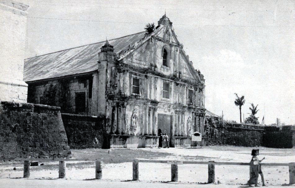
- Immaculate Conception Church in Guiuan, Eastern Samar, in 1945, U.S. Navy, Public domain
- Guiuan East Central Elementary School flooded due to Tropical Storm Megi (April 10, 2022), Nairb.Idi9, CC BY-SA 4.0
- View of the twilight over Leyte Gulf from the Guiuan Terminal in 2022, Nairb.Idi9, CC BY-SA 4.0
- View of the Leyte Gulf and Manicani Island from the Guiuan Terminal in April 2022 (1), Nairb.Idi9, CC BY-SA 4.0
- Homonhon Island, Guiuan, Eastern Samar at sunset, Nairb.Idi9, CC BY-SA 4.0
- Manicani Island, Guiuan, Eastern Samar at sunset, Nairb.Idi9, CC BY-SA 4.0
- Small Lagoon Tubabao Island Guiuan, Angelo Juan Ramos from Makati City, Philippines, CC BY 2.0
- The DOST-PAGASA Guiuan Weather Station in 2022, Nairb.Idi9, CC BY-SA 4.0
- View of Calicoan Island and the Philippine Sea from the DOST-PAGASA Guiuan Weather Station in 2022, Nairb.Idi9, CC BY-SA 4.0
- Book of Mormon English Missionary Edition Soft Cover, photo by user:Ricardo630 , cover by The Church of Jesus Christ of Latter-day Saints which is {{PD-ineligible}}, Public domain
- The Immaculate Conception Church of Guiuan in 2019, Nairb.Idi9, CC BY-SA 4.0
- Guiuan Town Plaza in 2019, Nairb.Idi9, CC BY-SA 4.0
- The Immaculate Conception Church of Guiuan in April 2022, Nairb.Idi9, CC BY-SA 4.0


Page built November 7, 2026. Spotted a mistake? Tell us or suggest a place.