


Tacloban, Philippines
Tacloban is a city of 259,353 people in Eastern Visayas, Philippines, founded in February 26, 1830.
Why visit Tacloban
Townapedia lists 14 museums and landmarks, 16 parks and trails, 241 places to eat, 61 places to stay and 4 attractions in and around town.
Highlights include San Juanico Bridge, Santo Niño Shrine and Heritage Museum, Yolanda Shipwreck Memorial Park and MacArthur Landing Memorial National Park.
Weather in Tacloban
Forecast from MET Norway (CC BY 4.0). Full forecast
About Tacloban
Tacloban ( tak-LOH-ban; Tagalog pronunciation: [tɐkˈloban]), officially the City of Tacloban (Waray: Syudad han Tacloban; Filipino: Lungsod ng Tacloban), is a highly urbanized city in the Eastern Visayas region of the Philippines. According to the 2024 census, it has a population of 259,353, making it the most populous city in Eastern Visayas. The city is located 360 miles (580 km) southeast of Manila.
From the Wikipedia article Tacloban (this version), under CC BY-SA 4.0.
Travel tips from other travellers: Tacloban on Wikivoyage (CC BY-SA 4.0).
Things to do4
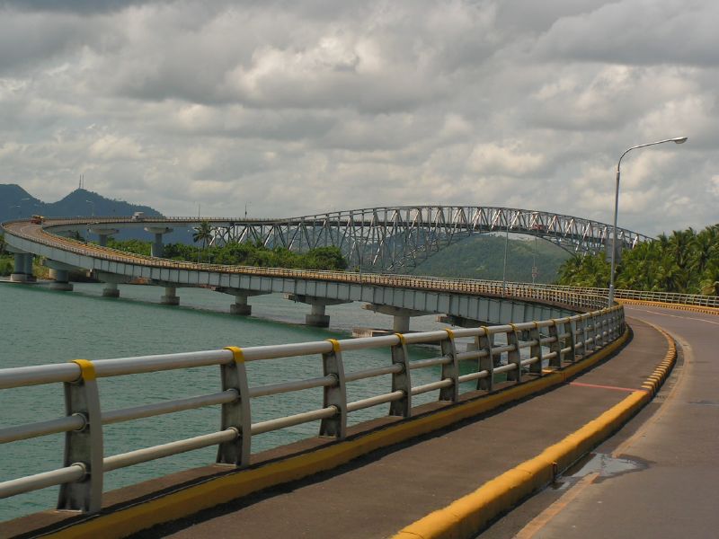
San Juanico Bridge
Bridge · 7.5 km
Long truss bridge in the Philippines


Museums and landmarks14

Santo Niño Shrine and Heritage Museum
Museum · 0.9 km
Museum in Tacloban, Philippines


Yolanda Shipwreck Memorial Park
Monument and historic site · 1.8 km
Memorial park and monument in Philippines


2 more on the map.
Parks, trails and playgrounds16

MacArthur Landing Memorial National Park
Park · 7.9 km
National park in the Philippines

4 more on the map.
Restaurants and cafes241

Cafe Esquinita
Restaurant · Filipino, Asian, Coffee Shop, Bubble Tea, Frappe
Santo Niño Street, Tacloban
Mo-Sa 09:00-20:00

Royal Kitchen
Restaurant · Chinese Food
Justice Romualdez Street, Tacloban
Mo-Fr 08:00-21:00
JO's Milagrina Tacloban
Restaurant · Chicken
P. Burgos Street, Tacloban
11:00-21:00
KyuKyu Ramen 99
Restaurant · Japanese, Noodle, Pasta, Ramen · 0.6 km
Justice Romualdez Street
Mo-Su 09:00-21:00
229 more on the map.
History
Originally named Kankabatok, the name change came about in this manner: Kankabatok was a favorite haunt of fishermen. They would use a bamboo contraption called a "taklub" to catch crabs, shrimps or fish.
The 1800s census by Manuel Buzeta recorded 2,290 native families in Tacloban and they co-existed with 11 Spanish-Filipino families.
The capital of Leyte was transferred from one town to another with Tacloban as the last on February 26, 1830. The decision to make Tacloban the capital was based on the following reasons: 1) ideal location of the port and 2) well-sheltered and adequate facilities. On June 20, 1952, Tacloban was proclaimed a chartered city by virtue of Republic Act No. 760.
In November 1912, a typhoon swept through the central Philippines and "practically destroyed" Tacloban. In Tacloban and Capiz on the island of Panay, the death toll was 15,000, half the population of those cities at the time.
From the History section of Tacloban on Wikipedia, under CC BY-SA 4.0.
Where to stay61
Churches and places of worship17
Light And Life Community United Methodist Church
Church · Methodist · 2.0 km
4th Street, Tacloban City
Seventh Day Adventist Church
Church · Seventh Day Adventist · 1.9 km
Esperas Avenue
The Church of Jesus Christ of Latter-day Saints
Church · Mormon
P. Burgos Street, Tacloban
Shopping69
Gas and EV charging9
Schools, colleges and libraries47
Asian Development Foundation College (ADFC Main Campus)
School
262 P. Burgos Street, Tacloban
Cirilo Roy Montejo National Night High School
School
Corner P. Paterno Street 7 T. Claudio Street, Tacloban
Healthcare44
Southstar Drug
Clinic and pharmacy · 2.0 km
President Sergio Osmeña Avenue, Tacloban
Eastern Visayas Medical Center - Magsaysay
Hospital · 0.9 km
Magsaysay Boulevard, Tacloban City
Map of Tacloban
250 places. The map loads OpenStreetMap tiles when you open it.
Getting there and nearby towns
Daniel Z. Romualdez Airport (TAC) is the nearest airport with scheduled flights listed in OpenStreetMap, 3 km away.
- Pawing 7 km south, about 7 min by car
- Basey 8 km northeast, about 8 min by car
- Palo 10 km south, about 10 min by car
- Tanauan 15 km south, about 15 min by car
- Dagami 23 km southwest, about 23 min by car
- Santa Rita 24 km north, about 24 min by car
- Barugo 30 km west, about 30 min by car
- Burauen 32 km south, about 32 min by car
- Dulag 32 km south, about 32 min by car
- Carigara 36 km west, about 36 min by car
Drive times are estimates from straight-line distance, not routes.
Local news
Headlines from INDB.
Reviews, tips and questions
Loading what members have shared...
Sources and licences
- GeoNames (CC BY 4.0): population, coordinates, regions and time zone
- OpenStreetMap contributors (ODbL 1.0): places, airports, map data
- Wikidata (CC0 1.0): elevation, founding date, time zone, website, landmarks and historic places
- Wikimedia Commons (see each image): photos
- Wikipedia (CC BY-SA 4.0): overview and history text
Photo credits
- Tacloban, Philippines, Vyacheslav Argenberg, CC BY 4.0
- Altocumulus cloud over Tacloban City, Philippines 1, Nairb.Idi9, CC BY-SA 4.0
- Altocumulus cloud over Tacloban City, Philippines 3, Nairb.Idi9, CC BY-SA 4.0
- Cumulus cloud over Tacloban City, Philippines 2, Nairb.Idi9, CC BY-SA 4.0
- Altocumulus cloud over Tacloban City, Philippines 2, Nairb.Idi9, CC BY-SA 4.0
- Cirrus clouds over Tacloban City, Philippines 6, Nairb.Idi9, CC BY-SA 4.0
- 2019 Waray Wikipedia Edit-a-thon in Tacloban 51, JinJian, CC BY-SA 4.0
- Santo Nino Church Tacloban altar (002) 2023-11-19, LMP 2001, CC BY-SA 4.0
- Santo Nino Church Tacloban nave (002) 2023-11-19, LMP 2001, CC BY-SA 4.0
- Santo Nino Church Tacloban altar (001) 2023-11-19, LMP 2001, CC BY-SA 4.0
- Santo Nino Church Tacloban (002) 2023-11-19, LMP 2001, CC BY-SA 4.0
- Santo Nino Church Tacloban nave (001) 2023-11-19, LMP 2001, CC BY-SA 4.0
- Sto. Niño Church of Tacloban, JinJian, CC BY-SA 4.0
- Santo Niño Church of Tacloban, JinJian, CC BY-SA 3.0
- 2018 Waray Wikipedia Edit-a-thon in Tacloban 4, JinJian, CC BY-SA 4.0
- TACLOBANSTORE1, TheNuggeteer, CC BY-SA 4.0
- 2016 Waray Edit-a-thon in Tacloban 37, JinJian, CC BY-SA 4.0
- Tacloban City Hall 2016, JinJian, CC BY-SA 4.0
- TACLOBANMCDO, TheNuggeteer, CC BY-SA 4.0
- Nimbostratus cloud over Tacloban City, Philippines 2, Nairb.Idi9, CC BY-SA 4.0
- Nimbostratus cloud over Tacloban City, Philippines 1, Nairb.Idi9, CC BY-SA 4.0
- Peace commemoration statue in the Kanfuraw Hill, Tacloban03, Akitoshi Iio, CC BY-SA 3.0
- Peace commemoration statue in the Kanfuraw Hill, Tacloban02, Akitoshi Iio, CC BY-SA 3.0
- Peace commemoration statue in the Kanfuraw Hill, Tacloban04, Akitoshi Iio, CC BY-SA 3.0
- Peace commemoration statue in the Kanfuraw Hill, Tacloban01, Akitoshi Iio, CC BY-SA 3.0
- Madonna of Japan in the Kanfuraw Hill, Tacloban01, Akitoshi Iio, CC BY-SA 3.0
- Cirrus clouds over Tacloban City, Philippines 2, Nairb.Idi9, CC BY-SA 4.0
- Cirrus clouds over Tacloban City, Philippines 1, Nairb.Idi9, CC BY-SA 4.0
- Cirrus clouds over Tacloban City, Philippines 4, Nairb.Idi9, CC BY-SA 4.0
- Cirrus clouds over Tacloban City, Philippines 5, Nairb.Idi9, CC BY-SA 4.0
- Cirrus clouds over Tacloban City, Philippines 3, Nairb.Idi9, CC BY-SA 4.0
- Cumulus cloud over Tacloban City, Philippines 3, Nairb.Idi9, CC BY-SA 4.0
- 2016 Waray Edit-a-thon in Tacloban 36, JinJian, CC BY-SA 4.0
- Stratocumulus cloud over Tacloban City, Philippines 3, Nairb.Idi9, CC BY-SA 4.0
- Stratocumulus cloud over Tacloban City, Philippines 1, Nairb.Idi9, CC BY-SA 4.0
- Leyte Provincial Capitol in Tacloban, Philippines, in 1945, U.S. Navy, Public domain
- San Juanico Bridge, byron alcantara from Fredon, United States, Public domain
- Santo Niño Shrine and Heritage Museum, Bap Flores, CC0
- Palo Cathedral 01, Jojit Ballesteros, CC BY 4.0
- MV Eva Jocelyn Shrine (Anibong, Tacloban, Leyte; 04-29-2023), Patrickroque01, CC BY-SA 4.0


Page built November 8, 2026. Spotted a mistake? Tell us or suggest a place.