


Sagbayan, Philippines
Sagbayan is a town of 4,934 people in Central Visayas, Philippines, founded in February 9, 1949.
Why visit Sagbayan
Townapedia lists 1 museum or landmark, 2 parks and trails, 3 places to eat, 4 places to stay and 4 attractions in and around town.
Weather in Sagbayan
Forecast from MET Norway (CC BY 4.0). Full forecast
About Sagbayan
Sagbayan, officially the Municipality of Sagbayan (Cebuano: Munisipyo sa Sagbayan; Tagalog: Bayan ng Sagbayan), is a municipality in the province of Bohol, Philippines. According to the 2024 census, it has a population of 25,329 people.
From the Wikipedia article Sagbayan (this version), under CC BY-SA 4.0.
Things to do4




Museums and landmarks1

Parks, trails and playgrounds2


Restaurants and cafes3

Nanay's Lugawan at iba pa
Restaurant · 4.0 km
Sagbayan-Bacani Road
Mo-Sa 06:30-20:00

History
Sagbayan was formerly part of the surrounding municipalities of Clarin, Inabanga, Carmen, and Balilihan. It was created into a separate town through Executive Order No. 204 of President Elpidio Quirino on February 9, 1949, and named Borja, in honor of Salustiano Borja, the first elected civil governor of the province of Bohol.
The original list of its barangays and sitios were Sagbayan, Canmaya Centro, Canmaya Diot, Canmano, San Antonio, and San Isidro, and the sitios of Santa Cruz, San Vicente Norte, San Vicente Sur, San Ramon, and Kalangahan (Calangahan), from Clarin; the sitios of Mantalongon and Katipunan from Inabanga, and the sitios of Cabasacan (Kabasacan) and Ubuhan (Ubojan) from Balilihan (note: Catigbian wasstill part of Balilihan until its reorganization on June 17, 1949). Barangay Sagbayan became its Poblacion which is the seat of government of the municipality.
Through the Republic Act No. 1741, it was reverted to its original name, Sagbayan on June 21, 1957, signed by President Carlos P. Garcia.
On October 15, 2013, Sagbayan was close to the epicenter of a magnitude 7.2 earthquake. The town suffered 12 fatalities and damage to almost 1,000 homes, as well as total destruction of its town hall.
From the History section of Sagbayan on Wikipedia, under CC BY-SA 4.0.
Where to stay4
Churches and places of worship6
United Church of Christ in the Philippines
Church · 6.6 km
Sitio Timba-on, San Jose, Inabanga, Bohol
Gas and EV charging3
Schools, colleges and libraries53
Bohol College of Science and Technology Inc.-Main Campus Sagbayan
School · 1.3 km
Healthcare1
Map of Sagbayan
77 places. The map loads OpenStreetMap tiles when you open it.
Getting there and nearby towns
Mactan–Cebu International Airport (CEB) is the nearest airport with scheduled flights listed in OpenStreetMap, 46 km away.
- Inabanga 13 km north, about 13 min by car
- Sierra Bullones 25 km southeast, about 25 min by car
- Loboc 31 km south, about 31 min by car
- Trinidad 33 km northeast, about 33 min by car
- Valencia 36 km south, about 36 min by car
- Tagbilaran City 39 km southwest, about 39 min by car
- Jagna 42 km southeast, about 42 min by car
- Talisay 45 km northwest, about 45 min by car
- Lapu-Lapu City 47 km north, about 47 min by car
- Cebu City 50 km northwest, about 50 min by car
Drive times are estimates from straight-line distance, not routes.
Local news
Headlines from INDB.
Reviews, tips and questions
Loading what members have shared...
Sources and licences
- GeoNames (CC BY 4.0): population, coordinates, regions and time zone
- OpenStreetMap contributors (ODbL 1.0): places, airports, map data
- Openverse (see each image): photos
- Wikidata (CC0 1.0): elevation, founding date, time zone, website
- Wikimedia Commons (see each image): photos
- Wikipedia (CC BY-SA 4.0): overview and history text
Photo credits
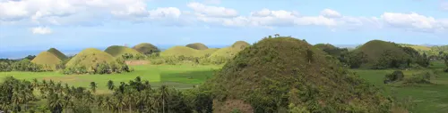
- Sagbayan San Agustin top view, Route 853, chocolate hills (Sagbayan, Bohol; 01-13-2023), Patrickroque01, CC BY-SA 4.0
- Second Image of the inside of the Saint Augustine Parish Church, ItsMeGabeProductions, CC0
- ISS028-E-36734 - View of Earth, Earth Science and Remote Sensing Unit , Lyndon B. Johnson Space Center, Public domain
- Chocolate Hills, Bohol, Chazelbryce, CC BY-SA 4.0
- Bodiga, 影丸, CC0
- Sagbayan Peak - Panoramic view, Dagon Hoyohoy, CC BY 2.0
Page built November 7, 2026. Spotted a mistake? Tell us or suggest a place.