


Santa Rita, Philippines
Santa Rita is a town of 4,338 people in Eastern Visayas, Philippines.
Why visit Santa Rita
Townapedia lists 7 places to eat and 2 attractions in and around town.
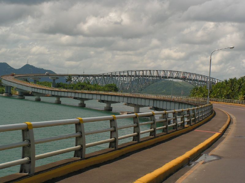
Highlights include San Juanico Bridge.
Weather in Santa Rita
Forecast from MET Norway (CC BY 4.0). Full forecast
About Santa Rita
Santa Rita, officially the Municipality of Santa Rita (Waray: Bungto han Santa Rita; Tagalog: Bayan ng Santa Rita), is a municipality in the province of Samar, Philippines. According to the 2024 census, it has a population of 42,397 people.
From the Wikipedia article Santa Rita, Samar (this version), under CC BY-SA 4.0.
Things to do2
San Juanico Bridge
Bridge · 16.7 km
Long truss bridge in the Philippines

Restaurants and cafes7



Churches and places of worship6


Gas and EV charging3



History
Local tradition dates the founding of this town in late 18th century. According to some aged inhabitants, the original settlers were the tribes of the Amistoso, Lacambra, and Agoy. Joaquin Amistoso rose to be their leader. The San Juanico Strait was supposed to have been named in his honor. These people made their living by fishing and small-scale farming. Captain Bartolome Sanchez, the head of a Spanish expedition in 1800, was captivated by the friendliness and hospitality of the people in the island so he decided to stay and help them. He called the neighboring tribes to unite with them and appointed Joaquin Amistoso to be the Cabeza de Barangay.
In years between 1810 and 1898, several attempts of fleet of Moro vintas or “pancos” who tried to rob the puro's golden bell, which was given by the Spaniards. Aged inhabitants believed that this bell had a melodious sound, which echoed up to Mindanao. This attracted the Moros who kept on attempting to raid the place. The tribes who guarded the bell to keep it safe in the “puro” fought against the moros. The ruins of the fortress locally known as “barawalte” still stands today and are mute evidence of Moro raids in the past. Today, the question of the whereabouts of the bell is still on the minds of the people because it is nowhere to be found.
From the History section of Santa Rita, Samar on Wikipedia, under CC BY-SA 4.0.
Schools, colleges and libraries138
University of the Philippines Tacloban College Sta. Elena Campus
School · 12.4 km
Healthcare3
Map of Santa Rita
159 places. The map loads OpenStreetMap tiles when you open it.
Getting there and nearby towns
Daniel Z. Romualdez Airport (TAC) is the nearest airport with scheduled flights listed in OpenStreetMap, 26 km away.
- Tacloban 24 km south, about 24 min by car
- Palo 33 km south, about 33 min by car
- Carigara 33 km southwest, about 33 min by car
- Catbalogan 37 km north, about 37 min by car
- Tanauan 39 km south, about 39 min by car
- Burauen 53 km south, about 53 min by car
- Borongan 56 km east, about 56 min by car
- Dulag 56 km south, about 56 min by car
- Ormoc 61 km southwest, about 1 h by car
- Calbayog City 78 km northwest, about 1 h 15 min by car
Drive times are estimates from straight-line distance, not routes.
Local news
Headlines from INDB.
Reviews, tips and questions
Loading what members have shared...
Sources and licences
- GeoNames (CC BY 4.0): population, coordinates, regions and time zone
- Mapillary (see each image): photos
- OpenStreetMap contributors (ODbL 1.0): places, airports, map data
- Wikidata (CC0 1.0): elevation, founding date, time zone, website, landmarks and historic places
- Wikimedia Commons (see each image): photos
- Wikipedia (CC BY-SA 4.0): overview and history text
Photo credits
- Municipal Hall, Erik, CC BY-SA 4.0
- San Juanico Bridge, byron alcantara from Fredon, United States, Public domain
- UPVTC, JinJian ( talk ), CC BY-SA 3.0
- Street-level photo, maning, CC BY-SA 4.0
- Street-level photo, Julius_Caezar_Macadine, CC BY-SA 4.0
- Street-level photo, Julius_Caezar_Macadine, CC BY-SA 4.0
Page built November 7, 2026. Spotted a mistake? Tell us or suggest a place.