
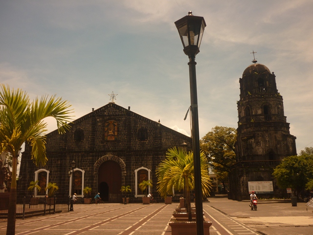


Tabaco, Philippines
Tabaco is a town of 57,860 people in Bicol Region, Philippines, founded in 1731.
Why visit Tabaco
Townapedia lists 9 museums and landmarks, 7 parks and trails, 61 places to eat, 13 places to stay and 2 attractions in and around town.
Highlights include Mayon Planetarium and Science Park and Tabaco Presidencia Building.
Weather in Tabaco
Forecast from MET Norway (CC BY 4.0). Full forecast
About Tabaco
Tabaco, officially the City of Tabaco (Central Bikol: Syudad kan Tabaco; Filipino: Lungsod ng Tabaco), is a component city in the province of Albay, Philippines. According to the 2024 census, it has a population of 140,779 people.
From the Wikipedia article Tabaco (this version), under CC BY-SA 4.0.
Travel tips from other travellers: Tabaco on Wikivoyage (CC BY-SA 4.0).
Things to do2

Museums and landmarks9

Mayon Planetarium and Science Park
Museum · 10.7 km
Planetarium and Geology museum



Parks, trails and playgrounds7



Restaurants and cafes61




49 more on the map.
Where to stay13
Churches and places of worship42
Iglesia ni Cristo
Church · Iglesia Ni Cristo · 1.2 km
Legazpi-Santo Domingo-Tabaco Road, Tabaco City
Our Lady of Lourdes Filipino-Chinese Personal Parish
Church · Roman Catholic · 0.6 km
Arellano Street, Tabaco City
Shopping24
Gas and EV charging22
Schools, colleges and libraries98
Bicol University, Tabaco Campus
School · 0.6 km
M.H. Del Pilar Street, Tabaco City
Healthcare41
Dr. Lorenzo P. Ziga Memorial District Hospital
Hospital · 1.3 km
Karangahan Boulevard
HealthQuarters Medical and Diagnostic
Clinic and pharmacy · 0.7 km
A. A. Berces Street
Rural Health Unit Malilipot
Clinic and pharmacy · 4.3 km
Bordonada Street, Malilipot, Albay
Map of Tabaco
250 places. The map loads OpenStreetMap tiles when you open it.
Getting there and nearby towns
Legazpi Airport (LGP) is the nearest airport with scheduled flights listed in OpenStreetMap, 22 km away.
- Miliroc 4 km southwest, about 4 min by car
- Sugcad 4 km west, about 4 min by car
- Malilipot 4 km south, about 4 min by car
- Tiwi 13 km northwest, about 13 min by car
- Legaspi 24 km south, about 24 min by car
- Iriga City 36 km west, about 36 min by car
- Tigaon 40 km northwest, about 40 min by car
- Sorsogon 51 km southeast, about 51 min by car
- Virac 60 km northeast, about 1 h by car
- Naga 66 km northwest, about 1 h by car
Drive times are estimates from straight-line distance, not routes.
Local news
Headlines from INDB.
Reviews, tips and questions
Loading what members have shared...
Sources and licences
- GeoNames (CC BY 4.0): population, coordinates, regions and time zone
- OpenStreetMap contributors (ODbL 1.0): places, airports, map data
- Wikidata (CC0 1.0): elevation, founding date, time zone, website, landmarks and historic places
- Wikimedia Commons (see each image): photos
- Wikipedia (CC BY-SA 4.0): overview and history text
Photo credits
- Tabaco Church, Kuya kyon, CC BY-SA 3.0
- Tabaco Presidencia Building NHCP historical marker, Photo: Carlo Joseph Moskito ; perspective correction: Eugene Alvin Villar ( seav ), CC BY-SA 4.0
- Tabaco City Public Market 2025, Aerous, CC BY 4.0
- Tabaco Presidencia Building marker (2), Carlo Joseph Moskito, CC BY-SA 4.0
- Tabaco Presidencia Building marker (1), Carlo Joseph Moskito, CC BY-SA 4.0
- Tabaco City Church, Aerous, CC BY 4.0
- Old House in Tabaco City, Aerous, CC BY 4.0
- Tabaco, Albay, Sheanjean, CC BY-SA 4.0
- Tabaco Cemetery Chapel (2517084409), Shubert Ciencia from Nueva Ecija, Philippines, CC BY 2.0
- Tabaco Presidencia Building historical marker - NHCP, National Historical Commission of the Philippines, Public domain
- Old House in Tobaco City, Aerous, CC BY 4.0
- Tobaco City Hall, Aerous, CC BY 4.0
- Rizal Monument in Tobaco City, Aerous, CC BY 4.0
- Mayon Volcano Sunset, Nor Llorca, CC BY-SA 4.0
- Malilipot, Albay Banner for Wikivoyage, Zcarstvnz Author of original photo: Patrickroque01, CC BY 4.0
- ISS044-E-58370 - View of Earth, Earth Science and Remote Sensing Unit , Lyndon B. Johnson Space Center, Public domain
- Malilipot Church 2005 - Flickr, Shubert Ciencia from Nueva Ecija, Philippines, CC BY 2.0
- Barbecue in Malilipot (S. Ciencia pic) - Flickr, Shubert Ciencia from Nueva Ecija, Philippines, CC BY 2.0
- Malilipot church inside (S. Ciencia pic) - Flickr, Shubert Ciencia from Nueva Ecija, Philippines, CC BY 2.0
- ISS044-E-58369 - View of Earth, Earth Science and Remote Sensing Unit , Lyndon B. Johnson Space Center, Public domain
- Locust 2, Aileen, CC BY-SA 4.0
- Damselfly 4, Aileen, CC BY-SA 4.0
- Mayo flower, Aileen, CC BY-SA 4.0
- The beautiful Mt. Mayon, Aileen, CC BY-SA 4.0
- ISS044-E-58371 - View of Earth, Earth Science and Remote Sensing Unit , Lyndon B. Johnson Space Center, Public domain


Page built November 7, 2026. Spotted a mistake? Tell us or suggest a place.