
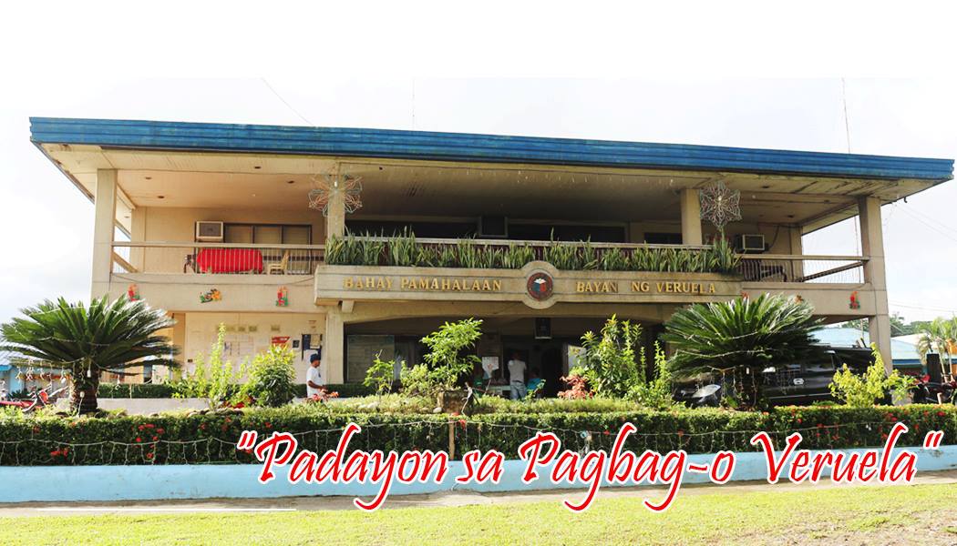


Why visit Veruela
Townapedia lists 2 museums and landmarks, 4 parks and trails, 7 places to eat, 2 places to stay and 4 attractions in and around town.
Weather in Veruela
Forecast from MET Norway (CC BY 4.0). Full forecast
About Veruela
Veruela, officially the Municipality of Veruela (Cebuano: Lungsod sa Veruela; Tagalog: Bayan ng Veruela), is a municipality in the province of Agusan del Sur, Philippines. According to the 2024 census, it has a population of 43,085 people.
From the Wikipedia article Veruela (this version), under CC BY-SA 4.0.
Things to do4


Museums and landmarks2


Parks, trails and playgrounds4

Restaurants and cafes7



History
Veruela is considered the oldest town of upper Agusan del Sur. It is believed the name "Veruela" derives from the word "virus", as the area suffered from smallpox and cholera in the late 18th century when Spanish missionaries encountered the indigenous Manobo tribes.
The Manobo later moved to Manning, also known as Linongsuran, along the Agusan River. In 1916, an earthquake destroyed the settlement, forcing the survivors to evacuate and reorganize themselves into another place, now the barangay poblacion of the municipality.
In the 18th century, Muslim tribes in Davao invaded the Manobos in Agusan, and the two sides fought. The first known leader of the Manobo was the datu Eladio Manguyod, who drove the Muslims out after a hard-fought battle. During this period, the tribe converted to Christianity and adopted Saint John as their patron.
Veruela became a municipality through Executive Order No. 147, which was proclaimed by President Diosdado Macapagal on March 31, 1965 during the term of Congressman Guillermo Sanchez, who once also served as mayor of the town. Since its formal creation as a municipality, Veruela has seen eight different administrations.
The municipality of Veruela has a silent dispute with the nearby province of Compostela Valley regarding the boundary between the two in Barangay Del Monte.
From the History section of Veruela on Wikipedia, under CC BY-SA 4.0.
Where to stay2
Churches and places of worship19
Kingdom Hall of Jehovah's Witnesses
Church · Jehovahs Witness · 7.2 km
Purok-4, Tapaz, Sta. Josefa
Kingdom Hall of Jehovah's Witnesses
Church · Jehovahs Witness · 13.2 km
Davao-Agusan National Highway
Lokal ng Veruela, Iglesia ni Cristo
Church · Iglesia Ni Cristo
Bunawan-Veruela Road
Shopping1
Gas and EV charging14
Caltex
Gas station · 12.3 km
Butuan City-Talacogon-Loreto-Veruela-Santa Josefa Road, Santa Josefa
RPM
Gas station · 12.8 km
Butuan City-Talacogon-Loreto-Veruela-Santa Josefa Road, Santa Josefa
Schools, colleges and libraries88
Agusan del Sur State College of Agriculture and Technology
School · 12.0 km
Agusan Del Sur State University - Trento Annex
School · 12.4 km
Davao-Agusan National Highway, Trento
Kapatungan Elementary School
School · 8.7 km
Davao-Agusan National Highway, Trento
Santa Josefa Central Elementary School
School · 12.0 km
Pioneer Street, Santa Josefa
Santa Josefa National High School
School · 12.1 km
6 Pioneer Street, Santa Josefa
Healthcare6
Brgy. Health Station
Hospital · 7.0 km
Purok -1, Tapaz, Sta. Josefa Agusan del Sur
Map of Veruela
147 places. The map loads OpenStreetMap tiles when you open it.
Getting there and nearby towns
Bislig Airport (BPH) is the nearest airport with scheduled flights listed in OpenStreetMap, 42 km away.
- Montevista 42 km south, about 42 min by car
- Bislig 43 km east, about 43 min by car
- Compostela 47 km south, about 47 min by car
- San Francisco 51 km north, about 51 min by car
- Nabunturan 52 km south, about 52 min by car
- Prosperidad 57 km north, about 57 min by car
- New Corella 56 km south, about 56 min by car
- Cambanugoy 63 km south, about 1 h by car
- Bayugan 79 km north, about 1 h 15 min by car
- Maco 80 km south, about 1 h 15 min by car
Drive times are estimates from straight-line distance, not routes.
Local news
Headlines from INDB.
Reviews, tips and questions
Loading what members have shared...
Sources and licences
- GeoNames (CC BY 4.0): population, coordinates, regions and time zone
- OpenStreetMap contributors (ODbL 1.0): places, airports, map data
- Wikidata (CC0 1.0): elevation, founding date, time zone, website, landmarks and historic places
- Wikimedia Commons (see each image): photos
- Wikipedia (CC BY-SA 4.0): overview and history text
Photo credits
- Veruela Municipal Hall, Municipality of Veruela, Agusan del Sur, Public domain
- ISS045-E-177019 - View of Earth, Earth Science and Remote Sensing Unit , Lyndon B. Johnson Space Center, Public domain
- ISS045-E-177020 - View of Earth, Earth Science and Remote Sensing Unit , Lyndon B. Johnson Space Center, Public domain
- ISS045-E-177018 - View of Earth, Earth Science and Remote Sensing Unit , Lyndon B. Johnson Space Center, Public domain
- ISS043-E-184005 - View of Earth, Earth Science and Remote Sensing Unit , Lyndon B. Johnson Space Center, Public domain
- ISS043-E-184003 - View of Earth, Earth Science and Remote Sensing Unit , Lyndon B. Johnson Space Center, Public domain
- ISS043-E-184004 - View of Earth, Earth Science and Remote Sensing Unit , Lyndon B. Johnson Space Center, Public domain
- ISS043-E-184006 - View of Earth, Earth Science and Remote Sensing Unit , Lyndon B. Johnson Space Center, Public domain


Page built November 7, 2026. Spotted a mistake? Tell us or suggest a place.