
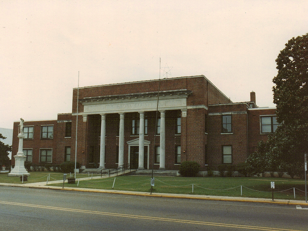


Philadelphia, Mississippi
Philadelphia is a city of 6,996 people in Neshoba County, Mississippi.
Why visit Philadelphia
Townapedia lists 3 museums and landmarks, 4 parks and trails, 3 places to eat and 1 attraction in and around town.
Highlights include Canal Place Cinema 7, Downtown Philadelphia Historic District and Old United States Post Office (Philadelphia, Mississippi).
July is the warmest month, with average highs of 91°F; January lows average 35°F.
Weather in Philadelphia
Forecast from the National Weather Service. Full forecast
About Philadelphia
Philadelphia is a city in and the county seat of Neshoba County, Mississippi, United States. The population was 7,118 at the 2020 census.
From the Wikipedia article Philadelphia, Mississippi (this version), under CC BY-SA 4.0.
Things to do1

Museums and landmarks3

Downtown Philadelphia Historic District
Monument and historic site · National Register of Historic Places · 0.7 mi
Historic district in Philadelphia, Mississippi
Old United States Post Office (Philadelphia, Mississippi)
Monument and historic site · National Register of Historic Places · 0.8 mi
Former post office in Philadelphia, Mississippi, United States
Parks, trails and playgrounds4


Restaurants and cafes3


History
Philadelphia is incorporated as a municipality; it was given its current name, after Philadelphia, Pennsylvania, in 1903, two years before the railroad brought new opportunities and prosperity to the town. The history of the town and its influences—social, political and economic—can be seen in the many points of interest within and beyond the city limits. These range from the large ceremonial Indian mound and cave at Nanih Waiya, built approximately 1,700 years ago and sacred to the Choctaw; to the still thriving Williams Brothers Store, a true old-fashioned general store founded in 1907 and featured in National Geographic in 1937 as a source of anything from "horse collars to straw hats."
From the History section of Philadelphia, Mississippi on Wikipedia, under CC BY-SA 4.0.
Churches and places of worship17
Holy Cross Catholic Church
Church · Roman Catholic · 0.7 mi
406 Wilson Street, Philadelphia
Shopping1
Gas and EV charging3
Schools, colleges and libraries9
Neshoba Central Middle School
School · 2.0 mi
1000 St. Francis Drive, Philadelphia
Healthcare1
Map of Philadelphia
42 places. The map loads OpenStreetMap tiles when you open it.
Climate by month
Monthly table
| Month | High | Low | Rain |
|---|---|---|---|
| Jan | 56°F | 35°F | 5.8 in |
| Feb | 60°F | 38°F | 6.2 in |
| Mar | 68°F | 45°F | 6.1 in |
| Apr | 76°F | 52°F | 5.6 in |
| May | 82°F | 61°F | 4.5 in |
| Jun | 89°F | 68°F | 4.8 in |
| Jul | 91°F | 71°F | 5.4 in |
| Aug | 91°F | 70°F | 4.5 in |
| Sep | 87°F | 64°F | 3.5 in |
| Oct | 78°F | 52°F | 4.0 in |
| Nov | 67°F | 43°F | 4.6 in |
| Dec | 58°F | 37°F | 5.4 in |
U.S. Climate Normals 1991-2020 for Philadelphia 1 Wsw (1 mi away), rain and snow from Philadelphia 1.4 Se, NOAA NCEI.
People and cost of living
American Community Survey 5-year estimates, 2020-2024, U.S. Census Bureau. Estimates have margins of error, larger for small towns.
Disaster history
Neshoba County has had 19 federal disaster declarations since 2000, most often for severe storms.
- 2026-02-06: Severe Winter Storm (Winter Storm)
- 2026-01-24: Severe Winter Storm (Winter Storm)
- 2024-06-10: Severe Storms, Straight-Line Winds, Tornadoes, And Flooding (Severe Storm)
- 2023-08-12: Severe Storms, Straight-Line Winds, And Tornadoes. (Severe Storm)
- 2021-10-22: Hurricane Ida (Hurricane)
- 2021-08-28: Hurricane Ida (Hurricane)
OpenFEMA disaster declarations summaries.
Getting there and nearby towns
Louisville Winston County Airport (LMS) is the nearest airport with scheduled flights listed in OpenStreetMap, 26 miles away.
- Carthage 24 mi west, about 39 min by car
- Louisville 24 mi north, about 39 min by car
- Newton 31 mi south, about 50 min by car
- Kosciusko 33 mi northwest, about 54 min by car
- Nellieburg 33 mi southeast, about 53 min by car
- Forest 35 mi southwest, about 57 min by car
- Marion 36 mi southeast, about 58 min by car
- Meridian 37 mi southeast, about 59 min by car
- Macon 41 mi northeast, about 1 h by car
- Morton 43 mi southwest, about 1 h 15 min by car
Drive times are estimates from straight-line distance, not routes.
Local news
Headlines from INDB, the NEMICO news database.
Reviews, tips and questions
Loading what members have shared...
Sources and licences
- NCES EDGE (Public domain): public schools
- NOAA NCEI U.S. Climate Normals 1991-2020 (Public domain): climate by month
- OpenFEMA (Public domain): disaster declarations
- OpenStreetMap contributors (ODbL 1.0): places, airports, map data
- U.S. Census Bureau (Public domain): population, income, housing, education, commute
- Wikidata (CC0 1.0): elevation, founding date, time zone, website, landmarks and historic places
- Wikimedia Commons (see each image): photos
- Wikipedia (CC BY-SA 4.0): overview and history text
Photo credits
- Neshoba County Mississippi Courthouse, James Case, CC BY 2.0
- Philadelphia-Neshoba County Library plaque, Ktkvtsh, CC BY 4.0
- Beacon Street, Courthouse Square, Philadelphia, Mississippi, James Case from Philadelphia, Mississippi, U.S.A., CC BY 2.0
- Church Avenue, Philadelphia, Mississippi cropped - 13962455523, CapCase, CC BY 2.0
- Church Avenue, Philadelphia, Mississippi - 13939257342, CapCase, CC BY 2.0
- Philadelphia Police Department, CapCase, CC BY 2.0
- Philadelphia Police Department - 13938748061, CapCase, CC BY 2.0
- Old US Post Office (Philadelphia, Mississippi), Ditch Fisher, CC BY-SA 3.0
- Philadelphia, Mississippi, City Hall - 13939202512, CapCase, CC BY 2.0
- Philadelphia, Mississippi, City Hall - 13835671234, CapCase, CC BY 2.0
- Philadelphia, Mississippi, City Hall - 13962343753, CapCase, CC BY 2.0
- Deweese House (Philadelphia, Mississippi), Ditch Fisher, CC BY-SA 3.0
- Otis Rush Blues Trail Marker, Firecruise, CC BY-SA 4.0
- Old Benwalt Hotel - 13938771061, CapCase, CC BY 2.0
- Byrd Avenue, Courthouse Square - 13939447141, CapCase, CC BY 2.0
- Byrd Avenue, Westside Courthouse Square - 13962620903, CapCase, CC BY 2.0
- Beacon Street, Courthouse Square - 13962534243, CapCase, CC BY 2.0
- Ellis Theater - 13939057672, CapCase, CC BY 2.0
- Ellis Theater - 13939080042, CapCase, CC BY 2.0
- Neshoba County Courthouse - 13938869001, CapCase, CC BY 2.0
- Neshoba County Courthouse - 13835789894, CapCase, CC BY 2.0
- Courthouse Clock - 13939105282, CapCase, CC BY 2.0
- Neshoba County Courthouse - 13961995603, CapCase, CC BY 2.0
- Courthouse Clock - 13962301323, CapCase, CC BY 2.0
- Neshoba County Courthouse - 13938789172, CapCase, CC BY 2.0
- Neshoba County Courthouse - 13938888222, CapCase, CC BY 2.0
- Southside Courthouse Square, CapCase, CC BY 2.0
- Center Avenue - 13939320061, CapCase, CC BY 2.0
- Magnolias and Sassafras - 13939017662, CapCase, CC BY 2.0
- Magnolia Blues - 13939050121, CapCase, CC BY 2.0
- Masonic Temple - 13962128683, CapCase, CC BY 2.0
- Masonic Temple - 13962107473, CapCase, CC BY 2.0
- Eastside Courthouse Square - 13962080993, CapCase, CC BY 2.0
- Old Mars Brothers Building - 13938993111, CapCase, CC BY 2.0
- Center Avenue, Courthouse Square cropped - 13962516853, CapCase, CC BY 2.0
- Center Avenue, Courthouse Square - 13962492323, CapCase, CC BY 2.0
- Stribling Pharmacy, CapCase, CC BY 2.0
- Stribling Pharmacy detail, CapCase, CC BY 2.0
- The Citizens Bank - 13938616722, CapCase, CC BY 2.0
- Lamps - 13939428691, CapCase, CC BY 2.0


Page built October 30, 2026. Spotted a mistake? Tell us or suggest a place.