


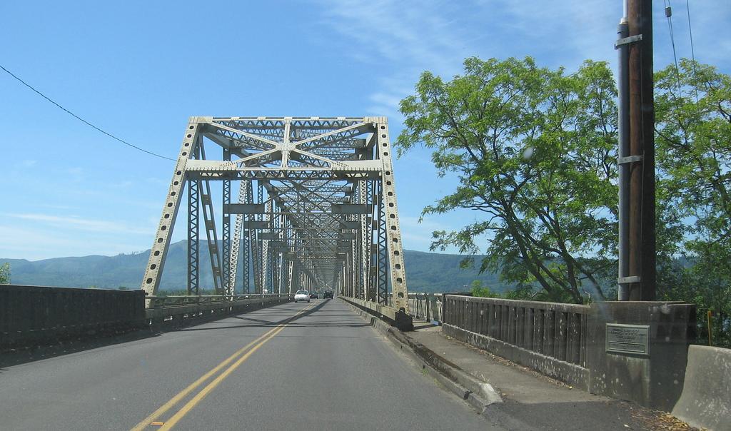


Puget Island, Washington
Puget Island is a community of 1,008 people in Wahkiakum County, Washington.
Why visit Puget Island
Townapedia lists 1 museum or landmark, 10 parks and trails, 9 places to eat, 15 places to stay and 3 attractions in and around town.
Highlights include Julia Butler Hansen Bridge and White Island Wildlife Area.
August is the warmest month, with average highs of 76°F; February lows average 33°F.
Weather in Puget Island
Forecast from the National Weather Service. Full forecast
About Puget Island
Puget Island is a 7.5 sq mi (4,785 acre; 19.365 km2) island and Census-designated place (CDP) in the Columbia River in Wahkiakum County, Washington, United States. The island was named for Peter Puget, a lieutenant in the Vancouver Expedition of exploration, which first mapped the island in 1792.
From the Wikipedia article Puget Island, Washington (this version), under CC BY-SA 4.0.
Things to do3

Julia Butler Hansen Bridge
Bridge · 1.4 mi
Bridge in United States of America

Museums and landmarks1

Parks, trails and playgrounds10





Restaurants and cafes9

Patty Cakes
Cafe · Coffee Shop, Sandwich · 1.8 mi
98 Main Street, Cathlamet
Mo-Sa 07:00-17:00


History
Puget Island was settled in 1884 by the Ostervold family. In addition to running dairy farms, farmers on the island grew mint from 1917 to the late 1940s. The next major crop grown on Puget Island was cucumbers, primarily for pickling, until the crops were damaged by mosaic disease. In the 1990s, sheep, dairying, and cottonwood were the main agricultural pursuits.
From the History section of Puget Island, Washington on Wikipedia, under CC BY-SA 4.0.
Where to stay15
Churches and places of worship8
Pioneer Church
Church · None · National Register of Historic Places · 1.8 mi
St. James Episcopal Church
Church · Episcopal · 1.4 mi
1134 Columbia Street, Cathlamet
The Church of Jesus Christ of Latter-day Saints
Church · Mormon · 2.4 mi
35 Messinger Hill Drive, Cathlamet
Shopping3
Gas and EV charging2
Schools, colleges and libraries6
Julius A Wendt Elementary/John C Thomas Middle School
School · 1.8 mi
265 South Third St, Cathlamet
Healthcare1
Map of Puget Island
58 places. The map loads OpenStreetMap tiles when you open it.
Climate by month
Monthly table
| Month | High | Low | Rain | Snow |
|---|---|---|---|---|
| Jan | 47°F | 33°F | 8.3 in | 0.5 in |
| Feb | 50°F | 33°F | 5.7 in | 0.7 in |
| Mar | 54°F | 35°F | 6.1 in | 0.2 in |
| Apr | 59°F | 38°F | 4.3 in | 0.0 in |
| May | 65°F | 44°F | 2.7 in | 0.0 in |
| Jun | 69°F | 48°F | 1.7 in | 0.0 in |
| Jul | 75°F | 52°F | 0.6 in | 0.0 in |
| Aug | 76°F | 52°F | 0.7 in | 0.0 in |
| Sep | 72°F | 48°F | 2.1 in | 0.0 in |
| Oct | 62°F | 41°F | 4.5 in | 0.0 in |
| Nov | 52°F | 36°F | 8.6 in | 0.1 in |
| Dec | 46°F | 33°F | 9.4 in | 0.8 in |
U.S. Climate Normals 1991-2020 for Clatskanie (10 mi away), NOAA NCEI.
People and cost of living
American Community Survey 5-year estimates, 2020-2024, U.S. Census Bureau. Estimates have margins of error, larger for small towns.
Disaster history
Wahkiakum County has had 22 federal disaster declarations since 2000, most often for severe storms.
- 2026-04-07: Severe Storms, Straight-Line Winds, Flooding, Landslides, And Mudslides (Flood)
- 2025-12-12: Severe Storms, Straight-Line Winds, Flooding, Landslides, And Mudslides (Flood)
- 2024-04-28: Severe Winter Storms, Straight-Line Winds, Flooding, Landslides, And Mudslides (Severe Storm)
- 2023-01-12: Severe Winter Storm, Straight-Line Winds, Flooding, Landslides, And Mudslides (Severe Storm)
- 2022-03-29: Severe Winter Storms, Snowstorms, Straight-Line Winds, Flooding (Flood)
- 2021-04-08: Severe Winter Storm, Straight-Line Winds, Flooding, Landslides, And Mudslides (Severe Storm)
OpenFEMA disaster declarations summaries.
Getting there and nearby towns
Southwest Washington Regional Airport (KLS) is the nearest airport with scheduled flights listed in OpenStreetMap, 24 miles away.
- Clatskanie 10 mi southeast, about 16 min by car
- Longview 20 mi east, about 32 min by car
- Longview Heights 20 mi east, about 33 min by car
- Astoria 21 mi west, about 33 min by car
- Lexington 22 mi east, about 36 min by car
- Beacon Hill 22 mi east, about 36 min by car
- Rainier 23 mi east, about 37 min by car
- Kelso 24 mi east, about 39 min by car
- Vernonia 24 mi southeast, about 38 min by car
- Castle Rock 24 mi east, about 38 min by car
Drive times are estimates from straight-line distance, not routes.
Local news
Headlines from INDB, the NEMICO news database.
Reviews, tips and questions
Loading what members have shared...
Sources and licences
- NCES EDGE (Public domain): public schools
- NOAA NCEI U.S. Climate Normals 1991-2020 (Public domain): climate by month
- OpenFEMA (Public domain): disaster declarations
- OpenStreetMap contributors (ODbL 1.0): places, airports, map data
- U.S. Census Bureau (Public domain): population, income, housing, education, commute
- Wikidata (CC0 1.0): elevation, founding date, time zone, website, landmarks and historic places
- Wikimedia Commons (see each image): photos
- Wikipedia (CC BY-SA 4.0): overview and history text
Photo credits
- Julia Butler Hansen Bridge 3986, Walter Siegmund (talk), CC BY-SA 3.0
- Bridge from Cathlamet to Puget Island where ferry starts (6111092965), Robert Ashworth from Bellingham, WA., USA, CC BY 2.0
- Puget Island Bridge, atul666 from Portland, USA, CC BY-SA 2.0
- Puget Island, atul666 from Portland, USA, CC BY-SA 2.0
- 79 River Islands—Columbia River Estuary 16-9 ratio, 7200x4050 pixels, Washington State Department of Natural Resources, CC BY-SA 2.0
- Leaving Washington State on the Cathlamet Ferry (6111636708), Robert Ashworth from Bellingham, WA., USA, CC BY 2.0
- Wauna factory 2849, Chris Light, CC BY-SA 4.0
- Wauna factory 2847, Chris Light, CC BY-SA 4.0
- Wauna factory 2850, Chris Light, CC BY-SA 4.0
- Westport Slough 2846, Chris Light, CC BY-SA 4.0
- Cathlamet Pioneer Church - Cathlamet Washington, Ian Poellet, CC BY-SA 3.0
- Cathlamet Washington Downhill Longboard Competition 2, Thayne Tuason, CC BY-SA 4.0
- Preimpact photo of longboarder about to hit child on racecourse, Thayne Tuason, CC BY-SA 4.0
- Cathlamet Washington Setting Up Longboarding Racecourse, Thayne Tuason, CC BY-SA 4.0
- Cathlamet Washington Downhill Longboard Competition 1, Thayne Tuason, CC BY-SA 4.0
- Cathlamet Washington Trikes on Racecourse at Cathlamet Downhill Corral, Thayne Tuason, CC BY-SA 4.0
- Cathlamet Downhill Corral Longboard Contest- local kids trying to win prize, Thayne Tuason, CC BY-SA 4.0
- Wahkiakum 2, atul666 from Portland, USA, CC BY-SA 2.0
- Wahkiakum County Ferry, brx0 from Portland, USA, CC BY-SA 2.0
- ISS062-E-140804 - View of Earth, Earth Science and Remote Sensing Unit, NASA Johnson Space Center, Public domain
- ISS019-E-22090 - View of Oregon, Earth Science and Remote Sensing Unit , Lyndon B. Johnson Space Center, Public domain
- Julia Butler Hansen House NRHP 100010342 Wahkiakum County, WA, Jon Roanhaus, CC BY-SA 4.0
- Julia Butler Hansen House2 NRHP 100010342 Wahkiakum County, WA, Jon Roanhaus, CC BY-SA 4.0
- Wahkiakum County courthouse in Cathlamet (6111636172), Robert Ashworth from Bellingham, WA., USA, CC BY 2.0
- Hypochaeris radicata 2, Thayne Tuason, CC BY-SA 4.0
- Hypochaeris radicata 1, Thayne Tuason, CC BY-SA 4.0
- Impatiens capensis at Cathlamet Washington, Thayne Tuason, CC BY-SA 4.0
- Cathlamet Downhill Corral Boardercross Competition 1, Thayne Tuason, CC BY-SA 4.0
- Cathlamet Washington Boardercross Competition 2, Thayne Tuason, CC BY-SA 4.0
- Astoria to Mt Rainier (6089835009), KimonBerlin, CC BY-SA 2.0
- Cathlamet-Westport ferry 2013, Dicklyon, CC BY-SA 4.0
- Overhead view of U.S. 30 landslide (52536168776), Oregon Department of Transportation, CC BY 2.0


Page built October 30, 2026. Spotted a mistake? Tell us or suggest a place.