


Why visit Quinebaug
Townapedia lists 12 museums and landmarks, 5 parks and trails, 1 place to eat and 2 attractions in and around town.
Highlights include Buck Hill, Chancery Hill, Black Tavern and Capt. Seth Chandler House.
July is the warmest month, with average highs of 82°F; January lows average 15°F, and about 38 inches of snow fall in a normal year.
Weather in Quinebaug
Forecast from the National Weather Service. Full forecast
About Quinebaug
Quinebaug is a village and census-designated place (CDP) in Thompson, a town in Windham County, Connecticut, United States. As of the 2020 census, Quinebaug had a population of 1,114.
From the Wikipedia article Quinebaug, Connecticut (this version), under CC BY-SA 4.0.
Things to do2

Museums and landmarks12

Black Tavern
Monument and historic site · National Register of Historic Places · 2.3 mi
Building in Massachusetts, United States of America

Capt. Seth Chandler House
Monument and historic site · National Register of Historic Places · 1.8 mi
Historic house in Connecticut, United States

District Five Schoolhouse
Monument and historic site · National Register of Historic Places · 3.4 mi
Building in Massachusetts, United States

Dudley Hill Historic District
Monument and historic site · National Register of Historic Places · 2.4 mi
Historic district in Dudley, Massachusetts
Main Street Historic District
Monument and historic site · National Register of Historic Places · 3.7 mi
Historic district in Webster, Massachusetts, United States

Shumway Block
Monument and historic site · National Register of Historic Places · 3.6 mi
Building in Massachusetts, United States of America

Stevens Linen Works Historic District
Monument and historic site · National Register of Historic Places · 3.5 mi
Historic textile mill district in Dudley, Worcester County, Massachusetts, USA
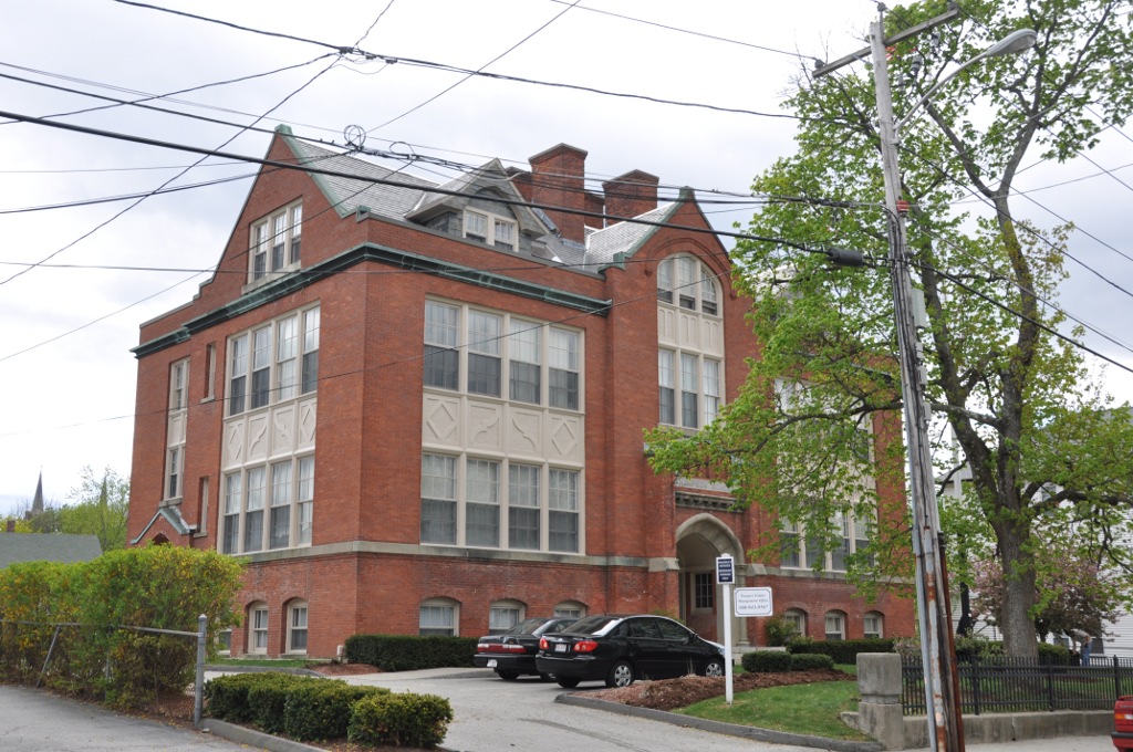
Thompson School
Monument and historic site · National Register of Historic Places · 3.9 mi
Listed on the NRHP in Worcester County, Massachusetts

Webster Municipal Buildings Historic District
Monument and historic site · National Register of Historic Places · 3.8 mi
Historic district in Massachusetts, United States

Eddy Block
Monument and historic site · National Register of Historic Places · 3.6 mi

Spaulding Block
Monument and historic site · National Register of Historic Places · 3.6 mi


Civil War Memorial
Monument and historic site · 3.8 mi
Monument in Webster, Massachusetts
Parks, trails and playgrounds5


Restaurants and cafes1

Churches and places of worship4
Quinebaug Seventh-day Adventist Church
Church · Seventh Day Adventist · 1.3 mi
768 Quinebaug Road, Thompson
Shopping1
Schools, colleges and libraries15
Mary R. Fisher Elementary School
School · 3.1 mi
785 Riverside Dr., North Grosvenordale
Tourtellotte Memorial High School
School · 3.1 mi
785 Riverside Dr., North Grosvenordale
Map of Quinebaug
40 places. The map loads OpenStreetMap tiles when you open it.
Climate by month
Monthly table
| Month | High | Low | Rain | Snow |
|---|---|---|---|---|
| Jan | 35°F | 15°F | 3.8 in | 10.6 in |
| Feb | 38°F | 16°F | 3.5 in | 11.6 in |
| Mar | 46°F | 24°F | 4.5 in | 7.2 in |
| Apr | 58°F | 34°F | 4.6 in | 1.5 in |
| May | 69°F | 45°F | 3.4 in | 0.0 in |
| Jun | 76°F | 54°F | 4.5 in | 0.0 in |
| Jul | 82°F | 60°F | 4.0 in | 0.0 in |
| Aug | 80°F | 58°F | 4.2 in | 0.0 in |
| Sep | 73°F | 51°F | 3.9 in | 0.0 in |
| Oct | 61°F | 38°F | 4.8 in | 0.2 in |
| Nov | 50°F | 30°F | 4.2 in | 0.9 in |
| Dec | 40°F | 22°F | 4.7 in | 6.5 in |
U.S. Climate Normals 1991-2020 for W Thompson Lake (5 mi away), NOAA NCEI.
People and cost of living
American Community Survey 5-year estimates, 2020-2024, U.S. Census Bureau. Estimates have margins of error, larger for small towns.
Disaster history
The county has had 22 federal disaster declarations since 2000, most often for hurricanes.
- 2021-08-22: Hurricane Henri (Hurricane)
- 2021-01-12: Tropical Storm Isaias (Hurricane)
- 2020-08-06: Tropical Storm Isaias (Hurricane)
- 2020-03-28: Covid-19 Pandemic (Biological)
- 2020-03-13: Covid-19 (Biological)
- 2015-04-08: Severe Winter Storm And Snowstorm (Severe Storm)
OpenFEMA disaster declarations summaries.
Getting there and nearby towns
Worcester Regional Airport (ORH) is the nearest airport with scheduled flights listed in OpenStreetMap, 18 miles away.
- North Grosvenor Dale 2 mi southeast, about 4 min by car
- Webster 4 mi northeast, about 6 min by car
- Southbridge Town 6 mi northwest, about 10 min by car
- South Woodstock 6 mi south, about 9 min by car
- Putnam 7 mi south, about 11 min by car
- Oxford 8 mi northeast, about 13 min by car
- Sturbridge 9 mi northwest, about 14 min by car
- Holland 11 mi west, about 18 min by car
- East Douglas 12 mi northeast, about 19 min by car
- Fiskdale 12 mi northwest, about 19 min by car
Drive times are estimates from straight-line distance, not routes.
Local news
Headlines from INDB, the NEMICO news database.
Reviews, tips and questions
Loading what members have shared...
Sources and licences
- NCES EDGE (Public domain): public schools
- NOAA NCEI U.S. Climate Normals 1991-2020 (Public domain): climate by month
- OpenFEMA (Public domain): disaster declarations
- OpenStreetMap contributors (ODbL 1.0): places, airports, map data
- U.S. Census Bureau (Public domain): population, income, housing, education, commute
- Wikidata (CC0 1.0): elevation, founding date, time zone, website, landmarks and historic places
- Wikimedia Commons (see each image): photos
- Wikipedia (CC BY-SA 4.0): overview and history text
Photo credits
- St Stephens Church, Quinebaug CT, John Phelan, CC BY-SA 3.0
- Southbridge Branch bridge off Quinebaug Road, September 2024, Pi.1415926535, CC BY-SA 4.0
- Quinebaug Market, Quinebaug CT, John Phelan, CC BY 4.0
- Quinebaug station postcard, Unknown author Unknown author, Public domain
- Quinebaug River Trail, Shsusbsvusbsvzjsb, CC BY 4.0
- Downtown Webster Mass, Marcbela (Marc N. Belanger), Public domain
- DudleyMA BlackTavern, User:Magicpiano, CC BY-SA 4.0
- WebsterMA DudleyWebsterHistoricalSociety, User:Magicpiano, CC BY-SA 4.0
- DudleyMA StevensLinenFactory, User:Magicpiano, CC BY-SA 4.0
- WebsterMA ThompsonSchool, User:Magicpiano, CC BY-SA 4.0
- Nichols College, Dudley Massachusetts (May 2007), Criticalpub, CC BY-SA 3.0
- WoodstockCT CaptSethChandlerHouse, User:Magicpiano, CC BY-SA 4.0
- WebsterMA TownHall, User:Magicpiano, CC BY-SA 4.0
- WebsterMA ShumwayBlock, User:Magicpiano, CC BY-SA 4.0
- WebsterMA SpauldingBlock, User:Magicpiano, CC BY-SA 4.0
- Eddy Block Webster, Marcbela (Marc N. Belanger), Public domain
- Webster MA Civil War memorial, Kenneth C. Zirkel, CC BY-SA 4.0
- Fabyan Cemetery, Fabyan CT, John Phelan, CC BY 4.0
- Honor Roll World War II, Fabyan CT, John Phelan, CC BY 4.0
- Fabyan Road, Fabyan CT, John Phelan, CC BY 4.0
- Fabyan Dam, Fabyan CT, John Phelan, CC BY-SA 4.0
- ISS014-E-17712 - View of Massachusetts, Earth Science and Remote Sensing Unit , Lyndon B. Johnson Space Center, Public domain
- ISS047-E-7867 - View of Earth, Earth Science and Remote Sensing Unit , Lyndon B. Johnson Space Center, Public domain
- ISS048-E-19488 - View of Earth, Earth Science and Remote Sensing Unit , Lyndon B. Johnson Space Center, Public domain
- ISS047-E-7869 - View of Earth, Earth Science and Remote Sensing Unit , Lyndon B. Johnson Space Center, Public domain
- ISS030-E-122505 - View of Earth, Earth Science and Remote Sensing Unit , Lyndon B. Johnson Space Center, Public domain
- ISS054-E-47011 - View of Earth, Earth Science and Remote Sensing Unit, NASA Johnson Space Center, Public domain
- ISS047-E-7868 - View of Earth, Earth Science and Remote Sensing Unit , Lyndon B. Johnson Space Center, Public domain


Page built October 30, 2026. Spotted a mistake? Tell us or suggest a place.