
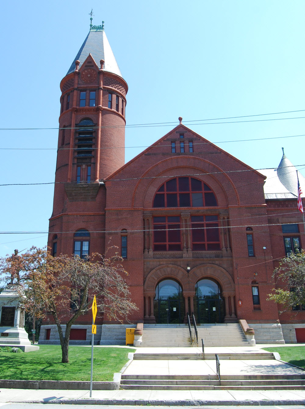


Southbridge Town, Massachusetts
Southbridge Town is a city of 17,928 people in Worcester County, Massachusetts, founded in 1730.
Why visit Southbridge Town
Townapedia lists 85 museums and landmarks, 23 parks and trails, 18 places to eat, 8 places to stay and 9 attractions in and around town.
Highlights include Draper Hills, Griggs Hill, Bacon–Morse Historic District and Central Mills Historic District.
July is the warmest month, with average highs of 81°F; January lows average 17°F, and about 52 inches of snow fall in a normal year.
Weather in Southbridge Town
Forecast from the National Weather Service. Full forecast
About Southbridge Town
Southbridge is a city in Worcester County, Massachusetts, United States. The population was 17,740 at the 2020 census. Although Southbridge has a city form of government, it is legally known as the Town of Southbridge.
From the Wikipedia article Southbridge, Massachusetts (this version), under CC BY-SA 4.0.
Things to do9

Museums and landmarks85

Bacon–Morse Historic District
Monument and historic site · National Register of Historic Places · 1.9 mi
Historic district in Southbridge, Massachusetts, United States

Central Mills Historic District
Monument and historic site · National Register of Historic Places · 1.2 mi
Historic district in Massachusetts, United States

Globe Village Fire House
Monument and historic site · National Register of Historic Places · 1.5 mi
Fire station in Southbridge, United States of America
11 West Street
Glover Street Historic District
Monument and historic site · National Register of Historic Places · 1.2 mi
Historic district in Massachusetts, United States

Holy Trinity Episcopal Church
Monument and historic site · Episcopal · National Register of Historic Places · 1.6 mi
Church building in Massachusetts, United States
446 Hamilton Street

Southbridge station
Monument and historic site · National Register of Historic Places · 1.2 mi
Former railway station in Southbridge, Massachusetts, US
6 Larochelle Way

Upper Chapin Street Historic District
Monument and historic site · National Register of Historic Places · 0.9 mi
Historic district in Massachusetts, United States
Windsor Court Historic District
Monument and historic site · National Register of Historic Places · 1.1 mi
Southbridge, MA, listed on the NRHP in Massachusetts

A. Kinney House
Monument and historic site · National Register of Historic Places · 1.3 mi
House in Southbridge, Massachusetts


Academie Brochu
Monument and historic site · National Register of Historic Places · 1.4 mi
School building in Southbridge, Massachusetts
Albert H. Wheeler House
Monument and historic site · National Register of Historic Places · 1.3 mi
House in Southbridge, Massachusetts
Alden-Delahanty Block
Monument and historic site · National Register of Historic Places · 1.6 mi
Commercial building in Southbridge, Massachusetts
73 more on the map.
Parks, trails and playgrounds23

Claire Birtz Wildlife Sanctuary
Hiking and trails · 2.1 mi
May-Aug Su-Sa,PH (sunrise-00:30)-20:00; Sep-Apr Su-Sa,PH...


Pond Factory Road Open Space
Hiking and trails · 2.5 mi
Municipal, Open To Public Without Fee; Existing Preserved Open Space; Town Open Space (Pond Factory Road)
11 more on the map.
Restaurants and cafes18

Annie's Country Kitchen
Diner · American · 2.9 mi
140 Main Street, Sturbridge
Mo-Tu 05:00-14:00; We-Fr 05:00-19:00; Sa 05:00-12:00; Su 06:00-12:00



Dunkin'
Fast food · Donut, Coffee Shop · 1.2 mi
419 Main Street, Southbridge
Mo-Sa 04:00-20:00; Su 05:00-20:00
6 more on the map.
History
The area was initially inhabited by the Nipmuck and Mohegan tribes, with the Quinebaug River dividing their territories. As early as 1638, John Winthrop Jr. purchased Tantiusques, a tract for mining "lead" centered at what is now Leadmine Road in Sturbridge (it was thought at the time that where there was lead, there should be silver nearby). In fact the mineral deposit was graphite which the Winthrops commercialized employing Nipmuck miners.
Southbridge was first settled by Europeans in 1730. In 1801 a poll parish, named the Second Religious Society of Charlton, and popularly called Honest Town, was formed from the west part of Dudley, the southwest part of Charlton and the southeast part of Sturbridge. In 1816 this parish was incorporated to become the township of Southbridge. Among the first settlers was Moses Marcy, who owned a home on the site of what is now Notre Dame church and was elected to Congress, and the Dennison family. Water power from the Quinebaug River made Southbridge a good location for sawmills and gristmills in the 18th century, and textile mills in the 19th century. After the Civil War, many immigrants of Irish and French Canadian descent came to work and live there; by the 1930s they had been joined by Poles, Greeks, Italians and others.
From the History section of Southbridge, Massachusetts on Wikipedia, under CC BY-SA 4.0.
Where to stay8
Churches and places of worship14
Notre Dame Catholic Church
Church · Roman Catholic · National Register of Historic Places · 1.3 mi
446 Main Street, Southbridge
Elm Street Congregational Church
Church · United Church Of Christ · 0.9 mi
61 Elm Street, Southbridge
Congregational Church
Church · National Register of Historic Places · 0.9 mi
St. George's Greek Orthodox Church
Church · National Register of Historic Places · 1.2 mi
Saint Nicholas Albanian Orthodox Church
Church · Albanian Orthodox · 0.8 mi
126 Morris Street, Southbridge
St. Michael's Romanian Orthodox Church of Southbridge
Church · Romanian Orthodox · 0.9 mi
16 Roumanian Avenue, Southbridge
Shopping6
Gas and EV charging8
Schools, colleges and libraries20
Old Sturbridge Academy Charter Public School
School · 4.8 mi
1 Old Sturbridge Village Road, Sturbridge
Healthcare2
Map of Southbridge Town
193 places. The map loads OpenStreetMap tiles when you open it.
Climate by month
Monthly table
| Month | High | Low | Rain | Snow |
|---|---|---|---|---|
| Jan | 35°F | 17°F | 4.0 in | 14.7 in |
| Feb | 36°F | 18°F | 3.5 in | 14.7 in |
| Mar | 45°F | 25°F | 4.6 in | 9.2 in |
| Apr | 58°F | 35°F | 4.4 in | 1.8 in |
| May | 68°F | 46°F | 3.7 in | 0.0 in |
| Jun | 77°F | 55°F | 4.4 in | 0.0 in |
| Jul | 81°F | 60°F | 4.3 in | 0.0 in |
| Aug | 79°F | 59°F | 4.4 in | 0.0 in |
| Sep | 72°F | 51°F | 4.2 in | 0.0 in |
| Oct | 59°F | 39°F | 5.0 in | 0.2 in |
| Nov | 49°F | 31°F | 4.1 in | 1.5 in |
| Dec | 39°F | 23°F | 5.1 in | 10.3 in |
U.S. Climate Normals 1991-2020 for Southbridge 3 Sw (2 mi away), NOAA NCEI.
People and cost of living
American Community Survey 5-year estimates, 2020-2024, U.S. Census Bureau. Estimates have margins of error, larger for small towns.
Disaster history
Worcester County has had 24 federal disaster declarations since 2000, most often for severe storms.
- 2024-05-15: Severe Storms And Flooding (Flood)
- 2023-09-15: Hurricane Lee (Hurricane)
- 2020-03-27: Covid-19 Pandemic (Biological)
- 2020-03-13: Covid-19 (Biological)
- 2018-07-19: Severe Winter Storm And Snowstorm (Snowstorm)
- 2015-04-13: Severe Winter Storm, Snowstorm, And Flooding (Severe Storm)
OpenFEMA disaster declarations summaries.
Getting there and nearby towns
Worcester Regional Airport (ORH) is the nearest airport with scheduled flights listed in OpenStreetMap, 17 miles away.
- Palmer Town 17 mi northwest, about 27 min by car
- Worcester 19 mi northeast, about 30 min by car
- Storrs 21 mi southwest, about 33 min by car
- Willimantic 25 mi south, about 41 min by car
- Springfield 26 mi west, about 42 min by car
- Milford 27 mi east, about 44 min by car
- Longmeadow 27 mi west, about 44 min by car
- Chicopee 29 mi west, about 46 min by car
- Manchester 32 mi southwest, about 51 min by car
- Marlborough 32 mi northeast, about 51 min by car
Drive times are estimates from straight-line distance, not routes.
Local news
Headlines from INDB, the NEMICO news database.
Reviews, tips and questions
Loading what members have shared...
Sources and licences
- NCES EDGE (Public domain): public schools
- NOAA NCEI U.S. Climate Normals 1991-2020 (Public domain): climate by month
- OpenFEMA (Public domain): disaster declarations
- OpenStreetMap contributors (ODbL 1.0): places, airports, map data
- U.S. Census Bureau (Public domain): population, income, housing, education, commute
- Wikidata (CC0 1.0): elevation, founding date, time zone, website, landmarks and historic places
- Wikimedia Commons (see each image): photos
- Wikipedia (CC BY-SA 4.0): overview and history text
Photo credits
- Southbridge Town Hall, Marcbela (Marc N. Belanger), Public domain
- Notre Dame Southbridge, Marcbela (Marc N. Belanger), Public domain
- Evangelical Free Church, Southbridge, MA - DSC02659, Daderot, CC0
- Central Mills Southbridge, Marcbela (Marc N. Belanger), Public domain
- SouthbridgeMA 100 GloverStreet, User:Magicpiano, CC BY-SA 4.0
- SouthbridgeMA WindsorCourt, User:Magicpiano, CC BY-SA 4.0
- Globe Village Fire House, Southbridge MA, John Phelan, CC BY-SA 3.0
- SouthbridgeMA BaconMorseHD 1, User:Magicpiano, CC BY-SA 4.0
- Southbridge station from the southwest, June 2021, Pi.1415926535, CC BY-SA 4.0
- Napoleon LaRochelle Two-Family House, Southbridge, MA - DSC02666, Daderot, CC0
- 18 Walnut Street, Southbridge MA, John Phelan, CC BY-SA 3.0
- SouthbridgeMA DunbarVintonHouse, User:Magicpiano, CC BY-SA 4.0
- William E. Alden House, Southbridge MA, John Phelan, CC BY-SA 3.0
- Samuel C. Hartwell House, Southbridge MA, John Phelan, CC BY 3.0
- H. Morse House, Southbridge MA, John Phelan, CC BY 3.0
- SouthbridgeMA ChamberlainBordeauHouse, User:Magicpiano, CC BY-SA 4.0
- Tantiusques - IMG 7327, Daderot, Public domain
- SouthbridgeMA LorenzoRStoneHouse, User:Magicpiano, CC BY-SA 4.0
- Alexis Boyer House, Southbridge MA, John Phelan, CC BY-SA 3.0
- J.M. Cheney Rental House, Southbridge MA, John Phelan, CC BY 3.0
- Hamilton Woolen Mill Southbridge, Marcbela (Marc N. Belanger), Public domain
- SouthbridgeMA GeorgeHHartwellHouse, User:Magicpiano, CC BY-SA 4.0
- 16 High Street, Southbridge MA, John Phelan, CC BY-SA 3.0
- DudleyMA BlackTavern, User:Magicpiano, CC BY-SA 4.0
- Beechwood, Southbridge MA, John Phelan, CC BY 3.0
- 52 Marcy Street, Southbridge MA, John Phelan, CC BY-SA 3.0
- Academie Brochu, Southbridge MA, John Phelan, CC BY 3.0
- 64 South Street, Southbridge MA, John Phelan, CC BY-SA 3.0
- SouthbridgeMA 52MainSt, User:Magicpiano, CC BY-SA 4.0
- SouthbridgeMA AKinneyHouse, User:Magicpiano, CC BY-SA 4.0
- Eugene Tapin House, Southbridge, MA - DSC02635, Daderot, CC0
- Federated Church of Sturbridge and Fiskdale, Sturbridge MA, John Phelan, CC BY-SA 3.0
- St. George Greek Orthodox Church, Southbridge MA, John Phelan, CC BY-SA 3.0
- LaCroix-Mosher House, Southbridge MA, John Phelan, CC BY 3.0
- Vinton-Boardman Farmhouse, Halliepup, Public domain
- SouthbridgeMA 34 BenefitStreet, User:Magicpiano, CC BY-SA 4.0
- J.J. Oakes House, Southbridge MA, John Phelan, CC BY 3.0
- Tiffany-Leonard House, Southbridge MA, John Phelan, CC BY-SA 3.0
- 45 West Street, Southbridge MA, John Phelan, CC BY-SA 3.0
- 38-42 Worcester Street, Southbridge MA, John Phelan, CC BY-SA 3.0


Page built October 30, 2026. Spotted a mistake? Tell us or suggest a place.