


Why visit Rumson
Townapedia lists 18 museums and landmarks, 18 parks and trails, 25 places to eat, 2 places to stay and 7 attractions in and around town.
Highlights include Count Basie Theatre, Chapel Hill Rear Range Light, Allen House and Anthony Reckless Estate.
July is the warmest month, with average highs of 84°F; January lows average 25°F.
Weather in Rumson
Forecast from the National Weather Service. Full forecast
About Rumson
Rumson is a borough in Monmouth County, in the U.S. state of New Jersey, and is part of the New York Metropolitan Area. As of the 2020 United States census, the borough's population was 7,343, an increase of 221 (+3.1%) from the 2010 census count of 7,122, which in turn reflected a decline of 15 (−0.2%) from 7,137 in 2000.
From the Wikipedia article Rumson, New Jersey (this version), under CC BY-SA 4.0.
Things to do7
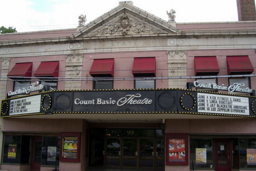
Count Basie Theatre
Cinema and theater · National Register of Historic Places · 3.6 mi
Theater in Red Bank, New Jersey, United States

Chapel Hill Rear Range Light
Lighthouse · 3.8 mi
Lighthouse in New Jersey, United States

Highlands–Sea Bright Bridge
Bridge · 2.7 mi
Bridge in United States of America

Marion Huber Theater
Cinema and theater · 3.8 mi
Smaller stage of the Two River Theater in Red Bank, New Jersey
Rumson–Sea Bright Bridge
Bridge · 1.5 mi
Lifting road bridge in New Jersey, US
Two River Theater
Cinema and theater · 3.8 mi
Theater in Red Bank, New Jersey
Museums and landmarks18

Allen House
Monument and historic site · National Register of Historic Places · 4.0 mi
Historic house in Shrewsbury, New Jersey

Anthony Reckless Estate
Monument and historic site · National Register of Historic Places · 3.4 mi
Historic house in Monmouth County, New Jersey
Highlands Air Force Station
Monument and historic site · National Register of Historic Places · 2.1 mi
Former military installation in Middletown Township, New Jersey

Little Silver
Monument and historic site · National Register of Historic Places · 3.1 mi
NJ Transit rail station
Navesink Twin Lights
Monument and historic site · National Register of Historic Places · 2.6 mi
Lighthouse in New Jersey, United States
North Long Branch School-Primary No. 3
Monument and historic site · National Register of Historic Places · 3.2 mi
School building in New Jersey, United States of America

Parker Homestead
Monument and historic site · National Register of Historic Places · 3.1 mi
Building in New Jersey, United States
Red Bank
Monument and historic site · National Register of Historic Places · 3.8 mi
New Jersey Transit rail station in Red Bank, New Jersey, United States
T. Thomas Fortune House
Monument and historic site · National Register of Historic Places · 3.9 mi
Historic house in New Jersey, United States
Wardell House
Monument and historic site · National Register of Historic Places · 4.1 mi
Historic house in New Jersey, United States

Water Witch Club Casino
Monument and historic site · National Register of Historic Places · 2.7 mi
Building in New Jersey, United States


Water Witch Club Historic District
Monument and historic site · National Register of Historic Places · 2.7 mi
Historic district in New Jersey, United States
6 more on the map.
Parks, trails and playgrounds18




Shrewsbury River Yacht Club
Marina and boat launch · 1.4 mi
925 River Road, Fair Haven
6 more on the map.
Restaurants and cafes25

Tommy's Tavern + Tap
Restaurant · Pizza, Wings, Salad, Sandwich, Soup, Sushi · 1.6 mi
1030 Ocean Avenue, Sea Bright
Su-Th 11:00-23:00; Fr-Sa 11:00-24:00
Alice's Kitchen
Restaurant · Breakfast · 1.6 mi
1108 Ocean Avenue, Sea Bright
Mo-Fr 06:30-15:00; Sa 06:00-14:30; Su 06:00-13:30

Barnacle Bill's
Diner · American · 1.1 mi
1 1st Street, Rumson
Tu,Th 16:00-22:00; Fr,Sa 12:00-23:00; Su 12:00-21:00
Yolk's on you Kitchen
Restaurant · Breakfast · 1.6 mi
1132 East Ocean Avenue, Sea Bright
07:00-16:00; Fr,Sa 07:00-20:00

Almost Home Coffee
Cafe · Coffee Shop · 1.6 mi
1136 Ocean Avenue, Sea Bright
06:30-14:30
13 more on the map.
History
Legend has it that the borough's name is derived from early European settlers who bought the land from the local Lenape Native Americans in exchange for some rum. But as far back as 1663, long before the area was officially named Rumson, Native Americans called it "Navarumsunk". Over the years it has been shortened to "Rumson", though sources also talk of a Chief Alumson as a source of the name. Other names Rumson has been known by include Black Point, Port Washington and Oceanic.
Rumson was purchased by English settlers in pieces. The first purchase was dated January 25, 1665, and it included parts of Middletown. The rest of the area was purchased later that year.
Rumson is known for its many sprawling 19th-century estates located alongside the shores of the Navesink and Shrewsbury rivers and also dotted along the historic Rumson Road (serving as one of Rumson's main thoroughfares). Now an upscale commuter suburb, Rumson was once a prominent summer colony for wealthy New York bankers and industrialists during the turn of the century, c. 1900. The oldest of Rumson's homes was the Tredwell House, named after a family that summered there for almost 100 years. The oldest part of the house was from 1670, and the estate once occupied 700 acres (2.8 km2). It was the second-oldest building in Monmouth County when it was destroyed by fire in June 2006.
From the History section of Rumson, New Jersey on Wikipedia, under CC BY-SA 4.0.
Where to stay2
Churches and places of worship12
First Presbyterian Church of Rumson
Church · Presbyterian · National Register of Historic Places · 1.0 mi
All Saint's Memorial Church
Church · National Register of Historic Places · 2.7 mi
Christ Church (Episcopal), Shrewsbury
Church · National Register of Historic Places · 4.0 mi
St. George's-by-the-River Episcopal Church
Church · National Register of Historic Places · 1.4 mi
St. John's Episcopal Church
Church · National Register of Historic Places · 2.5 mi
Shopping4
Gas and EV charging1
Schools, colleges and libraries49
Atlantic Highlands Elementary School
School · 3.8 mi
140 First Avenue, Atlantic Highlands
Map of Rumson
136 places. The map loads OpenStreetMap tiles when you open it.
Climate by month
Monthly table
| Month | High | Low | Rain |
|---|---|---|---|
| Jan | 42°F | 25°F | 4.2 in |
| Feb | 43°F | 26°F | 3.3 in |
| Mar | 49°F | 32°F | 4.3 in |
| Apr | 59°F | 41°F | 3.9 in |
| May | 68°F | 51°F | 4.1 in |
| Jun | 78°F | 61°F | 4.3 in |
| Jul | 84°F | 67°F | 4.4 in |
| Aug | 82°F | 65°F | 6.3 in |
| Sep | 76°F | 59°F | 4.3 in |
| Oct | 66°F | 47°F | 4.7 in |
| Nov | 56°F | 37°F | 3.8 in |
| Dec | 47°F | 30°F | 4.8 in |
U.S. Climate Normals 1991-2020 for Long Branch-Oakhurst Hcn (5 mi away), NOAA NCEI.
People and cost of living
American Community Survey 5-year estimates, 2020-2024, U.S. Census Bureau. Estimates have margins of error, larger for small towns.
Disaster history
Monmouth County has had 16 federal disaster declarations since 2000, most often for hurricanes.
- 2021-09-05: Remnants Of Hurricane Ida (Hurricane)
- 2021-09-02: Remnants Of Hurricane Ida (Hurricane)
- 2020-12-11: Tropical Storm Isaias (Hurricane)
- 2020-03-25: Covid-19 Pandemic (Biological)
- 2020-03-13: Covid-19 (Biological)
- 2016-03-14: Severe Winter Storm And Snowstorm (Severe Storm)
OpenFEMA disaster declarations summaries.
Getting there and nearby towns
Monmouth Executive Airport (BLM) is the nearest airport with scheduled flights listed in OpenStreetMap, 14 miles away.
- Fair Haven 2 mi west, about 3 min by car
- Monmouth Beach 2 mi southeast, about 3 min by car
- Little Silver 2 mi southwest, about 4 min by car
- Highlands 3 mi north, about 5 min by car
- Red Bank 3 mi west, about 5 min by car
- Oceanport 3 mi south, about 5 min by car
- Navesink 3 mi northwest, about 5 min by car
- Atlantic Highlands 4 mi north, about 6 min by car
- Fairview 4 mi west, about 6 min by car
- Long Branch 5 mi south, about 8 min by car
Drive times are estimates from straight-line distance, not routes.
Local news
Headlines from INDB, the NEMICO news database.
Reviews, tips and questions
Loading what members have shared...
Sources and licences
- NCES EDGE (Public domain): public schools
- NOAA NCEI U.S. Climate Normals 1991-2020 (Public domain): climate by month
- OpenFEMA (Public domain): disaster declarations
- OpenStreetMap contributors (ODbL 1.0): places, airports, map data
- U.S. Census Bureau (Public domain): population, income, housing, education, commute
- Wikidata (CC0 1.0): elevation, founding date, time zone, website, landmarks and historic places
- Wikimedia Commons (see each image): photos
- Wikipedia (CC BY-SA 4.0): overview and history text
Photo credits
- LAURISTON, RUMSON, MONMOUTH COUNTY, NJ, KLOTZ, CC BY-SA 4.0
- 2018-05-28 19 12 30 View east along Monmouth County Route 520 (Rumson Road) at Buena Vista Avenue in Rumson, Monmouth County, New Jersey, Famartin, CC BY-SA 4.0
- Piping Rock Park, Rumson, NJ, Aug. 2025, Mr. Matté (if there is an issue with this image, contact me using this image's Commons talk page , my Commons user talk page , or my English Wikipedia user talk page ; I'll know about it a lot faster), CC BY-SA 4.0
- 2018-05-28 19 23 15 View west along Monmouth County Route 520 (Rumson Road) at Monmouth County Route 34 (Avenue of Two Rivers) in Rumson, Monmouth County, New Jersey, Famartin, CC BY-SA 4.0
- Oceanic Free Library, Rumson, NJ, Aug. 2025, Mr. Matté (if there is an issue with this image, contact me using this image's Commons talk page , my Commons user talk page , or my English Wikipedia user talk page ; I'll know about it a lot faster), CC BY-SA 4.0
- Rumson Black Point, Wikijazz, CC BY-SA 3.0
- Monmouth CR 10 eb, Rumson, NJ, Aug. 2025, Mr. Matté (if there is an issue with this image, contact me using this image's Commons talk page , my Commons user talk page , or my English Wikipedia user talk page ; I'll know about it a lot faster), CC BY-SA 4.0
- Rumson New Home, Wikijazz, CC BY-SA 3.0
- Rumson, NJ Borough Hall, Aug. 2025, Mr. Matté (if there is an issue with this image, contact me using this image's Commons talk page , my Commons user talk page , or my English Wikipedia user talk page ; I'll know about it a lot faster), CC BY-SA 4.0
- Rumson New Hall, Wikijazz, CC BY-SA 3.0
- Rumson boroughhall, Wikijazz, CC BY-SA 3.0
- Rumson WW I, Wikijazz, CC BY-SA 3.0
- First Presbyterian Church of Rumson (5), Apc106, CC BY-SA 3.0
- First Presbyterian Church of Rumson, NJ, Aug. 2025, Mr. Matté (if there is an issue with this image, contact me using this image's Commons talk page , my Commons user talk page , or my English Wikipedia user talk page ; I'll know about it a lot faster), CC BY-SA 4.0
- Victory park, Rumson, NJ - panoramio, febb, CC BY-SA 3.0
- Rumson Shield, Wikijazz, CC BY-SA 3.0
- Rumson, NJ Country Club, Aug. 2025, Mr. Matté (if there is an issue with this image, contact me using this image's Commons talk page , my Commons user talk page , or my English Wikipedia user talk page ; I'll know about it a lot faster), CC BY-SA 4.0
- New Rumson-Sea Bright Bridge eb (1), Aug. 2025, Mr. Matté (if there is an issue with this image, contact me using this image's Commons talk page , my Commons user talk page , or my English Wikipedia user talk page ; I'll know about it a lot faster), CC BY-SA 4.0
- New Rumson-Sea Bright Bridge eb (2), Aug. 2025, Mr. Matté (if there is an issue with this image, contact me using this image's Commons talk page , my Commons user talk page , or my English Wikipedia user talk page ; I'll know about it a lot faster), CC BY-SA 4.0
- New Rumson-Sea Bright Bridge wb (3), Aug. 2025, Mr. Matté (if there is an issue with this image, contact me using this image's Commons talk page , my Commons user talk page , or my English Wikipedia user talk page ; I'll know about it a lot faster), CC BY-SA 4.0
- New Rumson-Sea Bright Bridge eb (3), Aug. 2025, Mr. Matté (if there is an issue with this image, contact me using this image's Commons talk page , my Commons user talk page , or my English Wikipedia user talk page ; I'll know about it a lot faster), CC BY-SA 4.0
- Shrusberry River Bridge, Rumson, NJ - panoramio, febb, CC BY-SA 3.0
- New Rumson-Sea Bright Bridge wb (2), Aug. 2025, Mr. Matté (if there is an issue with this image, contact me using this image's Commons talk page , my Commons user talk page , or my English Wikipedia user talk page ; I'll know about it a lot faster), CC BY-SA 4.0
- 2018-05-28 19 16 50 View east along Monmouth County Route 520 (Rumson Road) just west of New Jersey State Route 36 (Ocean Avenue) in Sea Bright, Monmouth County, New Jersey, Famartin, CC BY-SA 4.0
- 2025-04-23 10 01 35 The Sea Bright Shrewsbury Network weather station on Monmouth County Route 520 (Rumson-Sea Bright Bridge) in Sea Bright, Monmouth County, New Jersey, Famartin, CC BY-SA 4.0
- 2025-04-23 10 02 07 Tipping bucket rain gauge on the Sea Bright Shrewsbury Network weather station on Monmouth County Route 520 (Rumson-Sea Bright Bridge) in Sea Bright, Monmouth County, New Jersey, Famartin, CC BY-SA 4.0
- 2025-04-23 10 01 48 Anemometer and temperature-humidity sensors on the Sea Bright Shrewsbury Network weather station on Monmouth County Route 520 (Rumson-Sea Bright Bridge) in Sea Bright, Monmouth..., Famartin, CC BY-SA 4.0
- New Rumson-Sea Bright Bridge wb (1), Aug. 2025, Mr. Matté (if there is an issue with this image, contact me using this image's Commons talk page , my Commons user talk page , or my English Wikipedia user talk page ; I'll know about it a lot faster), CC BY-SA 4.0
- 2025-04-23 10 01 23 The Sea Bright USGS weather station (foreground) and the Sea Bright Shrewsbury Network weather station (background) on Monmouth County Route 520 (Rumson-Sea Bright Bridge) in Sea..., Famartin, CC BY-SA 4.0
- 2025-04-23 10 02 44 Novalynx tipping bucket rain gauge on the Sea Bright USGS weather station on Monmouth County Route 520 (Rumson-Sea Bright Bridge) in Sea Bright, Monmouth County, New Jersey, Famartin, CC BY-SA 4.0
- 2025-04-23 10 03 05 Lower portion of the Sea Bright USGS weather station on Monmouth County Route 520 (Rumson-Sea Bright Bridge) in Sea Bright, Monmouth County, New Jersey, Famartin, CC BY-SA 4.0
- Fisk Chapel (7), Apc106, CC BY-SA 3.0
- Beautiful facade of All Saints, Navesink, Bestbudbrian, CC BY-SA 4.0
- Basie theatre, Wikijazz at English Wikipedia, Public domain
- Water Witch Club Casino, east view, Zeete, CC BY-SA 3.0
- Episcopalian church in Shrewsbury New Jersey on Route 35, Tomwsulcer, CC0
- LSticketbooth, Wikijazz at English Wikipedia, Public domain
- Anthony Reckless Estate, Red Bank, New Jersey (3969287329), Jazz Guy from New Jersey, United States, CC BY 2.0
- Water Witch Club Historic District, West Twin Road - 1, Zeete, CC BY-SA 3.0
- Parker Homestead (1), Apc106, CC BY-SA 3.0


Page built October 30, 2026. Spotted a mistake? Tell us or suggest a place.